tóng-àn:Earth-apollo17.jpg

Seng khoàⁿ chiàm-liōng: 600 × 600 siōng-sò͘. Kî-thaⁿ--ê kái-sek-tō͘: 240 × 240 siōng-sò͘ | 480 × 480 siōng-sò͘ | 640 × 640 siōng-sò͘.
Choân kái-sek-tō͘ (640 × 640 siōng-sò͘ , tóng-àn chiàm-liōng: 91 KB, MIME luī-hêng: image/jpeg)
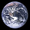
Tē-kiû: Chit tiuⁿ siòng sī Apollo 17 thài-khong-lâng Harrison Schmitt tī 1972-nî 12-go̍eh chhe-7 (khì go̍eh-niû ê lō·--nih) hip--ê. Hui-chiu, Lâm-ke̍k kap A-la-pek Pòan-tó khoàⁿ hiān-hiān. Chit-chōa sī lō·-bóe 1-pái ū lâng lī-khui kīn-tē-kiû kúi-tō (low Earth orbit), mā sī î-it 1-pái ū tē-lí ha̍k-ka khì go̍eh-kiû.
Ē-kha sī siòng ê goân-pán biâu-su̍t:
- View of the Earth as seen by the Apollo 17 crew traveling toward the moon. This translunar coast photograph extends from the Mediterranean Sea area to the Antarctica south polar ice cap. This is the first time the Apollo trajectory made it possible to photograph the south polar ice cap. Note the heavy cloud cover in the Southern Hemisphere. Almost the entire coastline of Africa is clearly visible. The Arabian Peninsula can be seen at the northeastern edge of Africa. The large island off the coast of Africa is the Malagasy Republic. The Asian mainland is on the horizon toward the northeast.
NASA ū chhiau-koân phín-chit ê pán-pún.
Pán-koân: Kong-kiōng châi-sán (Public Domain).
Tóng-àn le̍k-sú
Chhi̍h ji̍t-kî/sî-kan, khoàⁿ hit sî-chūn--ê tóng-àn.
| Ji̍t-kî/Sî-kan | Sáuk-liŏk-dù | Chióh-cháung | Iōng-chiá | Chù-kái | |
|---|---|---|---|---|---|
| hiān-chāi | 2004-nî 6-goe̍h 23-ji̍t (pài-saⁿ) 23:12 |  | 640 × 640(91 KB) | A-giâu(thó-lūn | kòng-hiàn) | Tē-kiû, Apollo 17 hip--ê. |
汝無年呆覆蓋茲萆文件。
Iáⁿ-siōng liân-kiat
Í-hā ê ia̍h liân kàu chit ê iáⁿ-siōng:
