
tóng-àn:Europe map Napoleon 1811.svg

此 SVG 檔案的 PNG 預覽的大小:415 × 422 siōng-sò͘。 Kî-thaⁿ--ê kái-sek-tō͘: 236 × 240 siōng-sò͘ | 472 × 480 siōng-sò͘ | 755 × 768 siōng-sò͘ | 1,007 × 1,024 siōng-sò͘ | 2,014 × 2,048 siōng-sò͘.
Choân kái-sek-tō͘ (SVG ùng-giông, chék-cháung: 415 × 422 chuông-só, ùng-giông duâi-nâung:89 KB)
|
|
Che sī tùi Wikimedia Commons ín--lâi ê chi̍t hūn tóng-àn. I tī hia ê kì-su̍t-ia̍h téng-bīn ê chu-sìn hián-sī ùi ē-té. |

.jpg)
Khài-iàu
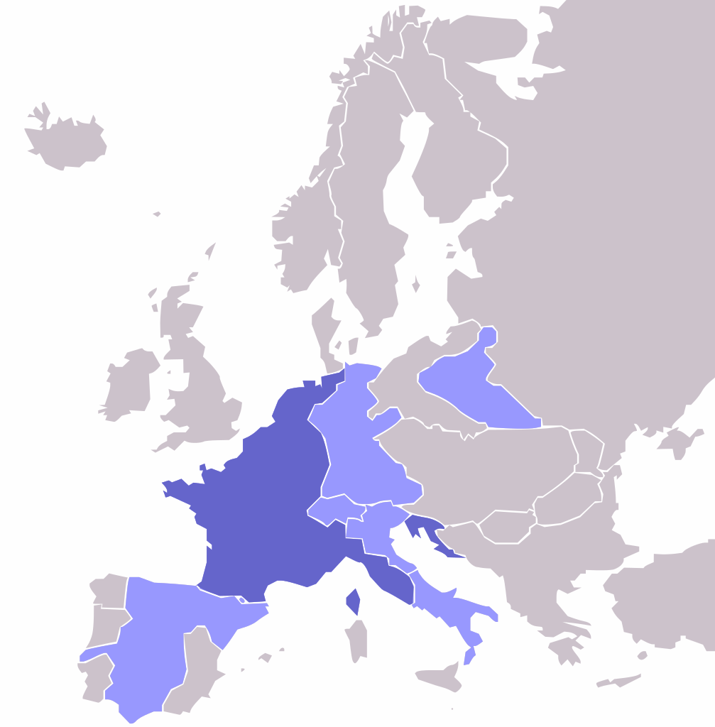
| Soat-bêng | Map of the w:First French Empire and satellite states, with w:1811 borders. Created by User:OwenBlacker from Image:Europe blank map.png, therefore they are the source. |
| Ji̍t-kî | (UTC) |
| Chhut-chhù | |
| Chok-chiá |
|
| 其他版本 | File:Europe map Napoleon 1811.png |
Siū-khoân
| 我,此作品的版權所有人,釋出此作品至公共領域。此授權條款在全世界均適用。 這可能在某些國家不合法,如果是的話: 我授予任何人有權利使用此作品於任何用途,除受法律約束外,不受任何限制。 |
原始上傳日誌
This image is a derivative work of the following images:
- File:Europe_map_Napoleon_1811.png licensed with PD-self
- 2006-10-16T00:53:12Z Deltabeignet 415x422 (13615 Bytes) Corrected status of Illyrian provinces.
- 2005-08-21T00:51:11Z OwenBlacker 415x422 (11762 Bytes) Map of the [[w:First French Empire]] and satellite states, with [[w:1811]] borders. Created by [[User:OwenBlacker]] from [[:Image:Europe blank map.png]] {{GFDL}} {{cc-by-sa-2.0-uk}}
Uploaded with derivativeFX
| 註解 | 該圖片含有註解:在維基媒體共享資源上查看註解 |
Tóng-àn le̍k-sú
Chhi̍h ji̍t-kî/sî-kan, khoàⁿ hit sî-chūn--ê tóng-àn.
| Ji̍t-kî/Sî-kan | Sáuk-liŏk-dù | Chióh-cháung | Iōng-chiá | Chù-kái | |
|---|---|---|---|---|---|
| hiān-chāi | 2009-nî 5-goe̍h 2-ji̍t (pài-la̍k) 23:14 | | 415 × 422(89 KB) | Mnmazur | {{Information |Description=Map of the w:First French Empire and satellite states, with w:1811 borders. Created by User:OwenBlacker from Image:Europe blank map.png, therefore they are the source. |Source=*[[:File:Europe_map_Napoleon_1811.p |
Iáⁿ-siōng liân-kiat
Í-hā ê ia̍h liân kàu chit ê iáⁿ-siōng:
tóng-àn hō͘ lâng sái--ê chōng-hóng
Ē-kha--ê kî-thaⁿ wiki ēng tio̍h chit--ê tóng-àn:
- ba.wikipedia.org hō͘ lâng ēng--ê chêng-hêng
- es.wikipedia.org hō͘ lâng ēng--ê chêng-hêng
- et.wikipedia.org hō͘ lâng ēng--ê chêng-hêng
- fr.wikipedia.org hō͘ lâng ēng--ê chêng-hêng
- hi.wikipedia.org hō͘ lâng ēng--ê chêng-hêng
- hu.wikipedia.org hō͘ lâng ēng--ê chêng-hêng
- hy.wikipedia.org hō͘ lâng ēng--ê chêng-hêng
- no.wikipedia.org hō͘ lâng ēng--ê chêng-hêng
- pl.wikipedia.org hō͘ lâng ēng--ê chêng-hêng
- ru.wikipedia.org hō͘ lâng ēng--ê chêng-hêng
- sr.wikipedia.org hō͘ lâng ēng--ê chêng-hêng
- sv.wikipedia.org hō͘ lâng ēng--ê chêng-hêng
- tl.wikipedia.org hō͘ lâng ēng--ê chêng-hêng
- tt.wikipedia.org hō͘ lâng ēng--ê chêng-hêng
- uk.wikipedia.org hō͘ lâng ēng--ê chêng-hêng
- yo.wikipedia.org hō͘ lâng ēng--ê chêng-hêng