
tóng-àn:Kansas City Kansas aerial view.jpg

Seng khoàⁿ chiàm-liōng: 800 × 534 siōng-sò͘. Kî-thaⁿ--ê kái-sek-tō͘: 320 × 214 siōng-sò͘ | 640 × 427 siōng-sò͘ | 1,024 × 683 siōng-sò͘ | 1,500 × 1,001 siōng-sò͘.
Choân kái-sek-tō͘ (1,500 × 1,001 siōng-sò͘ , tóng-àn chiàm-liōng: 579 KB, MIME luī-hêng: image/jpeg)
|
|
Che sī tùi Wikimedia Commons ín--lâi ê chi̍t hūn tóng-àn. I tī hia ê kì-su̍t-ia̍h téng-bīn ê chu-sìn hián-sī ùi ē-té. |
Khài-iàu
| Soat-bêng |
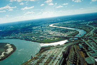
English: Aerial view of Kansas City, Kansas, looking southwest. The Kansas River (right-center) joins the Missouri River (left). A small piece of Kansas City, Missouri is visible on the left of the Missouri River. |
| 圖中地點 | City of Kansas City, State of Kansas, United States of America 39°6′54.64″N 94°36′36.34″W / 39.1151778°N 94.6100944°W |
| Ji̍t-kî | 攝於1999年4-goe̍h6日 |
| Chhut-chhù |
U.S. Army Corp of Engineers Digital Visual Library Image page Image description page Digital Visual Library home page |
| Chok-chiá | U.S. Army Corps of Engineers, photographer unknown |
Siū-khoân
This image or file is a work of a U.S. Army Corps of Engineers soldier or employee, taken or made as part of that person's official duties. As a work of the U.S. federal government, the image is in the public domain.
|
Tóng-àn le̍k-sú
Chhi̍h ji̍t-kî/sî-kan, khoàⁿ hit sî-chūn--ê tóng-àn.
| Ji̍t-kî/Sî-kan | Sáuk-liŏk-dù | Chióh-cháung | Iōng-chiá | Chù-kái | |
|---|---|---|---|---|---|
| hiān-chāi | 2007-nî 3-goe̍h 17-ji̍t (pài-la̍k) 01:48 | | 1,500 × 1,001(579 KB) | DanMS | {{Information | Description = Aerial view of Kansas City, Kansas, looking southwest. The Kansas River (right-center) joins the Missouri River (left). A small piece of Kansas City, Missouri is visible on the left of the Missouri River. | Source = U.S. |
Iáⁿ-siōng liân-kiat
Í-hā ê ia̍h liân kàu chit ê iáⁿ-siōng:
tóng-àn hō͘ lâng sái--ê chōng-hóng
Ē-kha--ê kî-thaⁿ wiki ēng tio̍h chit--ê tóng-àn:
- bo.wikipedia.org hō͘ lâng ēng--ê chêng-hêng
- br.wikipedia.org hō͘ lâng ēng--ê chêng-hêng
- cs.wikipedia.org hō͘ lâng ēng--ê chêng-hêng
- da.wikipedia.org hō͘ lâng ēng--ê chêng-hêng
- de.wikipedia.org hō͘ lâng ēng--ê chêng-hêng
- en.wikipedia.org hō͘ lâng ēng--ê chêng-hêng
- eo.wikipedia.org hō͘ lâng ēng--ê chêng-hêng
- es.wikipedia.org hō͘ lâng ēng--ê chêng-hêng
- fr.wikipedia.org hō͘ lâng ēng--ê chêng-hêng
- gd.wikipedia.org hō͘ lâng ēng--ê chêng-hêng
- gu.wikipedia.org hō͘ lâng ēng--ê chêng-hêng
- gv.wikipedia.org hō͘ lâng ēng--ê chêng-hêng
- hsb.wikipedia.org hō͘ lâng ēng--ê chêng-hêng
- hu.wikipedia.org hō͘ lâng ēng--ê chêng-hêng
- hy.wikipedia.org hō͘ lâng ēng--ê chêng-hêng
- id.wikipedia.org hō͘ lâng ēng--ê chêng-hêng
- ja.wikipedia.org hō͘ lâng ēng--ê chêng-hêng
- kn.wikipedia.org hō͘ lâng ēng--ê chêng-hêng
- ko.wikipedia.org hō͘ lâng ēng--ê chêng-hêng
- kw.wikipedia.org hō͘ lâng ēng--ê chêng-hêng
- ky.wikipedia.org hō͘ lâng ēng--ê chêng-hêng
- la.wikipedia.org hō͘ lâng ēng--ê chêng-hêng
- mr.wikipedia.org hō͘ lâng ēng--ê chêng-hêng
- mt.wikipedia.org hō͘ lâng ēng--ê chêng-hêng
- sc.wikipedia.org hō͘ lâng ēng--ê chêng-hêng
- simple.wikipedia.org hō͘ lâng ēng--ê chêng-hêng
- sk.wikipedia.org hō͘ lâng ēng--ê chêng-hêng
- sv.wikipedia.org hō͘ lâng ēng--ê chêng-hêng
- ug.wikipedia.org hō͘ lâng ēng--ê chêng-hêng
- uk.wikipedia.org hō͘ lâng ēng--ê chêng-hêng