
tóng-àn:Luzon Strait n7184.jpg

Seng khoàⁿ chiàm-liōng: 318 × 598 siōng-sò͘. Kî-thaⁿ--ê kái-sek-tō͘: 127 × 240 siōng-sò͘ | 542 × 1,020 siōng-sò͘.
Choân kái-sek-tō͘ (542 × 1,020 siōng-sò͘ , tóng-àn chiàm-liōng: 77 KB, MIME luī-hêng: image/jpeg)
|
|
Che sī tùi Wikimedia Commons ín--lâi ê chi̍t hūn tóng-àn. I tī hia ê kì-su̍t-ia̍h téng-bīn ê chu-sìn hián-sī ùi ē-té. |
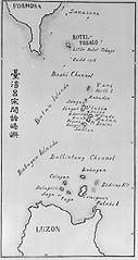
| Soat-bêng | Old map of the Luzon Strait (not labeled), including the Bashi Channel, between Orchid Island (Botel Tobago on the map) of Taiwan and the Batan Islands of the Philippines. Names may be out of date. Japanese caption: "Islands between Taiwan and Luzon". | |||||
| Ji̍t-kî | 日期不明 | |||||
| Chhut-chhù |
From digital archive of the University of Tokyo. [1] Cropped by a-giâu. |
|||||
| Chok-chiá | anthropologist Torii Ryūzō (1870-1953) | |||||
| 授權允准 (Bô siŏh-huòi sāi ciā ùng-giông) |
|


Tóng-àn le̍k-sú
Chhi̍h ji̍t-kî/sî-kan, khoàⁿ hit sî-chūn--ê tóng-àn.
| Ji̍t-kî/Sî-kan | Sáuk-liŏk-dù | Chióh-cháung | Iōng-chiá | Chù-kái | |
|---|---|---|---|---|---|
| hiān-chāi | 2004-nî 11-goe̍h 11-ji̍t (pài-sì) 23:30 | | 542 × 1,020(77 KB) | A-giâu | Old map of the Luzon Strait,(not labeled), including the Bashi Channel, between Orchid Island (Botel Tobago in the map) of Taiwan and the Batanes of the Philippines. Names may be out of date. From digital archive of the Universit |
Iáⁿ-siōng liân-kiat
Í-hā ê ia̍h liân kàu chit ê iáⁿ-siōng:
tóng-àn hō͘ lâng sái--ê chōng-hóng
Ē-kha--ê kî-thaⁿ wiki ēng tio̍h chit--ê tóng-àn:
- ar.wikipedia.org hō͘ lâng ēng--ê chêng-hêng
- ast.wikipedia.org hō͘ lâng ēng--ê chêng-hêng
- az.wikipedia.org hō͘ lâng ēng--ê chêng-hêng
- bcl.wikipedia.org hō͘ lâng ēng--ê chêng-hêng
- be.wikipedia.org hō͘ lâng ēng--ê chêng-hêng
- ca.wikipedia.org hō͘ lâng ēng--ê chêng-hêng
- ceb.wikipedia.org hō͘ lâng ēng--ê chêng-hêng
- cs.wikipedia.org hō͘ lâng ēng--ê chêng-hêng
- da.wikipedia.org hō͘ lâng ēng--ê chêng-hêng
- de.wikipedia.org hō͘ lâng ēng--ê chêng-hêng
- en.wikipedia.org hō͘ lâng ēng--ê chêng-hêng
- es.wikipedia.org hō͘ lâng ēng--ê chêng-hêng
- eu.wikipedia.org hō͘ lâng ēng--ê chêng-hêng
- fa.wikipedia.org hō͘ lâng ēng--ê chêng-hêng
- fr.wikipedia.org hō͘ lâng ēng--ê chêng-hêng
- he.wikipedia.org hō͘ lâng ēng--ê chêng-hêng
- hi.wikipedia.org hō͘ lâng ēng--ê chêng-hêng
- id.wikipedia.org hō͘ lâng ēng--ê chêng-hêng
- ilo.wikipedia.org hō͘ lâng ēng--ê chêng-hêng
- it.wikipedia.org hō͘ lâng ēng--ê chêng-hêng
- ja.wikipedia.org hō͘ lâng ēng--ê chêng-hêng
- ko.wikipedia.org hō͘ lâng ēng--ê chêng-hêng
- lt.wikipedia.org hō͘ lâng ēng--ê chêng-hêng
- mk.wikipedia.org hō͘ lâng ēng--ê chêng-hêng
- nl.wikipedia.org hō͘ lâng ēng--ê chêng-hêng
檢視此檔案的更多全域使用狀況。