tóng-àn:Qin empire 210 BCE TC.jpg

頁面內容不支援其他語言。
Che sī chi̍t hūn tùi Wikimedia Commons ín--lâi ê tóng-àn
Wikipedia (chū-iû ê pek-kho-choân-su) beh kā lí kóng...

Qin_empire_210_BCE_TC.jpg(555 × 545 siōng-sò͘ , tóng-àn chiàm-liōng: 274 KB, MIME luī-hêng: image/jpeg

Khài-iàu

Commentary

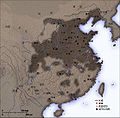
English: As part of his unification of China in 221 BC, Qin Shi Huang divided his empire into thirty six commanderies, each subdivided into a number of counties. The significance of the administrative reforms was its introduction of a uniformly centralised system of imperial control. The system was followed by the Han Dynasty, though with a certain degree of compromise. Thereafter, the system became the norm for later dynasties and eventually evolved into the present administrative structure of Mainland China. See: Political divisions of China.

The location of the Yellow River and commandery seats follows Tan Qixiang (ed.), Zhongguo lishi ditu (中国历史地图集), 1982. Note that the Yellow River is considerably to the north of its present flow.

The coloured territories show the approximate extent of Qin political control at the death of Qin Shi Huang in 210 BC. At that time more commanderies were added to the original thirty six, and these are also shown on the map.
閩南語 / Bân-lâm-gú:Tsîn-tiâu ê hîng-tsìng khu-ue̍h. 秦朝的行政區劃。

Created and copyright (2006) by Yeu Ninje. Released under the GNU FDL.

Originally uploaded to Chinese Wikipedia by zh:User:Yeu Ninje.

Siū-khoân

我,本作品的著作權持有者,決定用以下授權條款發佈本作品:
GNU head 已授權您依據自由軟體基金會發行的無固定段落、封面文字和封底文字GNU自由文件授權條款1.2版或任意後續版本,對本檔進行複製、傳播和/或修改。該協議的副本列在GNU自由文件授權條款中。
w:zh:創用CC
標示名姓 仝款方式方享
此檔案採用創用CC 姓名標示-相同方式分享 3.0 未在地化版本授權條款。
你會使自由:
  • 分享 – kho͘-pih, hoat-pò͘ kap thoân-pò͘ pún chok
  • 重新修改 – kái-pian pún chok-phín
Àn i-hā ê tiâu-kiāⁿ
  • 標示名姓 – 您必須指名出正確的製作者,和提供授權條款的連結,以及表示是否有對內容上做出變更。您可以用任何合理的方式來行動,但不得以任何方式表明授權條款是對您許可或是由您所使用。
  • 仝款方式方享 – Lí nā kái-tōng, piàn-khoán, he̍k-chiá kun-kù pún chok chhòng-chō, lí kaⁿ-taⁿ ē-tàng ēng kap pún chok kâng-khoán he̍k-chiá saⁿ-chhiūⁿ ê hí-khó lâi hoat-pò͘ chò--chhut-lâi ê chok-phín.
已新增授權條款標題至此檔案,作為GFDL授權更新的一部份。
Nṳ̄ buóh dĭk sié-nó̤h sêu-guòng dèu-kuāng dŭ kō̤-ī gēng.

Related images

說明

添加單行說明來描述出檔案所代表的內容
秦朝疆域图

在此檔案描寫的項目

描繪內容 繁體中文

著作權狀態 繁體中文

有著作權 繁體中文

多媒體型式 繁體中文

image/jpeg

Tóng-àn le̍k-sú

Chhi̍h ji̍t-kî/sî-kan, khoàⁿ hit sî-chūn--ê tóng-àn.

Ji̍t-kî/Sî-kanSáuk-liŏk-dùChióh-cháungIōng-chiáChù-kái
hiān-chāi2006-nî 11-goe̍h 21-ji̍t (pài-jī) 16:212006-nî 11-goe̍h 21-ji̍t (pài-jī) 16:21 bēng-buōng gì sáuk-liŏk-dù555 × 545(274 KB)Itsmine== Commentary == As part of his unification of China in 221 BC, Qin Shi Huang divided his empire into thirty six commanderies, each subdivided into a number of counties. The significance of the administrative reforms was its in

Í-hā ê ia̍h liân kàu chit ê iáⁿ-siōng:

tóng-àn hō͘ lâng sái--ê chōng-hóng

Ē-kha--ê kî-thaⁿ wiki ēng tio̍h chit--ê tóng-àn:

Nguòng-só-gé̤ṳ