
tóng-àn:Sepat 16 aug 2007 0225Z.jpg

Choân kái-sek-tō͘ (5,800 × 7,800 siōng-sò͘ , tóng-àn chiàm-liōng: 5.51 MB, MIME luī-hêng: image/jpeg)
|
|
Che sī tùi Wikimedia Commons ín--lâi ê chi̍t hūn tóng-àn. I tī hia ê kì-su̍t-ia̍h téng-bīn ê chu-sìn hián-sī ùi ē-té. |
Khài-iàu
| Soat-bêng |
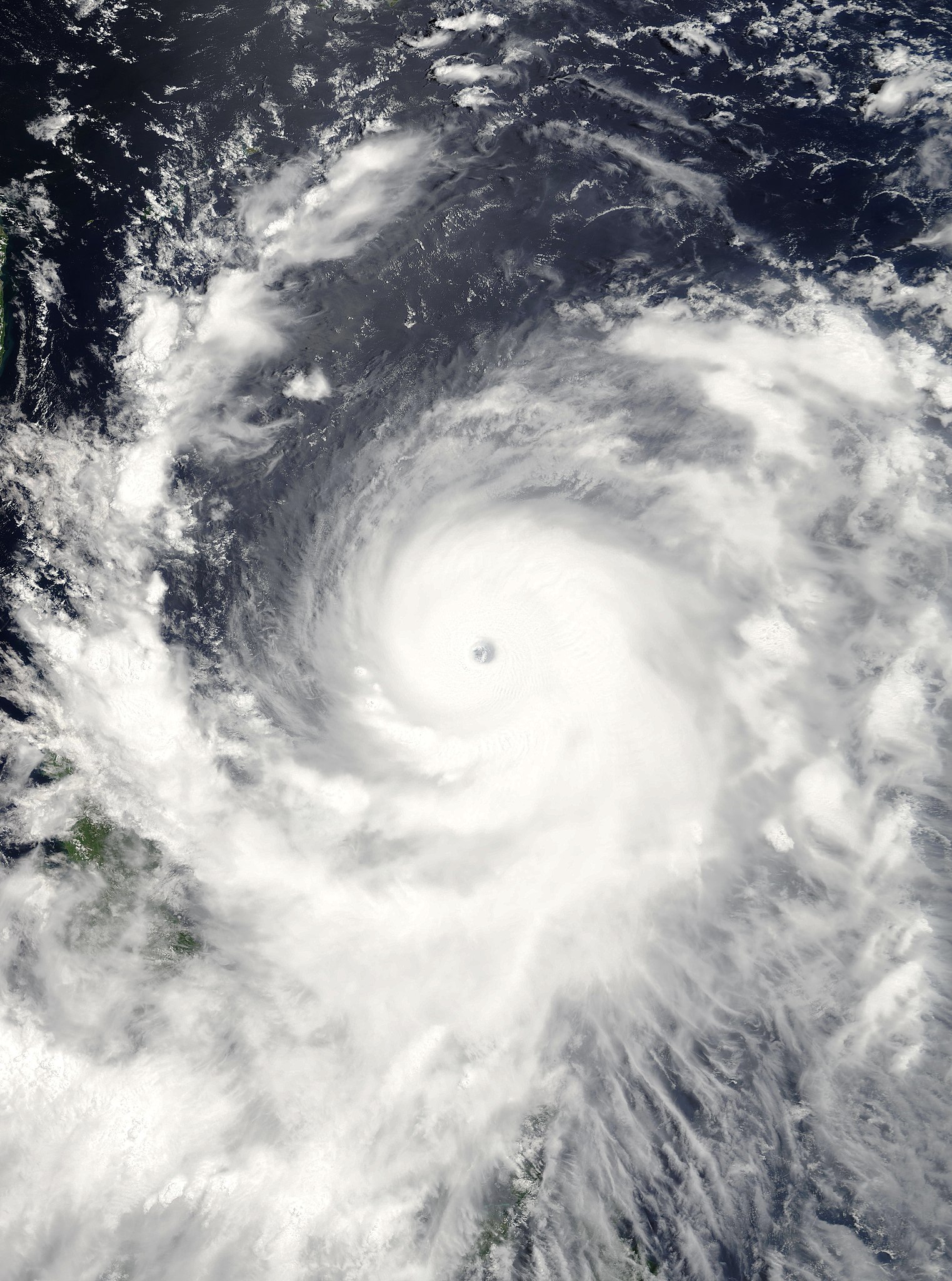
Super Typhoon Sepat came ashore in Taiwan on August 17, 2007, after bringing torrential rain and flooding to the Philippines the day before. Flights to and from Tapei, the island’s capital, were canceled and Chinese authorities were calling all ships at sea to come back to shore in anticipation of the powerful typhoon crossing the Taiwan Strait and coming ashore on the mainland, said news reports. The typhoon was classified as Category Five typhoon, at the very top of the scale, with sustained winds of 184 kilometers per hour (114 miles per hour), according to CNN. At 10:25 a.m. local time (02:25 UTC) on August 16, 2007, when the Moderate Resolution Imaging Spectroradiometer (MODIS) on NASA’s Terra satellite captured this image, Super Typhoon Sepat was still well away from its coming encounter with the Philippines and Taiwan. Winds were measured at a sustained speed as high as 257 km/hr (161 mph) at the time of this image, according to the University of Hawaii’s Tropical Storm Information Center. The storm’s strength is evident in this image from its large size, well-defined spiral structure, and obvious large eye. Some clouds are present in the central eye: a completely clear eye is a tell-tale sign of the most powerful storms, though some clouds can be present in the eye of a powerful storm as is the case here. |
|||||
| Ji̍t-kî | ||||||
| Chhut-chhù | http://earthobservatory.nasa.gov/NaturalHazards/natural_hazards_v2.php3?img_id=14447 | |||||
| Chok-chiá | NASA image by Jesse Allen, using data provided courtesy of the MODIS Rapid Response team at Goddard Space Flight Center. | |||||
| 授權允准 (Bô siŏh-huòi sāi ciā ùng-giông) |
|

Tóng-àn le̍k-sú
Chhi̍h ji̍t-kî/sî-kan, khoàⁿ hit sî-chūn--ê tóng-àn.
| Ji̍t-kî/Sî-kan | Sáuk-liŏk-dù | Chióh-cháung | Iōng-chiá | Chù-kái | |
|---|---|---|---|---|---|
| hiān-chāi | 2020-nî 11-goe̍h 5-ji̍t (pài-sì) 01:40 | | 5,800 × 7,800(5.51 MB) | FleurDeOdile | dimensions |
| 2013-nî 2-goe̍h 6-ji̍t (pài-saⁿ) 05:16 |  | 8,437 × 10,801(18.01 MB) | Earth100 | Best Image, in higher resolution, showing the whole storm system's roaring size. | |
| 2007-nî 8-goe̍h 17-ji̍t (pài-gō·) 18:55 |  | 6,000 × 6,000(3.42 MB) | Good kitty | == Summary == {{Information |Description=Super Typhoon Sepat came ashore in Taiwan on August 17, 2007, after bringing torrential rain and flooding to the Philippines the day before. Flights to and from Tapei, the island’s capital, were canceled and Chin |
Iáⁿ-siōng liân-kiat
Í-hā ê ia̍h liân kàu chit ê iáⁿ-siōng:
tóng-àn hō͘ lâng sái--ê chōng-hóng
Ē-kha--ê kî-thaⁿ wiki ēng tio̍h chit--ê tóng-àn:
- de.wikipedia.org hō͘ lâng ēng--ê chêng-hêng
- en.wikipedia.org hō͘ lâng ēng--ê chêng-hêng
- ja.wikipedia.org hō͘ lâng ēng--ê chêng-hêng
- ko.wikipedia.org hō͘ lâng ēng--ê chêng-hêng
- ms.wikipedia.org hō͘ lâng ēng--ê chêng-hêng
- pt.wikipedia.org hō͘ lâng ēng--ê chêng-hêng
- vi.wikipedia.org hō͘ lâng ēng--ê chêng-hêng
- zh.wikipedia.org hō͘ lâng ēng--ê chêng-hêng