
tóng-àn:Worcestershire UK locator map 2010.svg

此 SVG 檔案的 PNG 預覽的大小:494 × 600 siōng-sò͘。 Kî-thaⁿ--ê kái-sek-tō͘: 198 × 240 siōng-sò͘ | 395 × 480 siōng-sò͘ | 633 × 768 siōng-sò͘ | 843 × 1,024 siōng-sò͘ | 1,687 × 2,048 siōng-sò͘ | 1,108 × 1,345 siōng-sò͘.
Choân kái-sek-tō͘ (SVG ùng-giông, chék-cháung: 1,108 × 1,345 chuông-só, ùng-giông duâi-nâung:302 KB)
|
|
Che sī tùi Wikimedia Commons ín--lâi ê chi̍t hūn tóng-àn. I tī hia ê kì-su̍t-ia̍h téng-bīn ê chu-sìn hián-sī ùi ē-té. |
Khài-iàu
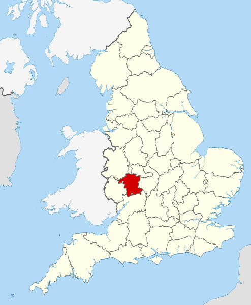
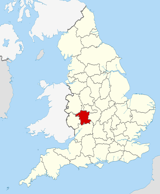
| Soat-bêng | Location of the ceremonial county of Worcestershire within England. |
| Ji̍t-kî | |
| Chhut-chhù |
National Geospatial-Intelligence Agency
|
| Chok-chiá | Nilfanion |
Siū-khoân
我,本作品的著作權持有者,決定用以下授權條款發佈本作品:
此檔案採用創用CC 姓名標示-相同方式分享 3.0 未在地化版本授權條款。
- 你會使自由:
- 分享 – kho͘-pih, hoat-pò͘ kap thoân-pò͘ pún chok
- 重新修改 – kái-pian pún chok-phín
- Àn i-hā ê tiâu-kiāⁿ
- 標示名姓 – 您必須指名出正確的製作者,和提供授權條款的連結,以及表示是否有對內容上做出變更。您可以用任何合理的方式來行動,但不得以任何方式表明授權條款是對您許可或是由您所使用。
- 仝款方式方享 – Lí nā kái-tōng, piàn-khoán, he̍k-chiá kun-kù pún chok chhòng-chō, lí kaⁿ-taⁿ ē-tàng ēng kap pún chok kâng-khoán he̍k-chiá saⁿ-chhiūⁿ ê hí-khó lâi hoat-pò͘ chò--chhut-lâi ê chok-phín.

|
已授權您依據自由軟體基金會發行的無固定段落、封面文字和封底文字GNU自由文件授權條款1.2版或任意後續版本,對本檔進行複製、傳播和/或修改。該協議的副本列在GNU自由文件授權條款中。 |
Nṳ̄ buóh dĭk sié-nó̤h sêu-guòng dèu-kuāng dŭ kō̤-ī gēng.

|
This is one of the images forming part of the Valued image set: Locator maps of the Ceremonial counties of England on Wikimedia Commons. The image set has been assessed under the valued image set criteria and is considered the most valued set on Commons within the scope:
Locator maps of the Ceremonial counties of England
You can see its nomination at Commons:Valued image candidates/Locator maps of English ceremonial counties. |
Tóng-àn le̍k-sú
Chhi̍h ji̍t-kî/sî-kan, khoàⁿ hit sî-chūn--ê tóng-àn.
| Ji̍t-kî/Sî-kan | Sáuk-liŏk-dù | Chióh-cháung | Iōng-chiá | Chù-kái | |
|---|---|---|---|---|---|
| hiān-chāi | 2010-nî 11-goe̍h 23-ji̍t (pài-jī) 22:49 | | 1,108 × 1,345(302 KB) | Nilfanion | == Summary == {{Information |Description=Location of the ceremonial county of Worcestershire within England. |Source=Ordnance Survey [https://www.ordnancesurvey.co.uk/opendatadownload/products.html OpenData]: *Co |
Iáⁿ-siōng liân-kiat
Í-hā ê ia̍h liân kàu chit ê iáⁿ-siōng:
tóng-àn hō͘ lâng sái--ê chōng-hóng
Ē-kha--ê kî-thaⁿ wiki ēng tio̍h chit--ê tóng-àn:
- af.wikipedia.org hō͘ lâng ēng--ê chêng-hêng
- ast.wikipedia.org hō͘ lâng ēng--ê chêng-hêng
- be-tarask.wikipedia.org hō͘ lâng ēng--ê chêng-hêng
- be.wikipedia.org hō͘ lâng ēng--ê chêng-hêng
- bg.wikipedia.org hō͘ lâng ēng--ê chêng-hêng
- ca.wikipedia.org hō͘ lâng ēng--ê chêng-hêng
- ceb.wikipedia.org hō͘ lâng ēng--ê chêng-hêng
- cs.wikipedia.org hō͘ lâng ēng--ê chêng-hêng
- dag.wikipedia.org hō͘ lâng ēng--ê chêng-hêng
- en.wikipedia.org hō͘ lâng ēng--ê chêng-hêng
- Worcestershire
- Stoke Heath, Worcestershire
- Lindridge
- Bordesley, Worcestershire
- Frankley
- Wadborough
- Pinvin
- Areley Kings
- Leigh, Worcestershire
- Wychbury Hill
- Romsley, Worcestershire
- Lickey End
- Hopwood, Worcestershire
- Ryall, Worcestershire
- Holt Heath, Worcestershire
- Lydiate Ash
- Heightington
- Rock, Worcestershire
- Mamble
- Ab Lench
- Abberton, Worcestershire
- Pirton, Worcestershire
- Pensham
- Norton, Worcestershire
- Whittington, Worcestershire
- Midlands Plateau
- Wyre Piddle
- Hill and Moor
- Martin Hussingtree
- Template:Worcestershire-geo-stub
- Aldington, Worcestershire
- Queenhill
- Stockton on Teme
- Ashton under Hill
- Bayton
- Besford
- Bickmarsh
- Birlingham
- Birtsmorton
- Bishampton
檢視此檔案的更多全域使用狀況。