
tóng-àn:Map-Francophone World.png
Seng khoàⁿ chiàm-liōng: 800 × 354 siōng-sò͘. Kî-thaⁿ--ê kái-sek-tō͘: 320 × 142 siōng-sò͘ | 640 × 283 siōng-sò͘ | 1,425 × 631 siōng-sò͘.
Choân kái-sek-tō͘ (1,425 × 631 siōng-sò͘ , tóng-àn chiàm-liōng: 39 KB, MIME luī-hêng: image/png)
|
|
Che sī tùi Wikimedia Commons ín--lâi ê chi̍t hūn tóng-àn. I tī hia ê kì-su̍t-ia̍h téng-bīn ê chu-sìn hián-sī ùi ē-té. |
Khài-iàu
| Soat-bêng |
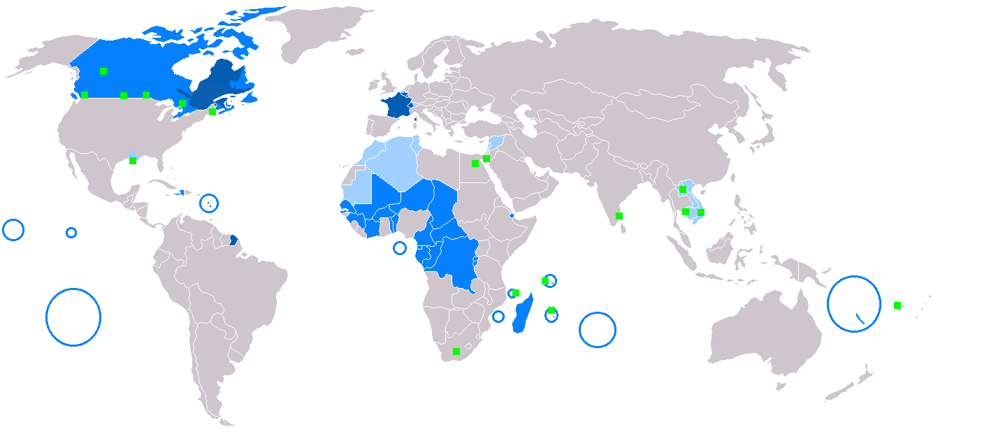
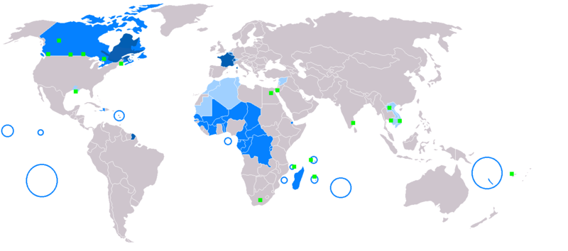
English: Map of Francophone world.
Français : Carte du monde où on parle le français.
Русский: Карта франкоязычного мира.
Nederlands: Het Frans in de wereld.
Suomi: Maailmankartta ranskaa puhuvista maista.
Українська: Мапа франкомовного світу.
日本語: フランス語圏の地図。
中文:说法语的人在世界上的分布情况
Čeština: Mapa frankofonního světa
|
| Caption | English:
administrative language
secondary or non-official language
French-speaking minority Français :
langue maternelle
langue administrative
langue importante, secondaire et/ou de culture
minorités francophones Español:
lengua materna
lengua administrativa
segunda lengua o lengua no oficial
minorías francófonas Deutsch:
Muttersprache
Amtssprache
Nebensprache oder nicht offizielle Sprache
französische Minderheiten Русский:
родной язык
административный язык
важный, второй или язык культуры
франкоязычные меньшинства العربية:
أزرق داكن: اللغة الأم
أزرق:تستعمل في القطاعات الحكومية
أزرق فاتح:لغة ثانوية أو غير رسمية
أخضر فاتح:أقليات تتحدث الفرنسية. Slovenčina:
rodný jazyk
úradný jazyk
druhý alebo neoficiálny jazyk
frankofónna menšina Čeština:
domácí jazyk
správní jazyk
druhotný nebo neoficiální jazyk
frankofonní menšina Esperanto:
gepatra lingvo
administra lingvo
kultura lingvo
franclingvaj minoritatoj Italiano:
lingua madre
lingua amministrativa
seconda lingua o lingua non ufficiale
minoranze francofone Magyar:
anyanyelv
hivatalos nyelv/közigazgatás nyelve
fontos második nyelv vagy kultúrnyelv
franciaajkú kisebbség Nederlands:
moedertaal
bestuurstaal
tweede taal of niet-officiële taal
Franstalige minderheden Norsk bokmål:
Morsmål
Administrativt språk
Andrespråk eller uoffisielt språk
Fransktalende minoriteter Polski:
język ojczysty
język urzędowy
język kultury
w mniejszości Português:
Língua materna
Língua administrativa
Segunda língua ou língua não oficial
Minoria francofônica Română:
limbă maternă
limbă administrativă
Limbă secundară sau neoficială
minorităţi francofone Suomi:
äidinkielenä
hallinnollisena kielenä
kulttuurillisesti merkittävä kieli
ranskankielisiä vähemmistöjä Svenska:
Modersmål
Administrativt språk
Andrahands- eller ickeofficiellt språk
Fransktalande minoriteter Türkçe:
Koyu mavi: Anadil
Mavi: Yönetim dili
Açık mavi: İkinci ya da resmi olmayan dil
Yeşil kareler: Fransızca konuşan azınlıklar Українська:
рідна мова
офіційна мова
друга або неофіційна мова
франкомовні меншини 中文:
深藍:本土語言
藍:行政語言
淺藍:第二或非官方語言
綠色正方形:少數講法語 日本語: (藍) 母語
(青) 公用語
(水色) 第2言語
(緑) 少数言語 |
| Ji̍t-kî | |
| Chhut-chhù |
Incomplete 本檔案衍生自: BlankMap-World.png: |
| Chok-chiá |
|
Siū-khoân
| 此作品已由其作者,Yug,釋出至公有領域。此授權條款在全世界均適用。 這可能在某些國家不合法,如果是的話: |
Tóng-àn le̍k-sú
Chhi̍h ji̍t-kî/sî-kan, khoàⁿ hit sî-chūn--ê tóng-àn.
| Ji̍t-kî/Sî-kan | 細張圖 | 寸尺 | Iōng-chiá | Chù-kái | |
|---|---|---|---|---|---|
| hiān-chāi | 2018-nî 3-goe̍h 9-ji̍t (pài-gō·) 20:20 | | 1,425 × 631(39 KB) | Maphobbyist | South Sudan border |
| 2018-nî 1-goe̍h 23-ji̍t (pài-jī) 12:30 |  | 1,425 × 631(39 KB) | Maphobbyist | Sticking to sources. French is not the majority mother language in Gabon and Ivory coast and in its capital cities. | |
| 2017-nî 4-goe̍h 19-ji̍t (pài-saⁿ) 13:22 |  | 1,425 × 631(39 KB) | Sorkiv | The French language has become native to Gabon and Côte d'Ivoire (Abidjan, Yamoussoukro). | |
| 2015-nî 5-goe̍h 7-ji̍t (pài-sì) 12:53 |  | 1,425 × 631(39 KB) | Zorion | From Hearst (Ontario) to Abitibi, it's a french-speaking zone + Anticosti added + remouved a part of New-Brunswick + francophone in Alberta are located in the Noth-West + Aroostook County in US | |
| 2014-nî 12-goe̍h 11-ji̍t (pài-sì) 17:52 |  | 1,425 × 631(56 KB) | Maphobbyist | In Syria French is a secondary non-official language. | |
| 2014-nî 12-goe̍h 11-ji̍t (pài-sì) 16:57 |  | 1,425 × 631(49 KB) | Maphobbyist | In New Caledonia, French is the sole official language, but it is the mother language of a minority. | |
| 2008-nî 3-goe̍h 6-ji̍t (pài-sì) 17:13 |  | 1,425 × 631(32 KB) | Arctic.gnome | French is administrative in Canada and a secondary language in Andorra. I also added PEI and Manitoulin Island to Canada, and Saint Pierre, Miquelon and Sable islands around the Newfoundland coast. | |
| 2008-nî 3-goe̍h 6-ji̍t (pài-sì) 17:09 |  | 1,425 × 631(50 KB) | Arctic.gnome | Reverted to version as of 20:37, 22 January 2007 | |
| 2008-nî 3-goe̍h 6-ji̍t (pài-sì) 17:08 |  | 1,425 × 631(32 KB) | Arctic.gnome | == Summary == Map of Francophone world. Map made from Image:BlankMap-World.png '''English''' legends: {{legend|#0c5eb1|native language}} {{legend|#0080ff|administrative language}} {{legend|#9fceff|secondary or non-official langua | |
| 2007-nî 1-goe̍h 22-ji̍t (pài-it) 20:37 |  | 1,425 × 631(50 KB) | IAMTHEEGGMAN | Updating actual World Map and Adding Montenegro. |
Iáⁿ-siōng liân-kiat
Í-hā ê ia̍h liân kàu chit ê iáⁿ-siōng:
tóng-àn hō͘ lâng sái--ê chōng-hóng
Ē-kha--ê kî-thaⁿ wiki ēng tio̍h chit--ê tóng-àn:
- de.wikipedia.org hō͘ lâng ēng--ê chêng-hêng
- en.wikipedia.org hō͘ lâng ēng--ê chêng-hêng
- fr.wikipedia.org hō͘ lâng ēng--ê chêng-hêng
- fr.wiktionary.org hō͘ lâng ēng--ê chêng-hêng
- he.wikivoyage.org hō͘ lâng ēng--ê chêng-hêng
- it.wikipedia.org hō͘ lâng ēng--ê chêng-hêng
- it.wiktionary.org hō͘ lâng ēng--ê chêng-hêng
- no.wiktionary.org hō͘ lâng ēng--ê chêng-hêng