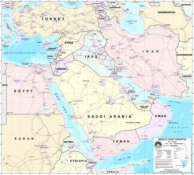
tóng-àn:Middle east graphic 2003.jpg

Seng khoàⁿ chiàm-liōng: 664 × 600 siōng-sò͘. Kî-thaⁿ--ê kái-sek-tō͘: 266 × 240 siōng-sò͘ | 532 × 480 siōng-sò͘ | 850 × 768 siōng-sò͘ | 1,134 × 1,024 siōng-sò͘ | 2,268 × 2,048 siōng-sò͘ | 2,973 × 2,685 siōng-sò͘.
Choân kái-sek-tō͘ (2,973 × 2,685 siōng-sò͘ , tóng-àn chiàm-liōng: 3.91 MB, MIME luī-hêng: image/jpeg)
Tóng-àn le̍k-sú
Chhi̍h ji̍t-kî/sî-kan, khoàⁿ hit sî-chūn--ê tóng-àn.
| Ji̍t-kî/Sî-kan | Sáuk-liŏk-dù | Chióh-cháung | Iōng-chiá | Chù-kái | |
|---|---|---|---|---|---|
| hiān-chāi | 2012-nî 2-goe̍h 8-ji̍t (pài-saⁿ) 22:30 |  | 2,973 × 2,685(3.91 MB) | M0tty | Remove compression artefacts by a bilateral filtering. |
| 2006-nî 7-goe̍h 14-ji̍t (pài-gō·) 21:43 |  | 2,973 × 2,685(1,013 KB) | Unquietwiki | ''Courtesy of the University of Texas Libraries, The University of Texas at Austin'' [http://www.lib.utexas.edu/maps/middle_east.html http://www.lib.utexas.edu/maps/middle_east.html] High-resolution political / railway / roadmap of the Middle East. |
Iáⁿ-siōng liân-kiat
Í-hā ê ia̍h liân kàu chit ê iáⁿ-siōng:
tóng-àn hō͘ lâng sái--ê chōng-hóng
Ē-kha--ê kî-thaⁿ wiki ēng tio̍h chit--ê tóng-àn:
- ar.wikipedia.org hō͘ lâng ēng--ê chêng-hêng
- ويكيبيديا:قوالب/بذور
- ويكيبيديا:قوالب/بذور/جدول بذرة 1
- قالب:بذرة جغرافيا الشرق الأوسط
- بادية الشام
- محافظة العاصمة (البحرين)
- خليج عدن
- دزفول
- زاغروس
- مسجد سليمان
- زاينده
- مسرح أحداث الشرق الأوسط خلال الحرب العالمية الثانية
- الحويزة (مدينة)
- قائمة جزر الخليج العربي
- شرق المتوسط
- قائمة نزاعات الشرق الأوسط الحديثة
- مستخدم:Adnanzoom/مساعدات
- عبد الله بن سعيد
- قرار مجلس الأمن التابع للأمم المتحدة رقم 1381
- مستخدم:ASammour/بذرة-بوابة
- شرف الدين بن الحسن
- فخر الدين بن عدي
- صخر بن صخر بن مسافر
- قالب:بذرة أعلام الشرق الأوسط
- أبجر التاسع
- arz.wikipedia.org hō͘ lâng ēng--ê chêng-hêng
- ba.wikipedia.org hō͘ lâng ēng--ê chêng-hêng
- bn.wikipedia.org hō͘ lâng ēng--ê chêng-hêng
- ca.wikipedia.org hō͘ lâng ēng--ê chêng-hêng
- ce.wikipedia.org hō͘ lâng ēng--ê chêng-hêng
- ckb.wikipedia.org hō͘ lâng ēng--ê chêng-hêng
- el.wikipedia.org hō͘ lâng ēng--ê chêng-hêng
- en.wikipedia.org hō͘ lâng ēng--ê chêng-hêng
檢視此檔案的更多全域使用狀況。


