
tóng-àn:1730 Ottens Map of Persia (Iran, Iraq, Turkey) - Geographicus - RegnumPersicum-ottens-1730.jpg
Seng khoàⁿ chiàm-liōng: 800 × 455 siōng-sò͘. Kî-thaⁿ--ê kái-sek-tō͘: 320 × 182 siōng-sò͘ | 640 × 364 siōng-sò͘ | 1,024 × 583 siōng-sò͘ | 1,280 × 728 siōng-sò͘ | 2,560 × 1,457 siōng-sò͘ | 5,000 × 2,845 siōng-sò͘.
Choân kái-sek-tō͘ (5,000 × 2,845 siōng-sò͘ , tóng-àn chiàm-liōng: 3.6 MB, MIME luī-hêng: image/jpeg)
|
|
Che sī tùi Wikimedia Commons ín--lâi ê chi̍t hūn tóng-àn. I tī hia ê kì-su̍t-ia̍h téng-bīn ê chu-sìn hián-sī ùi ē-té. |
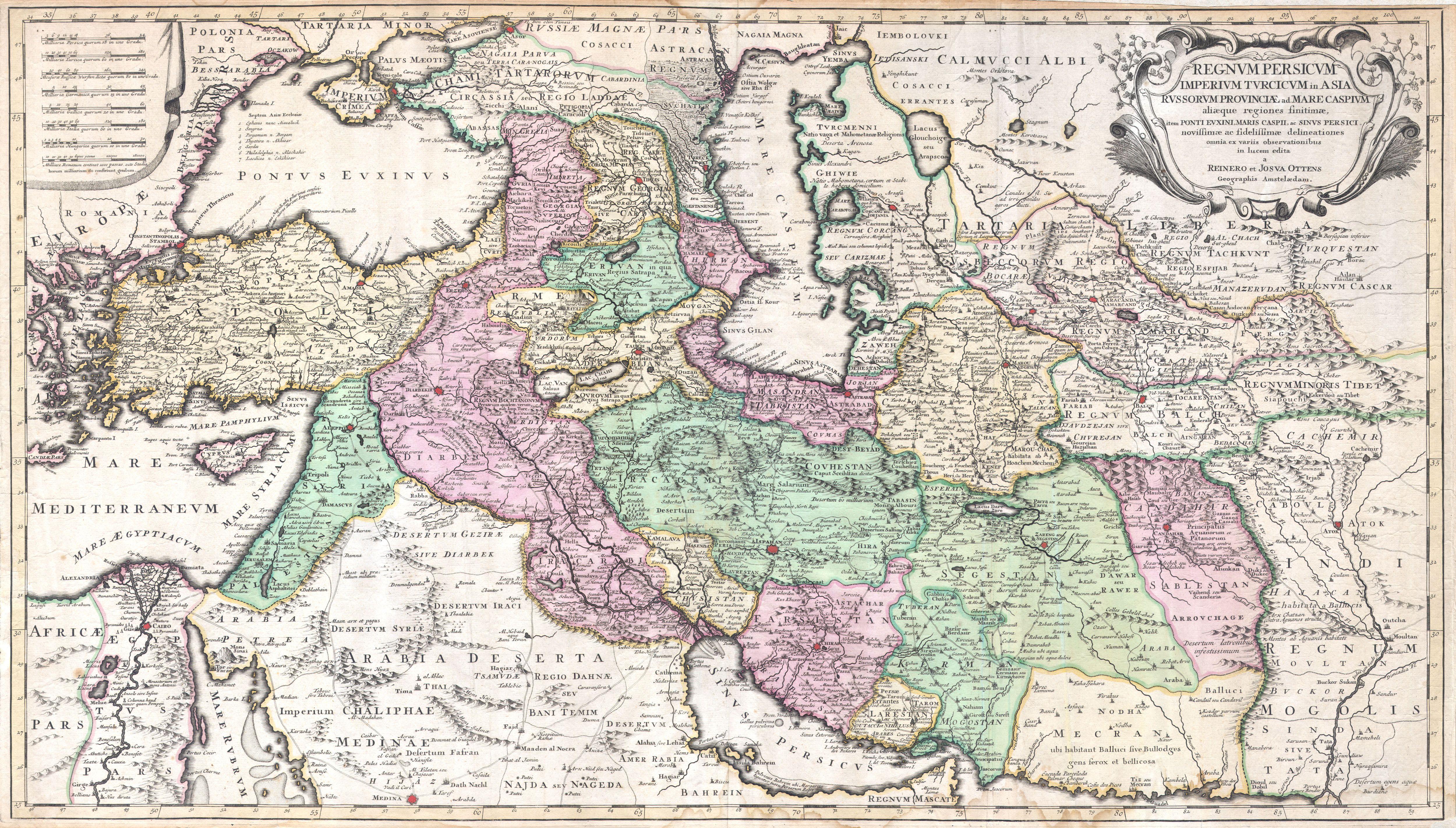
| Regnum Persicum Imperium Turcicum in Asia Russorum Provinciae and Mare Caspium. | ||||||
|---|---|---|---|---|---|---|
| 作家 | ||||||
| 標題 |
Regnum Persicum Imperium Turcicum in Asia Russorum Provinciae and Mare Caspium. |
|||||
| Soat-bêng |
English: A scarce and altogether spectacular c. 1730 map of southwestern Asia, specifically focusing on Persia, by Reiner and Joshua Ottens. Covers from Egypt and Greece eastward to include Turkey, the northern part of the Arabian Peninsula, the Black and Caspian Seas, Persia, and Tartary, Afghanistan and Pakistan, including the Indus valley and the western extant of the Mogul Empire. Extends as far north as Asof (Asov) and “Tibet”, and as far south as Medina. Includes superb detail regarding the early 18th century Silk Route trading routes through Persia and Central Asia, noting the important centers of Samarkand, Bukhara and Tashkent. Generally accurate with only a few notable flaws. Most specifically the positioning of Lake Van and Lake Chahi in close proximity to one another. These lakes are in fact separated by over 160 kilometers. Identifies the Pyramids of Egypt, the ruins of Troy, Mt. Sinai, and Mt. Agerdaghi (Mt. Ararat, but labeled Mt. Noah). Upper right quadrant features an attractive title cartouche with baroque ornamentation. Upper left quadrant has eight distance scales on a curtain. |
|||||
| Ji̍t-kî | 約1730年(undated) | |||||
| 尺寸 | 高度: 20英寸(50.8厘米); 寬度: 35英寸(88.9厘米) | |||||
| 登錄號 |
Geographicus link: RegnumPersicum-ottens-1730 |
|||||
| 來源/攝影者 |
Independent Issue.
|
|||||
| 授權允准 (Bô siŏh-huòi sāi ciā ùng-giông) |
|
|||||
| 其他版本 | ||||||
_-_Geographicus_-_RegnumPersicum-ottens-1730_(Mecran).jpg)
_-_Geographicus_-_RegnumPersicum-ottens-1730.jpg)
| 註解 | 該圖片含有註解:在維基媒體共享資源上查看註解 |
Tóng-àn le̍k-sú
Chhi̍h ji̍t-kî/sî-kan, khoàⁿ hit sî-chūn--ê tóng-àn.
| Ji̍t-kî/Sî-kan | Sáuk-liŏk-dù | Chióh-cháung | Iōng-chiá | Chù-kái | |
|---|---|---|---|---|---|
| hiān-chāi | 2011-nî 3-goe̍h 16-ji̍t (pài-saⁿ) 16:00 | | 5,000 × 2,845(3.6 MB) | BotMultichill | {{subst:User:Multichill/Geographicus |link=http://www.geographicus.com/P/AntiqueMap/RegnumPersicum-ottens-1730 |product_name=1730 Ottens Map of Persia (Iran, Iraq, Turkey) |map_title=Regnum Persicum Imperium Turcicum in Asia Russorum Provinciae and Mare C |
Iáⁿ-siōng liân-kiat
Í-hā ê ia̍h liân kàu chit ê iáⁿ-siōng:
tóng-àn hō͘ lâng sái--ê chōng-hóng
Ē-kha--ê kî-thaⁿ wiki ēng tio̍h chit--ê tóng-àn:
- ar.wikipedia.org hō͘ lâng ēng--ê chêng-hêng
- azb.wikipedia.org hō͘ lâng ēng--ê chêng-hêng
- az.wikipedia.org hō͘ lâng ēng--ê chêng-hêng
- bs.wikipedia.org hō͘ lâng ēng--ê chêng-hêng
- ca.wikipedia.org hō͘ lâng ēng--ê chêng-hêng
- da.wikipedia.org hō͘ lâng ēng--ê chêng-hêng
- de.wikipedia.org hō͘ lâng ēng--ê chêng-hêng
- el.wikipedia.org hō͘ lâng ēng--ê chêng-hêng
- en.wikipedia.org hō͘ lâng ēng--ê chêng-hêng
- es.wikipedia.org hō͘ lâng ēng--ê chêng-hêng
- et.wikipedia.org hō͘ lâng ēng--ê chêng-hêng
- fa.wikipedia.org hō͘ lâng ēng--ê chêng-hêng
- hr.wikipedia.org hō͘ lâng ēng--ê chêng-hêng
- hy.wikipedia.org hō͘ lâng ēng--ê chêng-hêng
- it.wikipedia.org hō͘ lâng ēng--ê chêng-hêng
- ka.wikipedia.org hō͘ lâng ēng--ê chêng-hêng
- ko.wikipedia.org hō͘ lâng ēng--ê chêng-hêng
- mk.wikipedia.org hō͘ lâng ēng--ê chêng-hêng
- ms.wikipedia.org hō͘ lâng ēng--ê chêng-hêng
- nl.wikipedia.org hō͘ lâng ēng--ê chêng-hêng
- pnb.wikipedia.org hō͘ lâng ēng--ê chêng-hêng
- pt.wikipedia.org hō͘ lâng ēng--ê chêng-hêng
- ru.wikipedia.org hō͘ lâng ēng--ê chêng-hêng
- sh.wikipedia.org hō͘ lâng ēng--ê chêng-hêng
- sr.wikipedia.org hō͘ lâng ēng--ê chêng-hêng
檢視此檔案的更多全域使用狀況。
_-_Geographicus_-_RegnumPersicum-ottens-1730.jpg)
_-_Geographicus_-_RegnumPersicum-ottens-1730.jpg)