
tóng-àn:2002 Winter Olympics torch relay route.svg

此 SVG 檔案的 PNG 預覽的大小:800 × 495 siōng-sò͘。 Kî-thaⁿ--ê kái-sek-tō͘: 320 × 198 siōng-sò͘ | 640 × 396 siōng-sò͘ | 1,024 × 633 siōng-sò͘ | 1,280 × 791 siōng-sò͘ | 2,560 × 1,583 siōng-sò͘ | 959 × 593 siōng-sò͘.
Choân kái-sek-tō͘ (SVG ùng-giông, chék-cháung: 959 × 593 chuông-só, ùng-giông duâi-nâung:155 KB)
|
|
Che sī tùi Wikimedia Commons ín--lâi ê chi̍t hūn tóng-àn. I tī hia ê kì-su̍t-ia̍h téng-bīn ê chu-sìn hián-sī ùi ē-té. |
Khài-iàu
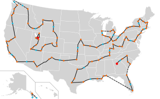
| Soat-bêng | The route of the 2002 Winter Olympics torch relay. The starting and ending points are marked with large red dots, while major stops along the route are marked with smaller orange dots. The blue arrows indicate the direction of travel along the route, which is marked by the black lines. |
| Ji̍t-kî | (UTC) |
| Chhut-chhù | Ka-tī chò--ê (Original text: Self-made with information from Wikipedia and using Blank_US_Map.svg) |
| Chok-chiá | Mangoman88, using Blank_US_Map.svg by Theshibboleth |
| 其他版本 |
|
Siū-khoân
| 此檔案採用創用CC 姓名標示-相同方式分享 3.0 未在地化版本授權條款。 | ||
| Biĕu-sê miàng-sáng: Mangoman88, using Blank_US_Map.svg by Theshibboleth | ||
| ||
| 已新增授權條款標題至此檔案,作為GFDL授權更新的一部份。 |

|
已授權您依據自由軟體基金會發行的無固定段落、封面文字和封底文字GNU自由文件授權條款1.2版或任意後續版本,對本檔進行複製、傳播和/或修改。該協議的副本列在GNU自由文件授權條款中。 |
Nṳ̄ buóh dĭk sié-nó̤h sêu-guòng dèu-kuāng dŭ kō̤-ī gēng.
原始上傳日誌
This image is a derivative work of the following images:
- File:Blank_US_Map.svg licensed with Cc-by-sa-3.0-migrated, GFDL
- 2009-11-05T19:44:02Z NuclearVacuum 959x593 (91518 Bytes) minor fix from previous upload
- 2009-11-05T19:39:42Z NuclearVacuum 959x593 (88399 Bytes) Fixed up the borders so they are connected with each state and loosing that gap between them.
- 2008-10-09T16:36:40Z Howcheng 959x593 (80121 Bytes) Reverted to version as of 08:32, 14 June 2007
- 2008-03-12T00:20:02Z AMK1211 959x593 (174744 Bytes) Added borders: Light blue for water borders and black for land borders (international borders thicker).
- 2007-06-14T08:32:47Z Fibonacci 959x593 (80121 Bytes) Optimised code.
- 2006-07-12T23:00:30Z Theshibboleth 959x593 (90537 Bytes) The line framework around Alaska and Hawaii has been pushed a bit
- 2006-07-12T06:35:19Z Theshibboleth 959x593 (89828 Bytes) added DC
- 2006-07-12T06:05:05Z Theshibboleth 959x593 (89649 Bytes) {{Information |Description=A blank map of the United States in scalable vector form. |Source=Own work, based on [[:Image:Electorial map.svg]], inspired by [[:Image:BlankMap-World.png]] |Date=11 July 2006 |Author=[[User:Theshi
Uploaded with derivativeFX
Tóng-àn le̍k-sú
Chhi̍h ji̍t-kî/sî-kan, khoàⁿ hit sî-chūn--ê tóng-àn.
| Ji̍t-kî/Sî-kan | Sáuk-liŏk-dù | Chióh-cháung | Iōng-chiá | Chù-kái | |
|---|---|---|---|---|---|
| hiān-chāi | 2011-nî 1-goe̍h 6-ji̍t (pài-sì) 23:20 | | 959 × 593(155 KB) | Mangoman88 | {{Information |Description=The route of the 2002 Winter Olympics torch relay. The starting and ending points are marked with large red dots, while major stops along the route are marked with smaller orange dots. The blue arrows indicate the direction of t |
Iáⁿ-siōng liân-kiat
Bô poàⁿ ia̍h liân kàu chit tiuⁿ iáⁿ-siōng.
tóng-àn hō͘ lâng sái--ê chōng-hóng
Ē-kha--ê kî-thaⁿ wiki ēng tio̍h chit--ê tóng-àn:
- de.wikipedia.org hō͘ lâng ēng--ê chêng-hêng
- en.wikipedia.org hō͘ lâng ēng--ê chêng-hêng
- fr.wikipedia.org hō͘ lâng ēng--ê chêng-hêng
- sv.wikipedia.org hō͘ lâng ēng--ê chêng-hêng
- th.wikipedia.org hō͘ lâng ēng--ê chêng-hêng