
tóng-àn:Boundaries of the Okinawan Languages.svg

此 SVG 檔案的 PNG 預覽的大小:736 × 600 siōng-sò͘。 Kî-thaⁿ--ê kái-sek-tō͘: 295 × 240 siōng-sò͘ | 589 × 480 siōng-sò͘ | 942 × 768 siōng-sò͘ | 1,257 × 1,024 siōng-sò͘ | 2,513 × 2,048 siōng-sò͘.
Choân kái-sek-tō͘ (SVG ùng-giông, chék-cháung: 800 × 652 chuông-só, ùng-giông duâi-nâung:21 KB)
|
|
Che sī tùi Wikimedia Commons ín--lâi ê chi̍t hūn tóng-àn. I tī hia ê kì-su̍t-ia̍h téng-bīn ê chu-sìn hián-sī ùi ē-té. |
Khài-iàu
| Soat-bêng |
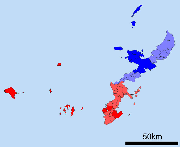
English: A map of the Okinawan Islands displaying the distribution of the Northern Okinawan Language (Kunigami) in blue, and the South-Central Okinawan Language (Shuri-Naha) in red. The darker areas represent regions that have been officially classified by the following sources:
|
| Ji̍t-kî | (UTC) |
| Chhut-chhù | Map_of_Okinawa_Prefecture_Ja.svg |
| Chok-chiá |
|
| 這是一張修飾過的圖片,即本圖片是用軟體修改過後的版本,修改的方式或內容有:Removed the Daito, Yaeyama, Miyako and Yonaguni islands. Changed all the links to point towards their English Wikipedia counterparts. Changed the colours on the map to demonstrate the Okinawan language boundaries.。原版圖片來源:Map of Okinawa Prefecture Ja.svg。修改者:Io Katai。
|
Siū-khoân
我,本作品的著作權持有者,決定用以下授權條款發佈本作品:
| 此檔案採用創用CC 姓名標示-相同方式分享 3.0 未在地化版本授權條款。 | ||
| ||
| 已新增授權條款標題至此檔案,作為GFDL授權更新的一部份。 |

|
已授權您依據自由軟體基金會發行的無固定段落、封面文字和封底文字GNU自由文件授權條款1.2版或任意後續版本,對本檔進行複製、傳播和/或修改。該協議的副本列在GNU自由文件授權條款中。 |
Nṳ̄ buóh dĭk sié-nó̤h sêu-guòng dèu-kuāng dŭ kō̤-ī gēng.
原始上傳日誌
This image is a derivative work of the following images:
- File:Map_of_Okinawa_Prefecture_Ja.svg licensed with Cc-by-sa-3.0-migrated, GFDL
- 2008-04-30T00:12:31Z Krisgrotius 800x652 (14670 Bytes) {{Information| |Description= Map of Okinawa Prefecture, Japan. |Source= Japanese wiki [http://ja.wikipedia.org/wiki/%E7%94%BB%E5%83%8F:%E5%8C%85%E6%8B%AC%E8%87%AA%E6%B2%BB%E4%BD%93%E5%8C%BA%E7%94%BB%E5%9B%B3_47000.svg] |Da
Uploaded with derivativeFX
Tóng-àn le̍k-sú
Chhi̍h ji̍t-kî/sî-kan, khoàⁿ hit sî-chūn--ê tóng-àn.
| Ji̍t-kî/Sî-kan | Sáuk-liŏk-dù | Chióh-cháung | Iōng-chiá | Chù-kái | |
|---|---|---|---|---|---|
| hiān-chāi | 2010-nî 12-goe̍h 25-ji̍t (pài-la̍k) 00:49 | | 800 × 652(21 KB) | Io Katai | fixed links |
| 2010-nî 12-goe̍h 25-ji̍t (pài-la̍k) 00:47 |  | 800 × 652(21 KB) | Io Katai | Missed out on a few links | |
| 2010-nî 12-goe̍h 25-ji̍t (pài-la̍k) 00:41 |  | 800 × 652(21 KB) | Io Katai | {{Information |Description=A map of the Okinawan Islands displaying the distribution of the Northern Okinawan Language (Kunigami) in blue, and the South-Central Okinawan Language (Shuri-Naha) in red. The darker areas represent regions that have been offic |
Iáⁿ-siōng liân-kiat
Í-hā ê ia̍h liân kàu chit ê iáⁿ-siōng:
tóng-àn hō͘ lâng sái--ê chōng-hóng
Ē-kha--ê kî-thaⁿ wiki ēng tio̍h chit--ê tóng-àn:
- ca.wikipedia.org hō͘ lâng ēng--ê chêng-hêng
- cdo.wikipedia.org hō͘ lâng ēng--ê chêng-hêng
- cs.wikipedia.org hō͘ lâng ēng--ê chêng-hêng
- en.wikipedia.org hō͘ lâng ēng--ê chêng-hêng
- et.wikipedia.org hō͘ lâng ēng--ê chêng-hêng
- fa.wikipedia.org hō͘ lâng ēng--ê chêng-hêng
- fi.wikipedia.org hō͘ lâng ēng--ê chêng-hêng
- gd.wikipedia.org hō͘ lâng ēng--ê chêng-hêng
- gl.wikipedia.org hō͘ lâng ēng--ê chêng-hêng
- gn.wikipedia.org hō͘ lâng ēng--ê chêng-hêng
- haw.wikipedia.org hō͘ lâng ēng--ê chêng-hêng
- hu.wikipedia.org hō͘ lâng ēng--ê chêng-hêng
- id.wikipedia.org hō͘ lâng ēng--ê chêng-hêng
- incubator.wikimedia.org hō͘ lâng ēng--ê chêng-hêng
- it.wikipedia.org hō͘ lâng ēng--ê chêng-hêng
- ja.wikipedia.org hō͘ lâng ēng--ê chêng-hêng
- ko.wikipedia.org hō͘ lâng ēng--ê chêng-hêng
- ms.wikipedia.org hō͘ lâng ēng--ê chêng-hêng
- pt.wikipedia.org hō͘ lâng ēng--ê chêng-hêng
- ru.wikipedia.org hō͘ lâng ēng--ê chêng-hêng
- sc.wikipedia.org hō͘ lâng ēng--ê chêng-hêng
- simple.wikipedia.org hō͘ lâng ēng--ê chêng-hêng
- sr.wikipedia.org hō͘ lâng ēng--ê chêng-hêng
- sv.wikipedia.org hō͘ lâng ēng--ê chêng-hêng
- th.wikipedia.org hō͘ lâng ēng--ê chêng-hêng
- tr.wikipedia.org hō͘ lâng ēng--ê chêng-hêng
- uk.wikipedia.org hō͘ lâng ēng--ê chêng-hêng
- vi.wikipedia.org hō͘ lâng ēng--ê chêng-hêng
- zh.wikipedia.org hō͘ lâng ēng--ê chêng-hêng