
tóng-àn:Cochise County Incorporated and Unincorporated areas Sierra Vista highlighted.svg

此 SVG 檔案的 PNG 預覽的大小:800 × 565 siōng-sò͘。 Kî-thaⁿ--ê kái-sek-tō͘: 320 × 226 siōng-sò͘ | 640 × 452 siōng-sò͘ | 1,024 × 723 siōng-sò͘ | 1,280 × 904 siōng-sò͘ | 2,560 × 1,807 siōng-sò͘.
Choân kái-sek-tō͘ (SVG ùng-giông, chék-cháung: 850 × 600 chuông-só, ùng-giông duâi-nâung:50 KB)
|
|
Che sī tùi Wikimedia Commons ín--lâi ê chi̍t hūn tóng-àn. I tī hia ê kì-su̍t-ia̍h téng-bīn ê chu-sìn hián-sī ùi ē-té. |
Khài-iàu
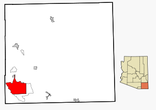
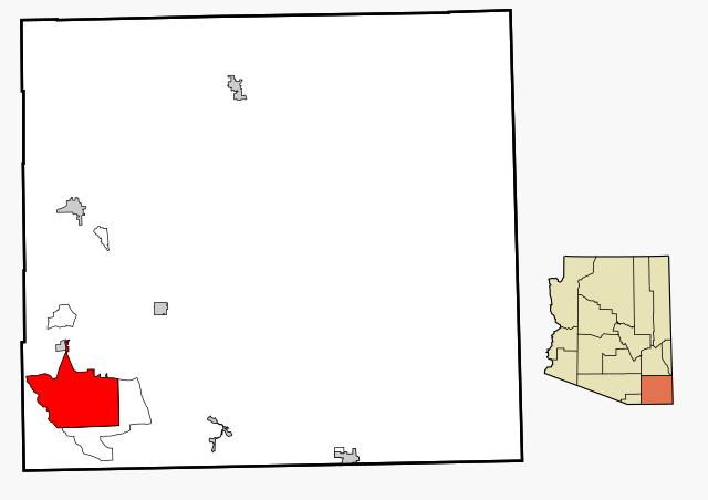
| Soat-bêng | This map shows the incorporated areas and unincorporated areas in Cochise County, Arizona. Sierra Vista is highlighted in red. Incorporated cities are shown in gray and unincorporated communities or CDPs are shown in white. Data for the borders and locations are based on files from the SouthEastern Arizona Governments Organization HPMS Maps and Records and maps from the US Census Bureau TIGER Map Server. I created this map in Inkscape. |
| Ji̍t-kî | |
| Chhut-chhù | My own work, based on public domain information |
| Chok-chiá | Ixnayonthetimmay |
| 授權允准 (Bô siŏh-huòi sāi ciā ùng-giông) |
Copyleft-type licensing. See below. |
| 其他版本 | See Category:Maps of Cochise County for other versions of this image. |
Siū-khoân
| 我,此作品的版權所有人,釋出此作品至公共領域。此授權條款在全世界均適用。 這可能在某些國家不合法,如果是的話: 我授予任何人有權利使用此作品於任何用途,除受法律約束外,不受任何限制。 |
Tóng-àn le̍k-sú
Chhi̍h ji̍t-kî/sî-kan, khoàⁿ hit sî-chūn--ê tóng-àn.
| Ji̍t-kî/Sî-kan | Sáuk-liŏk-dù | Chióh-cháung | Iōng-chiá | Chù-kái | |
|---|---|---|---|---|---|
| hiān-chāi | 2007-nî 2-goe̍h 27-ji̍t (pài-jī) 18:18 | | 850 × 600(50 KB) | Ixnayonthetimmay | {{Information |Description=This map shows the incorporated areas and unincorporated areas in Cochise County, Arizona. [[:en:Sierra Vista, Arizona|Sierra Vista |
Iáⁿ-siōng liân-kiat
Í-hā ê ia̍h liân kàu chit ê iáⁿ-siōng:
tóng-àn hō͘ lâng sái--ê chōng-hóng
Ē-kha--ê kî-thaⁿ wiki ēng tio̍h chit--ê tóng-àn:
- ar.wikipedia.org hō͘ lâng ēng--ê chêng-hêng
- arz.wikipedia.org hō͘ lâng ēng--ê chêng-hêng
- ca.wikipedia.org hō͘ lâng ēng--ê chêng-hêng
- ceb.wikipedia.org hō͘ lâng ēng--ê chêng-hêng
- cy.wikipedia.org hō͘ lâng ēng--ê chêng-hêng
- da.wikipedia.org hō͘ lâng ēng--ê chêng-hêng
- de.wikipedia.org hō͘ lâng ēng--ê chêng-hêng
- eu.wikipedia.org hō͘ lâng ēng--ê chêng-hêng
- fa.wikipedia.org hō͘ lâng ēng--ê chêng-hêng
- fr.wikipedia.org hō͘ lâng ēng--ê chêng-hêng
- ga.wikipedia.org hō͘ lâng ēng--ê chêng-hêng
- ht.wikipedia.org hō͘ lâng ēng--ê chêng-hêng
- hu.wikipedia.org hō͘ lâng ēng--ê chêng-hêng
- ja.wikipedia.org hō͘ lâng ēng--ê chêng-hêng
- mrj.wikipedia.org hō͘ lâng ēng--ê chêng-hêng
- pt.wikipedia.org hō͘ lâng ēng--ê chêng-hêng
- sr.wikipedia.org hō͘ lâng ēng--ê chêng-hêng
- tt.wikipedia.org hō͘ lâng ēng--ê chêng-hêng
- ur.wikipedia.org hō͘ lâng ēng--ê chêng-hêng
- vo.wikipedia.org hō͘ lâng ēng--ê chêng-hêng
- www.wikidata.org hō͘ lâng ēng--ê chêng-hêng