
tóng-àn:Collin County Texas Incorporated Areas Anna highlighted.svg

此 SVG 檔案的 PNG 預覽的大小:800 × 364 siōng-sò͘。 Kî-thaⁿ--ê kái-sek-tō͘: 320 × 145 siōng-sò͘ | 640 × 291 siōng-sò͘ | 1,024 × 465 siōng-sò͘ | 1,280 × 582 siōng-sò͘ | 2,560 × 1,164 siōng-sò͘ | 1,100 × 500 siōng-sò͘.
Choân kái-sek-tō͘ (SVG ùng-giông, chék-cháung: 1,100 × 500 chuông-só, ùng-giông duâi-nâung:292 KB)
|
|
Che sī tùi Wikimedia Commons ín--lâi ê chi̍t hūn tóng-àn. I tī hia ê kì-su̍t-ia̍h téng-bīn ê chu-sìn hián-sī ùi ē-té. |
Khài-iàu
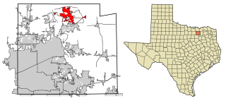
| Soat-bêng | This map shows the incorporated areas in Collin County, Texas. Anna is highlighted in red. I created it in Inkscape using data from the Collin County GIS Website ([1]) and the North Central Texas Council of Governments Website ([2]). |
| Ji̍t-kî | |
| Chhut-chhù | My own work, based on government information. Though I strove to be as accurate in the detail as possible, the information isn't one hundred percent accurate. |
| Chok-chiá | Ixnayonthetimmay |
| 授權允准 (Bô siŏh-huòi sāi ciā ùng-giông) |
Public Domain |
| 其他版本 | See Category:Maps of Collin County, Texas for other versions of this image. |
Siū-khoân
| 我,此作品的版權所有人,釋出此作品至公共領域。此授權條款在全世界均適用。 這可能在某些國家不合法,如果是的話: 我授予任何人有權利使用此作品於任何用途,除受法律約束外,不受任何限制。 |
Tóng-àn le̍k-sú
Chhi̍h ji̍t-kî/sî-kan, khoàⁿ hit sî-chūn--ê tóng-àn.
| Ji̍t-kî/Sî-kan | Sáuk-liŏk-dù | Chióh-cháung | Iōng-chiá | Chù-kái | |
|---|---|---|---|---|---|
| hiān-chāi | 2008-nî 2-goe̍h 14-ji̍t (pài-sì) 00:34 | | 1,100 × 500(292 KB) | Ixnayonthetimmay | == Summary == {{Information |Description=This map shows the incorporated areas in Collin County, Texas. Anna is highlighted in red. I created it in [[:en:Inkscape|Inkscape |
Iáⁿ-siōng liân-kiat
Í-hā ê ia̍h liân kàu chit ê iáⁿ-siōng:
tóng-àn hō͘ lâng sái--ê chōng-hóng
Ē-kha--ê kî-thaⁿ wiki ēng tio̍h chit--ê tóng-àn:
- ar.wikipedia.org hō͘ lâng ēng--ê chêng-hêng
- arz.wikipedia.org hō͘ lâng ēng--ê chêng-hêng
- ceb.wikipedia.org hō͘ lâng ēng--ê chêng-hêng
- cy.wikipedia.org hō͘ lâng ēng--ê chêng-hêng
- en.wikipedia.org hō͘ lâng ēng--ê chêng-hêng
- eu.wikipedia.org hō͘ lâng ēng--ê chêng-hêng
- fa.wikipedia.org hō͘ lâng ēng--ê chêng-hêng
- fr.wikipedia.org hō͘ lâng ēng--ê chêng-hêng
- ht.wikipedia.org hō͘ lâng ēng--ê chêng-hêng
- hu.wikipedia.org hō͘ lâng ēng--ê chêng-hêng
- it.wikipedia.org hō͘ lâng ēng--ê chêng-hêng
- ml.wikipedia.org hō͘ lâng ēng--ê chêng-hêng
- simple.wikipedia.org hō͘ lâng ēng--ê chêng-hêng
- sr.wikipedia.org hō͘ lâng ēng--ê chêng-hêng
- tr.wikipedia.org hō͘ lâng ēng--ê chêng-hêng
- tt.wikipedia.org hō͘ lâng ēng--ê chêng-hêng
- vi.wikipedia.org hō͘ lâng ēng--ê chêng-hêng
- www.wikidata.org hō͘ lâng ēng--ê chêng-hêng