
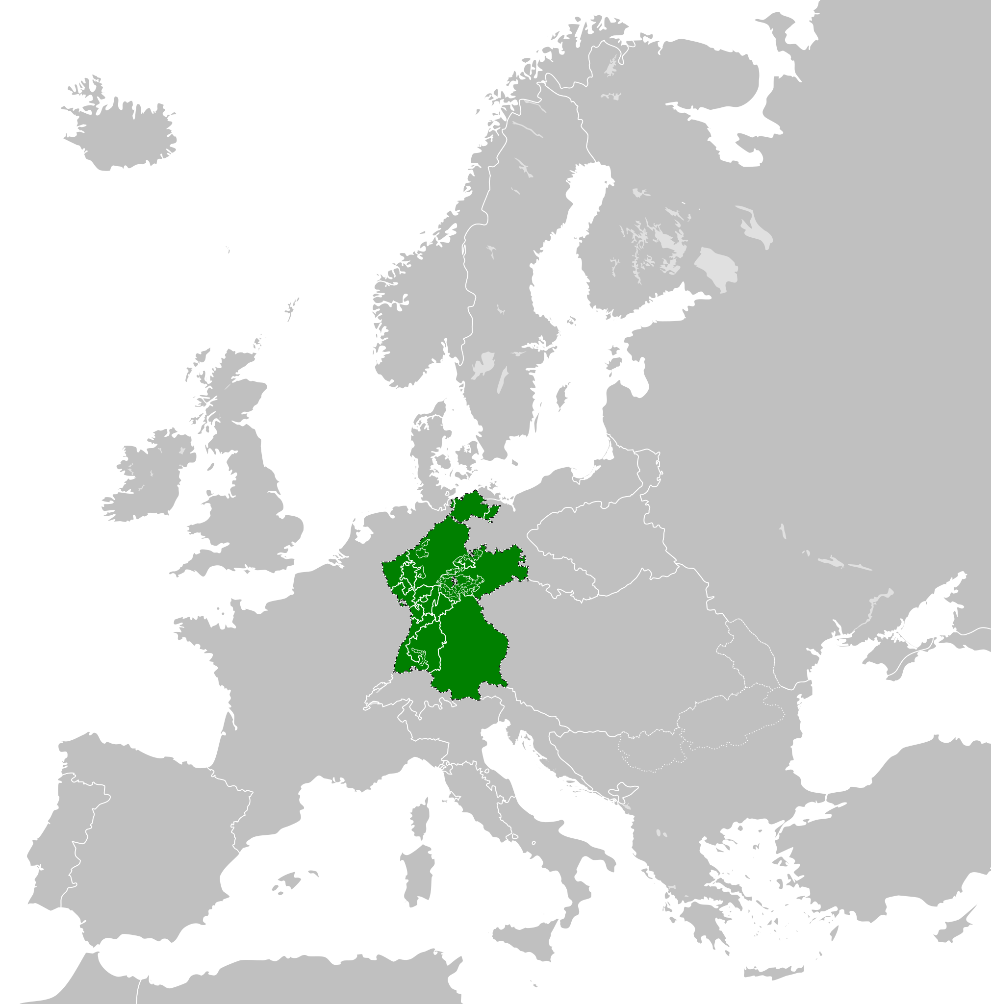
tóng-àn:Confederation of the Rhine (1812).svg

此 SVG 檔案的 PNG 預覽的大小:450 × 456 siōng-sò͘。 Kî-thaⁿ--ê kái-sek-tō͘: 237 × 240 siōng-sò͘ | 474 × 480 siōng-sò͘ | 758 × 768 siōng-sò͘ | 1,011 × 1,024 siōng-sò͘ | 2,021 × 2,048 siōng-sò͘.
Choân kái-sek-tō͘ (SVG ùng-giông, chék-cháung: 450 × 456 chuông-só, ùng-giông duâi-nâung:611 KB)
|
|
Che sī tùi Wikimedia Commons ín--lâi ê chi̍t hūn tóng-àn. I tī hia ê kì-su̍t-ia̍h téng-bīn ê chu-sìn hián-sī ùi ē-té. |
Khài-iàu


.svg)
.svg)
.svg)
.svg)
.svg)


.svg)
.svg)
.svg)


.png)
.png)


.svg)


.svg)

.svg)


.svg)
.svg)
.svg)
.svg)


.svg)
.png)


.svg)


.svg)
.svg)


.svg)


.svg)


.svg)
.svg)
.svg)
.svg)
.svg)
.svg)
.svg)
.svg)
_cropped.svg)
.svg)
.svg)
.svg)
.svg)
.svg)
.svg)
.svg)
.svg)
.svg)
.svg)
.svg)
.svg)
.svg)
.svg)
.svg)
.svg)
.svg)
.svg)
.svg)
.svg)
.svg)
.svg)
.svg)
.svg)
.svg)
.svg)
.svg)
.svg)
.svg)
.svg)
.svg)
.svg)
.svg)
.svg)
.svg)
.svg)
.svg)
.svg)
.svg)
.svg)
.svg)
.svg)
.svg)
.svg)
.svg)
Tóng-àn le̍k-sú
Chhi̍h ji̍t-kî/sî-kan, khoàⁿ hit sî-chūn--ê tóng-àn.
| Ji̍t-kî/Sî-kan | Sáuk-liŏk-dù | Chióh-cháung | Iōng-chiá | Chù-kái | |
|---|---|---|---|---|---|
| hiān-chāi | 2018-nî 1-goe̍h 5-ji̍t (pài-gō·) 14:59 | | 450 × 456(611 KB) | TRAJAN 117 | +++ |
| 2013-nî 10-goe̍h 3-ji̍t (pài-sì) 15:35 |  | 450 × 456(607 KB) | Alphathon | Added constituent states | |
| 2012-nî 7-goe̍h 30-ji̍t (pài-it) 18:34 |  | 450 × 456(464 KB) | Alphathon | Fixed some principalities | |
| 2012-nî 2-goe̍h 23-ji̍t (pài-sì) 17:07 |  | 450 × 456(444 KB) | TRAJAN 117 | {{Information |Description ={{en|1=The Confederation of the Rhine in 1812.}} |Source ={{own}} {{AttribSVG|First French Empire 1812.svg|Alphathon}} |Author =25px '''[[User:TRAJAN 117|TRAJAN 1... |
Iáⁿ-siōng liân-kiat
Bô poàⁿ ia̍h liân kàu chit tiuⁿ iáⁿ-siōng.
tóng-àn hō͘ lâng sái--ê chōng-hóng
Ē-kha--ê kî-thaⁿ wiki ēng tio̍h chit--ê tóng-àn:
- ast.wikipedia.org hō͘ lâng ēng--ê chêng-hêng
- azb.wikipedia.org hō͘ lâng ēng--ê chêng-hêng
- be.wikipedia.org hō͘ lâng ēng--ê chêng-hêng
- cs.wikipedia.org hō͘ lâng ēng--ê chêng-hêng
- da.wikipedia.org hō͘ lâng ēng--ê chêng-hêng
- de.wikipedia.org hō͘ lâng ēng--ê chêng-hêng
- el.wikipedia.org hō͘ lâng ēng--ê chêng-hêng
- en.wikipedia.org hō͘ lâng ēng--ê chêng-hêng
- es.wikipedia.org hō͘ lâng ēng--ê chêng-hêng
- eu.wikipedia.org hō͘ lâng ēng--ê chêng-hêng
- fi.wikipedia.org hō͘ lâng ēng--ê chêng-hêng
- gd.wikipedia.org hō͘ lâng ēng--ê chêng-hêng
- gl.wikipedia.org hō͘ lâng ēng--ê chêng-hêng
- he.wikipedia.org hō͘ lâng ēng--ê chêng-hêng
- hr.wikipedia.org hō͘ lâng ēng--ê chêng-hêng
- hu.wikipedia.org hō͘ lâng ēng--ê chêng-hêng
- id.wikipedia.org hō͘ lâng ēng--ê chêng-hêng
- it.wikipedia.org hō͘ lâng ēng--ê chêng-hêng
- ja.wikipedia.org hō͘ lâng ēng--ê chêng-hêng
- ko.wikipedia.org hō͘ lâng ēng--ê chêng-hêng
- lt.wikipedia.org hō͘ lâng ēng--ê chêng-hêng
- lv.wikipedia.org hō͘ lâng ēng--ê chêng-hêng
- mk.wikipedia.org hō͘ lâng ēng--ê chêng-hêng
- mn.wikipedia.org hō͘ lâng ēng--ê chêng-hêng
- ms.wikipedia.org hō͘ lâng ēng--ê chêng-hêng
- pl.wikipedia.org hō͘ lâng ēng--ê chêng-hêng
- pt.wikipedia.org hō͘ lâng ēng--ê chêng-hêng
- ru.wikipedia.org hō͘ lâng ēng--ê chêng-hêng
- sco.wikipedia.org hō͘ lâng ēng--ê chêng-hêng
- sk.wikipedia.org hō͘ lâng ēng--ê chêng-hêng
- sl.wikipedia.org hō͘ lâng ēng--ê chêng-hêng
- sv.wikipedia.org hō͘ lâng ēng--ê chêng-hêng
- th.wikipedia.org hō͘ lâng ēng--ê chêng-hêng
- tr.wikipedia.org hō͘ lâng ēng--ê chêng-hêng
- www.wikidata.org hō͘ lâng ēng--ê chêng-hêng
- zh-yue.wikipedia.org hō͘ lâng ēng--ê chêng-hêng
- zh.wikipedia.org hō͘ lâng ēng--ê chêng-hêng
.svg)