
tóng-àn:Hawaje-NoRedLine.jpg

Choân kái-sek-tō͘ (3,600 × 2,800 siōng-sò͘ , tóng-àn chiàm-liōng: 2.81 MB, MIME luī-hêng: image/jpeg)
|
|
Che sī tùi Wikimedia Commons ín--lâi ê chi̍t hūn tóng-àn. I tī hia ê kì-su̍t-ia̍h téng-bīn ê chu-sìn hián-sī ùi ē-té. |
Khài-iàu
| Soat-bêng |
Čeština: Satelitní pohled na Havajské ostrovy
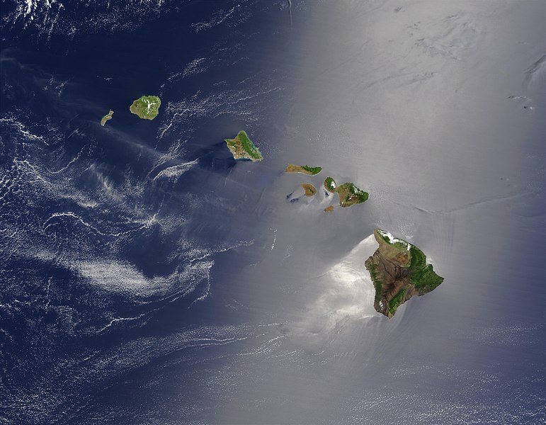
English: Satellite view of Hawaii archipelago (USA) Original description from NASA:
Français : Vue satellite de l'archipel d'Hawaï (États-Unis) |
| Ji̍t-kî | |
| Chhut-chhù |
|
| Chok-chiá | Jacques Descloitres |
| 其他版本 |
 |
| 這是一張修飾過的圖片,即本圖片是用軟體修改過後的版本,修改的方式或內容有:cloned out and healed little red line on the big island。原版圖片來源:Hawaje.jpg。修改者:IdLoveOne。
|
Siū-khoân
| 本作品由NASA創作,屬於公有領域。根據NASA的版權政策:“NASA的創作除非另有聲明否則不受版權保護。”(參見:Template:PD-USGov/zh,NASA版權政策或JPL圖像使用政策) | ||
 |
警告:
|
原始上傳日誌
本檔案衍生自: Hawaje.jpg
- File:Hawaje.jpg licensed with PD-USGov-NASA
- 2005-10-26T18:19:43Z Palladinus 3600x2800 (1211908 Bytes) Hawaii Islands
Uploaded with derivativeFX
評價
|
本图像被选为2011年6月16日的今日图片。其说明如下: 其他语言:
Čeština: Satelitní pohled na Havajské ostrovy Eesti: Hawaii saared satelliidifotol. Magyar: Hawaii szigetvilágának műholdas képe Português: Texto de cabeçalho. Русский: Спутниковая фотография Гавайских островов 한국어: 하와이 제도의 위성 사진. 日本語: ハワイ諸島の衛星写真 中文: 美国夏威夷的卫星照片 |
Tóng-àn le̍k-sú
Chhi̍h ji̍t-kî/sî-kan, khoàⁿ hit sî-chūn--ê tóng-àn.
| Ji̍t-kî/Sî-kan | Sáuk-liŏk-dù | Chióh-cháung | Iōng-chiá | Chù-kái | |
|---|---|---|---|---|---|
| hiān-chāi | 2010-nî 9-goe̍h 1-ji̍t (pài-saⁿ) 22:24 | | 3,600 × 2,800(2.81 MB) | IdLoveOne~commonswiki | {{RetouchedPicture|cloned out and healed little red line on the big island|editor=IdLoveOne|orig=Hawaje.jpg}} {{self|PD-USGov-NASA}} == {{Original upload log}} == This image is a derivative work of the following images: *File:Hawaje.jpg licensed w |
Iáⁿ-siōng liân-kiat
Í-hā ê ia̍h liân kàu chit ê iáⁿ-siōng:
tóng-àn hō͘ lâng sái--ê chōng-hóng
Ē-kha--ê kî-thaⁿ wiki ēng tio̍h chit--ê tóng-àn:
- ace.wikipedia.org hō͘ lâng ēng--ê chêng-hêng
- af.wikipedia.org hō͘ lâng ēng--ê chêng-hêng
- als.wikipedia.org hō͘ lâng ēng--ê chêng-hêng
- ar.wikipedia.org hō͘ lâng ēng--ê chêng-hêng
- ary.wikipedia.org hō͘ lâng ēng--ê chêng-hêng
- arz.wikipedia.org hō͘ lâng ēng--ê chêng-hêng
- ast.wikipedia.org hō͘ lâng ēng--ê chêng-hêng
- azb.wikipedia.org hō͘ lâng ēng--ê chêng-hêng
- az.wikipedia.org hō͘ lâng ēng--ê chêng-hêng
- ba.wikipedia.org hō͘ lâng ēng--ê chêng-hêng
- be-tarask.wikipedia.org hō͘ lâng ēng--ê chêng-hêng
- bh.wikipedia.org hō͘ lâng ēng--ê chêng-hêng
- bn.wikipedia.org hō͘ lâng ēng--ê chêng-hêng
- bn.wikibooks.org hō͘ lâng ēng--ê chêng-hêng
- ca.wikipedia.org hō͘ lâng ēng--ê chêng-hêng
- ceb.wikipedia.org hō͘ lâng ēng--ê chêng-hêng
- crh.wikipedia.org hō͘ lâng ēng--ê chêng-hêng
- cs.wikipedia.org hō͘ lâng ēng--ê chêng-hêng
- cv.wikipedia.org hō͘ lâng ēng--ê chêng-hêng
- cy.wikipedia.org hō͘ lâng ēng--ê chêng-hêng
- dag.wikipedia.org hō͘ lâng ēng--ê chêng-hêng
- de.wikipedia.org hō͘ lâng ēng--ê chêng-hêng
- diq.wikipedia.org hō͘ lâng ēng--ê chêng-hêng
- el.wikipedia.org hō͘ lâng ēng--ê chêng-hêng
- en.wikipedia.org hō͘ lâng ēng--ê chêng-hêng
檢視此檔案的更多全域使用狀況。