
tóng-àn:Map Dutch World scris.png
Seng khoàⁿ chiàm-liōng: 800 × 351 siōng-sò͘. Kî-thaⁿ--ê kái-sek-tō͘: 320 × 140 siōng-sò͘ | 640 × 281 siōng-sò͘ | 1,425 × 625 siōng-sò͘.
Choân kái-sek-tō͘ (1,425 × 625 siōng-sò͘ , tóng-àn chiàm-liōng: 61 KB, MIME luī-hêng: image/png)
|
|
Che sī tùi Wikimedia Commons ín--lâi ê chi̍t hūn tóng-àn. I tī hia ê kì-su̍t-ia̍h téng-bīn ê chu-sìn hián-sī ùi ē-té. |
Khài-iàu
New map for Dutch-speaking world with country names. Modified version of Image:Map Dutch World nou.png
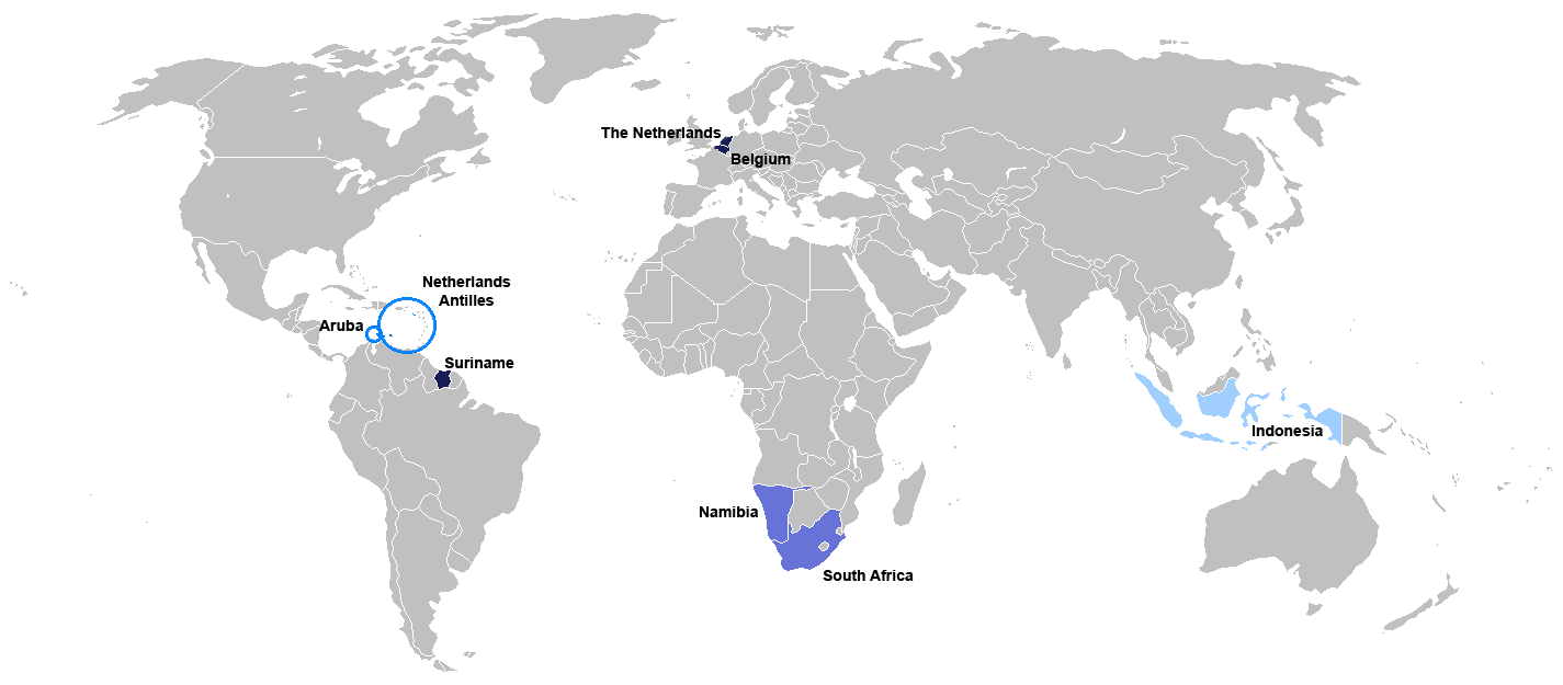
Deutsch: Legende:
- Dunkelblau: Mutter- und Mehrheitssprache
- Blau: Afrikaans (Tochtersprache)
- Hellblau: Zweit- oder nicht offizielle Sprache bzw. weiterhin vorhandene Kenntnis
English: English: Legend:
- Dark blue: native and majority language
- Blue: Afrikaans (daughter language)
- Light blue: secondary (non-official language), where some knowledge persists
Français : Français : Légende:
- Bleu foncé : langue maternelle et majoritaire
- Bleu : Afrikaans («langue fille»)
- Bleu clair : langue secondaire ou non officielle
Italiano: Italiano: Legenda:
- Blu scuro: lingua madre e maggioritaria
- Blu: Afrikaans (lingua affiliata)
- Blu chiaro: seconda lingua e/o non ufficiale, dove la sua conoscenza persiste sino ad oggi
Nederlands: Nederlands: Legenda:
- Donkerblauw: Moedertaal en belangrijkste taal
- Blauw: Afrikaans (dochtertaal)
- Lichtblauw: secundaire taal (niet-officiële taal), waar enkele kennis bestaat
Português: Português: Legenda:
- Azul escuro: língua mãe e majoritária
- Azul: Africâner (língua descendente)
- Azul claro: língua secundária (não oficial), onde ainda persiste algum conhecimento
Română: Română: Legendă:
- Albastru închis: limbă naţională
- Albastru: Afrikaans
- Albastru deschis: limbă secundară, neoficială
Español: Español : Leyenda:
- Azul obscuro : lengua materna y mayoritaria
- Azul : Afrikaans (lengua «hija»)
- Azul claro : lengua secundaria (no oficial), donde aún persiste conocimiento de ella.

|
這個檔案已經被Map of the Dutch World.svg取代。 建議您使用其他圖像。請注意要刪除被取代的圖像的話,您需要首先取得社群共識。
|

|
File:Map of the Dutch World.svg是本檔案的向量版本。 請優先使用那個圖片而非本點陣圖片。
File:Map Dutch World scris.png → File:Map of the Dutch World.svg
更多資訊請參閱Help:SVG/zh。 |
 |
Siū-khoân
我,本作品的著作權持有者,決定用以下授權條款發佈本作品:

|
已授權您依據自由軟體基金會發行的無固定段落、封面文字和封底文字GNU自由文件授權條款1.2版或任意後續版本,對本檔進行複製、傳播和/或修改。該協議的副本列在GNU自由文件授權條款中。 |
| 此檔案採用創用CC 姓名標示-相同方式分享 3.0 未在地化版本授權條款。 | ||
| ||
| 已新增授權條款標題至此檔案,作為GFDL授權更新的一部份。 |
Tóng-àn le̍k-sú
Chhi̍h ji̍t-kî/sî-kan, khoàⁿ hit sî-chūn--ê tóng-àn.
| Ji̍t-kî/Sî-kan | Sáuk-liŏk-dù | Chióh-cháung | Iōng-chiá | Chù-kái | |
|---|---|---|---|---|---|
| hiān-chāi | 2010-nî 7-goe̍h 7-ji̍t (pài-saⁿ) 19:06 | | 1,425 × 625(61 KB) | Hooiwind | deeper colours so it is easier to see the countries on a smaller scale + removal of "minority dots", geographically confusing and pretty arbitrary. |
| 2007-nî 2-goe̍h 16-ji̍t (pài-gō·) 17:46 |  | 1,425 × 625(34 KB) | Danutz | New map for Dutch-speaking world with country names. Modified version of Image:Map Dutch World nou.png English: Legend: *Dark blue: native language *Blue: administrative language *Light blue: secondary, non-official language *Green square: minori |
Iáⁿ-siōng liân-kiat
Bô poàⁿ ia̍h liân kàu chit tiuⁿ iáⁿ-siōng.
tóng-àn hō͘ lâng sái--ê chōng-hóng
Ē-kha--ê kî-thaⁿ wiki ēng tio̍h chit--ê tóng-àn:
- jv.wikipedia.org hō͘ lâng ēng--ê chêng-hêng
- nl.wikibooks.org hō͘ lâng ēng--ê chêng-hêng
- sat.wikipedia.org hō͘ lâng ēng--ê chêng-hêng