
tóng-àn:Rajendra map new.svg

Choân kái-sek-tō͘ (SVG ùng-giông, chék-cháung: 466 × 333 chuông-só, ùng-giông duâi-nâung:220 KB)
|
|
Che sī tùi Wikimedia Commons ín--lâi ê chi̍t hūn tóng-àn. I tī hia ê kì-su̍t-ia̍h téng-bīn ê chu-sìn hián-sī ùi ē-té. |
Khài-iàu
| Soat-bêng |
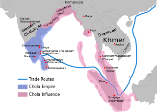
per http://cw.routledge.com/textbooks/9780415485432/15.asp "THE CŌḶAS" by K. A. Nilakanta Sastri and other histories of South Asia consulted.
The file has several changes from the original. The map is corrected to show are of influence and direct control in Sri Lanka. Correction was based on the work of Spencer, G. (1976). The Politics of Plunder: The Cholas in Eleventh-Century Ceylon. The Journal of Asian Studies, 35(3), 405-419. doi:10.2307/2053272. The correction about the Chola influence in Malay areas is based on https://archive.org/details/earlykingdomsofi0000muno/page/118/mode/2up The influence added the area of Lamuri based on Tanjore inscription. Andaman is deleted leaving only Nicobar (information on Tanjore inscription). |
| Ji̍t-kî | (UTC) |
| Chhut-chhù | |
| Chok-chiá |
|
| 這是一張修飾過的圖片,即本圖片是用軟體修改過後的版本,修改的方式或內容有:Redrew png as svg。原版圖片來源:Rajendra map new.png。修改者:Gregors。
|
| 此檔案採用創用CC 姓名標示-相同方式分享 3.0 未在地化版本授權條款。 受免責聲明的約束。 | ||
| ||
| 已新增授權條款標題至此檔案,作為GFDL授權更新的一部份。 |

|
已授權您依據自由軟體基金會發行的無固定段落、封面文字和封底文字GNU自由文件授權條款1.2版或任意後續版本,對本檔進行複製、傳播和/或修改。該協議的副本列在GNU自由文件授權條款中。 |
原始上傳日誌
This image is a derivative work of the following images:
- File:Rajendra_map_new.png licensed with Cc-by-sa-3.0-migrated-with-disclaimers, GFDL-en, GFDL-user-en-with-disclaimers
- 2011-03-21T12:16:23Z Gregors 600x429 (102117 Bytes) Bitmap of svg that i will soon upload. ~~~~
- 2009-06-07T09:04:06Z Maukie 629x442 (215021 Bytes) {{Information |Description={{en|Map showing the extent of the [[:en:Chola empire|]] during [[:en:Rajendra Chola I|]] (c. 1030 CE)}} |Source=Transferred from [http://en.wikipedia.org en.wikipedia]; transfer was stated to be ma
Uploaded with derivativeFX
Tóng-àn le̍k-sú
Chhi̍h ji̍t-kî/sî-kan, khoàⁿ hit sî-chūn--ê tóng-àn.
| Ji̍t-kî/Sî-kan | Sáuk-liŏk-dù | Chióh-cháung | Iōng-chiá | Chù-kái | |
|---|---|---|---|---|---|
| hiān-chāi | 2023-nî 12-goe̍h 21-ji̍t (pài-sì) 21:50 | | 466 × 333(220 KB) | SKAG123 | Reverted to version as of 05:56, 29 November 2023 (UTC) |
| 2023-nî 12-goe̍h 17-ji̍t (lé-pài) 13:15 |  | 466 × 333(189 KB) | Ranithraj | Reverted to version as of 05:07, 25 November 2023 (UTC) | |
| 2023-nî 11-goe̍h 29-ji̍t (pài-saⁿ) 05:56 |  | 466 × 333(220 KB) | Surijeal | Reverted to version as of 01:27, 25 November 2023 (UTC) Nonsense or unsubstantiated question, it does not give reasoning for revert | |
| 2023-nî 11-goe̍h 25-ji̍t (pài-la̍k) 05:07 |  | 466 × 333(189 KB) | Indo12122 | Reverted to version as of 06:39, 27 June 2022 (UTC) It just includes territories which were influenced by Sri vijaya. What about the other kingdoms and principalities? | |
| 2023-nî 11-goe̍h 25-ji̍t (pài-la̍k) 01:27 |  | 466 × 333(220 KB) | SKAG123 | Reverted to version as of 11:33, 29 November 2022 (UTC) last sourced map | |
| 2023-nî 11-goe̍h 23-ji̍t (pài-sì) 09:47 |  | 466 × 333(189 KB) | Indo12122 | Reverted to version as of 06:39, 27 June 2022 (UTC) | |
| 2022-nî 12-goe̍h 27-ji̍t (pài-jī) 15:28 |  | 466 × 333(218 KB) | Surijeal | Deleted areas on coastal Myanmar, enlarge Rohana text | |
| 2022-nî 11-goe̍h 29-ji̍t (pài-jī) 11:33 |  | 466 × 333(220 KB) | Surijeal | Rohana, changed location of Vengi, deleted Andaman (only Nicobar), added Lamuri | |
| 2022-nî 11-goe̍h 28-ji̍t (pài-it) 06:48 |  | 466 × 333(210 KB) | Surijeal | Changed Srivijaya's territory based on https://archive.org/details/earlykingdomsofi0000muno/page/118/mode/2up | |
| 2022-nî 11-goe̍h 19-ji̍t (pài-la̍k) 09:55 |  | 512 × 394(78 KB) | Lipwe | {{Information |Description= |Source= |Date= |Author= |Permission= |other_versions= }} |
Iáⁿ-siōng liân-kiat
Í-hā ê ia̍h liân kàu chit ê iáⁿ-siōng:
tóng-àn hō͘ lâng sái--ê chōng-hóng
Ē-kha--ê kî-thaⁿ wiki ēng tio̍h chit--ê tóng-àn:
- ar.wikipedia.org hō͘ lâng ēng--ê chêng-hêng
- azb.wikipedia.org hō͘ lâng ēng--ê chêng-hêng
- ba.wikipedia.org hō͘ lâng ēng--ê chêng-hêng
- be.wikipedia.org hō͘ lâng ēng--ê chêng-hêng
- bn.wikipedia.org hō͘ lâng ēng--ê chêng-hêng
- ca.wikipedia.org hō͘ lâng ēng--ê chêng-hêng
- cs.wikipedia.org hō͘ lâng ēng--ê chêng-hêng
- el.wikipedia.org hō͘ lâng ēng--ê chêng-hêng
- en.wikipedia.org hō͘ lâng ēng--ê chêng-hêng
- History of India
- Tamil Nadu
- Middle kingdoms of India
- South India
- History of South India
- China–India relations
- History of the Indian Navy
- Rajendra I
- Rajadhiraja I
- Indian maritime history
- Chola Empire
- History of Tamil Nadu
- User talk:Venu62
- Golden Age of India
- Talk:List of Sri Lankan monarchs
- List of Solesvara temples
- Ancient maritime history
- Chola Navy
- South Asia
- Portal:Tamils/Selected article
- Portal:Tamils/Selected article/3
- Talk:Chola conquest of Anuradhapura
- History of Indian influence on Southeast Asia
- Relationship of the Tamils with the Chinese
- Relationship of the Cholas with the Chinese
- Coastline of Tamil Nadu
- Names of Bengal
- User:Gauravkumar4291/Notes/GS/Cul/Chola Empire
- User:Կիմա34/sandbox
- eo.wikipedia.org hō͘ lâng ēng--ê chêng-hêng
- es.wikipedia.org hō͘ lâng ēng--ê chêng-hêng
- fa.wikipedia.org hō͘ lâng ēng--ê chêng-hêng
檢視此檔案的更多全域使用狀況。