
tóng-àn:Santa lucia castries political.png

Seng khoàⁿ chiàm-liōng: 424 × 599 siōng-sò͘. Kî-thaⁿ--ê kái-sek-tō͘: 170 × 240 siōng-sò͘ | 339 × 480 siōng-sò͘ | 733 × 1,036 siōng-sò͘.
Choân kái-sek-tō͘ (733 × 1,036 siōng-sò͘ , tóng-àn chiàm-liōng: 20 KB, MIME luī-hêng: image/png)
|
|
Che sī tùi Wikimedia Commons ín--lâi ê chi̍t hūn tóng-àn. I tī hia ê kì-su̍t-ia̍h téng-bīn ê chu-sìn hián-sī ùi ē-té. |
Khài-iàu
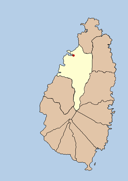
| Soat-bêng | this is a political map showing the quarter of Castries on the island nation of Santa Lucia. I created it myself by using the GIMP to trace a public domain map that i found at the Perry-Castañeda Library Map Collection. |
| Ji̍t-kî | 2005年9-goe̍h21日 (原始上傳日期) |
| Chhut-chhù | No machine-readable source provided. Own work assumed (based on copyright claims). |
| Chok-chiá | No machine-readable author provided. Doviende~commonswiki assumed (based on copyright claims). |
Siū-khoân
| 我,此作品的版權所有人,釋出此作品至公共領域。此授權條款在全世界均適用。 這可能在某些國家不合法,如果是的話: 我授予任何人有權利使用此作品於任何用途,除受法律約束外,不受任何限制。 |

|
File:Saint Lucia district of Castries.svg是本檔案的向量版本。 如果品質不低,就應該優先使用該檔案,而非PNG檔案。
File:Santa lucia castries political.png → File:Saint Lucia district of Castries.svg
更多資訊請參閱Help:SVG/zh。 |
 |
Tóng-àn le̍k-sú
Chhi̍h ji̍t-kî/sî-kan, khoàⁿ hit sî-chūn--ê tóng-àn.
| Ji̍t-kî/Sî-kan | Sáuk-liŏk-dù | Chióh-cháung | Iōng-chiá | Chù-kái | |
|---|---|---|---|---|---|
| hiān-chāi | 2005-nî 9-goe̍h 21-ji̍t (pài-saⁿ) 03:43 | | 733 × 1,036(20 KB) | Doviende~commonswiki | this is a political map showing the quarter of Castries on the island nation of Santa Lucia. I created it myself by using the GIMP to trace [http://www.lib.utexas.edu/maps/americas/saint_lucia.gif a public domain map that i found] at the Perry-Casta� |
Iáⁿ-siōng liân-kiat
Í-hā ê ia̍h liân kàu chit ê iáⁿ-siōng:
tóng-àn hō͘ lâng sái--ê chōng-hóng
Ē-kha--ê kî-thaⁿ wiki ēng tio̍h chit--ê tóng-àn:
- af.wikipedia.org hō͘ lâng ēng--ê chêng-hêng
- am.wikipedia.org hō͘ lâng ēng--ê chêng-hêng
- ban.wikipedia.org hō͘ lâng ēng--ê chêng-hêng
- cy.wikipedia.org hō͘ lâng ēng--ê chêng-hêng
- en.wikipedia.org hō͘ lâng ēng--ê chêng-hêng
- fa.wikipedia.org hō͘ lâng ēng--ê chêng-hêng
- fi.wikipedia.org hō͘ lâng ēng--ê chêng-hêng
- hr.wikipedia.org hō͘ lâng ēng--ê chêng-hêng
- hu.wikipedia.org hō͘ lâng ēng--ê chêng-hêng
- id.wikipedia.org hō͘ lâng ēng--ê chêng-hêng
- incubator.wikimedia.org hō͘ lâng ēng--ê chêng-hêng
- ja.wikipedia.org hō͘ lâng ēng--ê chêng-hêng
- ko.wikipedia.org hō͘ lâng ēng--ê chêng-hêng
- mk.wikipedia.org hō͘ lâng ēng--ê chêng-hêng
- ml.wikipedia.org hō͘ lâng ēng--ê chêng-hêng
- mr.wikipedia.org hō͘ lâng ēng--ê chêng-hêng
- nl.wikipedia.org hō͘ lâng ēng--ê chêng-hêng
- nn.wikipedia.org hō͘ lâng ēng--ê chêng-hêng
- ps.wikipedia.org hō͘ lâng ēng--ê chêng-hêng
- sah.wikipedia.org hō͘ lâng ēng--ê chêng-hêng
- sh.wikipedia.org hō͘ lâng ēng--ê chêng-hêng
- sv.wikipedia.org hō͘ lâng ēng--ê chêng-hêng
- ta.wikipedia.org hō͘ lâng ēng--ê chêng-hêng
- th.wikipedia.org hō͘ lâng ēng--ê chêng-hêng
- tr.wikipedia.org hō͘ lâng ēng--ê chêng-hêng
- ur.wikipedia.org hō͘ lâng ēng--ê chêng-hêng
- vi.wikipedia.org hō͘ lâng ēng--ê chêng-hêng
- yo.wikipedia.org hō͘ lâng ēng--ê chêng-hêng