
tóng-àn:Pyrenees Mountains view from satellite.jpg

Seng khoàⁿ chiàm-liōng: 780 × 600 siōng-sò͘. Kî-thaⁿ--ê kái-sek-tō͘: 312 × 240 siōng-sò͘ | 624 × 480 siōng-sò͘ | 999 × 768 siōng-sò͘ | 1,280 × 985 siōng-sò͘ | 2,600 × 2,000 siōng-sò͘.
Choân kái-sek-tō͘ (2,600 × 2,000 siōng-sò͘ , tóng-àn chiàm-liōng: 877 KB, MIME luī-hêng: image/jpeg)
|
|
Che sī tùi Wikimedia Commons ín--lâi ê chi̍t hūn tóng-àn. I tī hia ê kì-su̍t-ia̍h téng-bīn ê chu-sìn hián-sī ùi ē-té. |
Khài-iàu
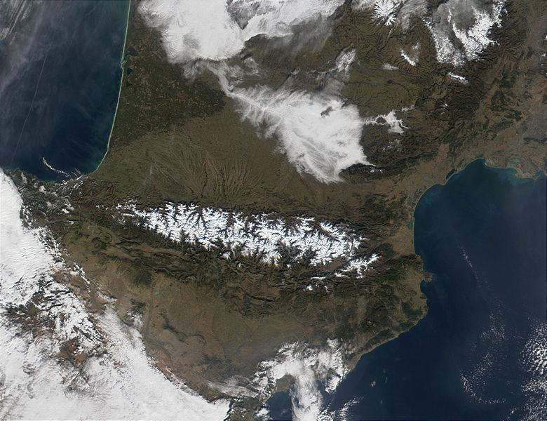
| Soat-bêng | The Pyrenees Mountains (center) act as a natural border between France to the north and Spain to the south. In this MODIS image from January 18, 2002, they are covered in snow (bright red in the false-color image.) At upper left, contrails are visible over the Bay of Biscay, which, along the French shores, sport miles and miles of white sandy beaches. |
| Ji̍t-kî | |
| Chhut-chhù | http://visibleearth.nasa.gov/view_rec.php?id=2690 |
| Chok-chiá | Jacques Descloitres, MODIS Land Rapid Response Team, NASA/GSFC |
Siū-khoân
| 本作品由NASA創作,屬於公有領域。根據NASA的版權政策:“NASA的創作除非另有聲明否則不受版權保護。”(參見:Template:PD-USGov/zh,NASA版權政策或JPL圖像使用政策) | ||
 |
警告:
|
Tóng-àn le̍k-sú
Chhi̍h ji̍t-kî/sî-kan, khoàⁿ hit sî-chūn--ê tóng-àn.
| Ji̍t-kî/Sî-kan | Sáuk-liŏk-dù | Chióh-cháung | Iōng-chiá | Chù-kái | |
|---|---|---|---|---|---|
| hiān-chāi | 2004-nî 12-goe̍h 3-ji̍t (pài-gō·) 20:30 | | 2,600 × 2,000(877 KB) | Alfio | pyrenees mountains seen from satellite |
Iáⁿ-siōng liân-kiat
Í-hā ê ia̍h liân kàu chit ê iáⁿ-siōng:
tóng-àn hō͘ lâng sái--ê chōng-hóng
Ē-kha--ê kî-thaⁿ wiki ēng tio̍h chit--ê tóng-àn:
- an.wikipedia.org hō͘ lâng ēng--ê chêng-hêng
- ast.wikipedia.org hō͘ lâng ēng--ê chêng-hêng
- ca.wikipedia.org hō͘ lâng ēng--ê chêng-hêng
- cs.wikipedia.org hō͘ lâng ēng--ê chêng-hêng
- es.wikipedia.org hō͘ lâng ēng--ê chêng-hêng
- eu.wikipedia.org hō͘ lâng ēng--ê chêng-hêng
- ext.wikipedia.org hō͘ lâng ēng--ê chêng-hêng
- fi.wikipedia.org hō͘ lâng ēng--ê chêng-hêng
- gl.wikipedia.org hō͘ lâng ēng--ê chêng-hêng
- he.wikipedia.org hō͘ lâng ēng--ê chêng-hêng
- it.wikipedia.org hō͘ lâng ēng--ê chêng-hêng
- ja.wikipedia.org hō͘ lâng ēng--ê chêng-hêng
- kk.wikipedia.org hō͘ lâng ēng--ê chêng-hêng
- la.wiktionary.org hō͘ lâng ēng--ê chêng-hêng
- lfn.wikipedia.org hō͘ lâng ēng--ê chêng-hêng
- nl.wikipedia.org hō͘ lâng ēng--ê chêng-hêng
- oc.wikipedia.org hō͘ lâng ēng--ê chêng-hêng
- oc.wiktionary.org hō͘ lâng ēng--ê chêng-hêng
- pl.wiktionary.org hō͘ lâng ēng--ê chêng-hêng
- pms.wikipedia.org hō͘ lâng ēng--ê chêng-hêng
- pt.wikipedia.org hō͘ lâng ēng--ê chêng-hêng
- qu.wikipedia.org hō͘ lâng ēng--ê chêng-hêng
- war.wikipedia.org hō͘ lâng ēng--ê chêng-hêng