
tóng-àn:Location Ryukyu Islands.PNG

Seng khoàⁿ chiàm-liōng: 550 × 599 siōng-sò͘. Kî-thaⁿ--ê kái-sek-tō͘: 220 × 240 siōng-sò͘ | 441 × 480 siōng-sò͘ | 906 × 987 siōng-sò͘.
Choân kái-sek-tō͘ (906 × 987 siōng-sò͘ , tóng-àn chiàm-liōng: 151 KB, MIME luī-hêng: image/png)
|
|
Che sī tùi Wikimedia Commons ín--lâi ê chi̍t hūn tóng-àn. I tī hia ê kì-su̍t-ia̍h téng-bīn ê chu-sìn hián-sī ùi ē-té. |
Khài-iàu
| Soat-bêng |
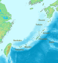
English: Location map of the Ryukyu islands (Nansei islands). According to the standardized geographical names of Japan, the Nansei Islands (南西諸島, Nansei Shotō, lit. "Southwest Islands") cover the entire island chain: the Ōsumi, Tokara, Amami, Okinawa, Sakishima Islands (further divided into the Miyako and Yaeyama Islands), the Senkaku Islands, and the Daitō Islands, with Yonaguni the westernmost. |
| Ji̍t-kî | 2006, 2022 |
| Chhut-chhù | Ka-tī chò--ê |
| Chok-chiá | Nanshu, Michiel1972 |
| 其他版本 | alternative version: File:Location of the Ryukyu Islands.JPG |
Siū-khoân
This image is in the public domain because it came from the site https://www.demis.nl/products/web-map-server/examples/ and was released by the copyright holder. Permission is granted to copy, distribute and/or modify this map since it is based on free of copyright images from: www.demis.nl. See also approval email on de.wp and its clarification.
|
| This work has been released into the public domain by its copyright holder, www.demis.nl. This applies worldwide. 這可能在某些國家不合法,如果是的話: www.demis.nl授予任何人有權利使用此作品於任何用途,除受法律約束外,不受任何限制。
|
Tóng-àn le̍k-sú
Chhi̍h ji̍t-kî/sî-kan, khoàⁿ hit sî-chūn--ê tóng-àn.
| Ji̍t-kî/Sî-kan | 細張圖 | 寸尺 | Iōng-chiá | Chù-kái | |
|---|---|---|---|---|---|
| hiān-chāi | 2022-nî 5-goe̍h 21-ji̍t (pài-la̍k) 07:53 | | 906 × 987(151 KB) | A1Cafel | Reverted to version as of 08:43, 3 April 2022 (UTC) |
| 2022-nî 5-goe̍h 13-ji̍t (pài-gō·) 07:26 |  | 2,309 × 1,594(527 KB) | Sturmgewehr88 | Higher resolution map | |
| 2022-nî 4-goe̍h 3-ji̍t (lé-pài) 08:43 |  | 906 × 987(151 KB) | Nanshu | Adjust locations. Larger labels. | |
| 2006-nî 1-goe̍h 19-ji̍t (pài-sì) 22:45 |  | 482 × 377(85 KB) | Michiel1972 | *Location_Ryukyu_Islands {{demis}} |
Iáⁿ-siōng liân-kiat
Í-hā ê ia̍h liân kàu chit ê iáⁿ-siōng:
tóng-àn hō͘ lâng sái--ê chōng-hóng
Ē-kha--ê kî-thaⁿ wiki ēng tio̍h chit--ê tóng-àn:
- ar.wikipedia.org hō͘ lâng ēng--ê chêng-hêng
- en.wikipedia.org hō͘ lâng ēng--ê chêng-hêng
- fr.wikipedia.org hō͘ lâng ēng--ê chêng-hêng
- hak.wikipedia.org hō͘ lâng ēng--ê chêng-hêng
- ro.wikipedia.org hō͘ lâng ēng--ê chêng-hêng
- sn.wikipedia.org hō͘ lâng ēng--ê chêng-hêng
- uk.wikipedia.org hō͘ lâng ēng--ê chêng-hêng
- zh-yue.wikipedia.org hō͘ lâng ēng--ê chêng-hêng
- zh.wikipedia.org hō͘ lâng ēng--ê chêng-hêng