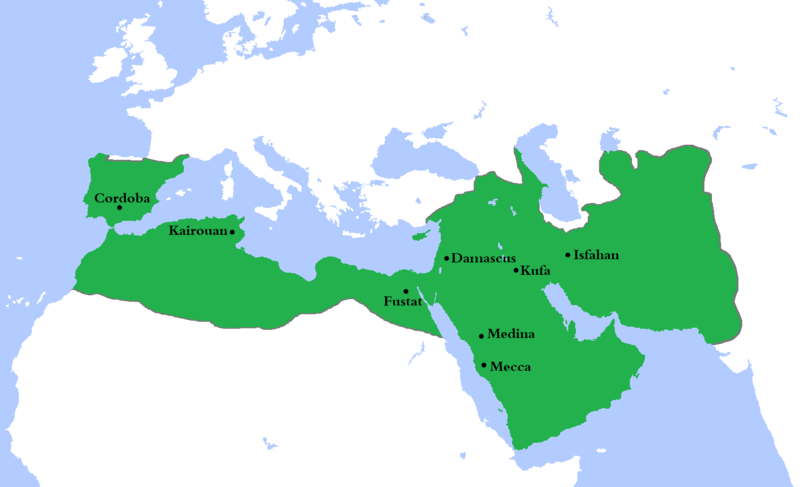
tóng-àn:Umayyad750ADloc.png

Seng khoàⁿ chiàm-liōng: 800 × 487 siōng-sò͘. Kî-thaⁿ--ê kái-sek-tō͘: 320 × 195 siōng-sò͘ | 640 × 390 siōng-sò͘ | 1,024 × 624 siōng-sò͘ | 1,481 × 902 siōng-sò͘.
Choân kái-sek-tō͘ (1,481 × 902 siōng-sò͘ , tóng-àn chiàm-liōng: 44 KB, MIME luī-hêng: image/png)
Tóng-àn le̍k-sú
Chhi̍h ji̍t-kî/sî-kan, khoàⁿ hit sî-chūn--ê tóng-àn.
| Ji̍t-kî/Sî-kan | 細張圖 | 寸尺 | Iōng-chiá | Chù-kái | |
|---|---|---|---|---|---|
| hiān-chāi | 2020-nî 8-goe̍h 4-ji̍t (pài-jī) 22:23 |  | 1,481 × 902(44 KB) | Ozan33Ankara | Corrected borders based on: The expansion of the Muslim Caliphate until 750, from William R. Shepherd's Historical Atlas. |
| 2013-nî 4-goe̍h 11-ji̍t (pài-sì) 15:24 |  | 1,481 × 902(30 KB) | HistoryofIran | {{subst:Upload marker added by en.wp UW}} {{Information |Description = {{en|Made the map more presice, the Umayyads never controlled Tabaristan because of the Dabuyid dynasty, but the Abbasids did that later.}} |Source = http://en.wikipedia.org/wiki/Fi... | |
| 2013-nî 4-goe̍h 10-ji̍t (pài-saⁿ) 15:55 |  | 1,481 × 902(37 KB) | Khateeb88 | Added the major cities of the Umayyad Caliphate: Damascus, Kufa, Isfahan, Mecca, Medina, Fustat, Kairouan, and Cordoba. | |
| 2013-nî 4-goe̍h 10-ji̍t (pài-saⁿ) 15:54 |  | 1,481 × 902(37 KB) | Khateeb88 | Added the major cities of the Umayyad Caliphate: Damascus, Kufa, Isfahan, Mecca, Medina, Fustat, Kairouan, and Cordoba. | |
| 2009-nî 4-goe̍h 22-ji̍t (pài-saⁿ) 16:17 |  | 1,481 × 902(50 KB) | Gabagool | some corrections.. | |
| 2009-nî 4-goe̍h 20-ji̍t (pài-it) 16:10 |  | 1,481 × 902(50 KB) | Gabagool | {{Information |Description={{en|1=Locator map for the Umayyad Caliphate at its greatest extent, c. AD 750. (Partially based on ''Atlas of World History'' (2007) - World 500-750, map.)}} |Source=Own work by uploader |Author=Gabagool / Ja |
Iáⁿ-siōng liân-kiat
Í-hā ê ia̍h liân kàu chit ê iáⁿ-siōng:
tóng-àn hō͘ lâng sái--ê chōng-hóng
Ē-kha--ê kî-thaⁿ wiki ēng tio̍h chit--ê tóng-àn:
- af.wikipedia.org hō͘ lâng ēng--ê chêng-hêng
- als.wikipedia.org hō͘ lâng ēng--ê chêng-hêng
- an.wikipedia.org hō͘ lâng ēng--ê chêng-hêng
- ast.wikipedia.org hō͘ lâng ēng--ê chêng-hêng
- av.wikipedia.org hō͘ lâng ēng--ê chêng-hêng
- az.wikipedia.org hō͘ lâng ēng--ê chêng-hêng
- ba.wikipedia.org hō͘ lâng ēng--ê chêng-hêng
- be.wikipedia.org hō͘ lâng ēng--ê chêng-hêng
- bg.wikipedia.org hō͘ lâng ēng--ê chêng-hêng
- bn.wikipedia.org hō͘ lâng ēng--ê chêng-hêng
- br.wikipedia.org hō͘ lâng ēng--ê chêng-hêng
- bs.wikipedia.org hō͘ lâng ēng--ê chêng-hêng
- ca.wikipedia.org hō͘ lâng ēng--ê chêng-hêng
- ckb.wikipedia.org hō͘ lâng ēng--ê chêng-hêng
- cy.wikipedia.org hō͘ lâng ēng--ê chêng-hêng
- da.wikipedia.org hō͘ lâng ēng--ê chêng-hêng
- de.wikipedia.org hō͘ lâng ēng--ê chêng-hêng
- el.wikipedia.org hō͘ lâng ēng--ê chêng-hêng
- en.wikipedia.org hō͘ lâng ēng--ê chêng-hêng
檢視此檔案的更多全域使用狀況。


