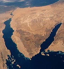
Sinai Poàn-tó
Guā-māu
(Tùi Se-nái Poàⁿ-tó choán--lâi)
 Sinai Poàn-tó ê oē-chheⁿ-tô͘ | |
| Area | 60,000 km 2(23,000 sq mi) |
|---|---|
| Population | 600,000[1] |
| Countries | Egypt |

Sinai Poàn-tó (A-la-pek-gí: شبه جزيرة سيناء; Shibh Jazirat Sina) ia̍h-sī hoan-e̍k chò Se-nái Poàn-tó, sī 1-ê saⁿ-kak-hêng ê poàn-tó, tī Tē-tiong-hái (pak) kap Âng-hái (lâm) tiong-kan, oá Aqaba-oan (tang) kap Suez-oan (sai), sio̍k-î Ai-ki̍p ê A-chiu pō͘-hūn. Lio̍k-tē piⁿ-kài: sai piⁿ sī Suez Ūn-hô, tang-pak piⁿ sī Í-sek-lia̍t/Ai-ki̍p piⁿ-kài. Bīn-chek tāi-iok 60000 km².
Tsù-kái
[siu-kái | kái goân-sí-bé]- ↑ January 2018 population data gives the North and South governorates' population at approximately 560,000 (per "اPop. Estimates by Governorate 1/1/2018". www.capmas.gov.eg. goân-loē-iông tī 2 November 2018 hőng khó͘-pih.). In 1997 these two governorates accounted for 97% of the peninsula's population.Greenwood, Ned (1997). The Sinai: A Physical Geography. University of Texas Press. pp. 5. ISBN 978-0-292-72799-1.
Over 94 percent of the area and probably 97 percent of the population are found in the large governorates, leaving less than 6 percent of the area and 3 percent of the population attached to As Suways (Suez), Al Ismailiyah (Ismailia),and Bur Said (Port Said) governorates.
| Pún bûn-chiuⁿ sī chi̍t phiⁿ phí-á-kiáⁿ. Lí thang tàu khok-chhiong lâi pang-chō͘ Wikipedia. |
