
tóng-àn:China ethnolinguistic 1967.jpg

Seng khoàⁿ chiàm-liōng: 714 × 599 siōng-sò͘. Kî-thaⁿ--ê kái-sek-tō͘: 286 × 240 siōng-sò͘ | 572 × 480 siōng-sò͘ | 915 × 768 siōng-sò͘ | 1,220 × 1,024 siōng-sò͘ | 2,440 × 2,048 siōng-sò͘ | 3,031 × 2,544 siōng-sò͘.
Choân kái-sek-tō͘ (3,031 × 2,544 siōng-sò͘ , tóng-àn chiàm-liōng: 959 KB, MIME luī-hêng: image/jpeg)
|
|
Che sī tùi Wikimedia Commons ín--lâi ê chi̍t hūn tóng-àn. I tī hia ê kì-su̍t-ia̍h téng-bīn ê chu-sìn hián-sī ùi ē-té. |
Khài-iàu
| Soat-bêng |
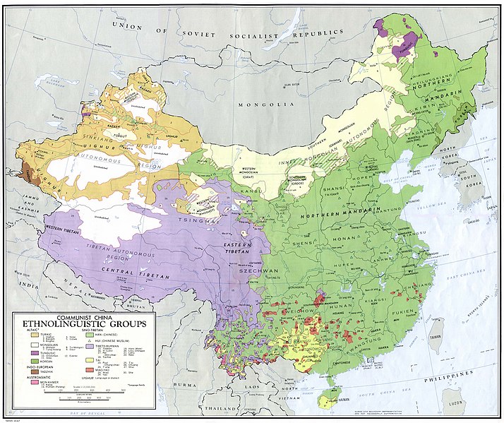
English: China - Ethnolinguistic Groups from People's Republic of China Map Folio. U.S. Central Intelligence Agency, Directorate of Intelligence, Office of Basic Geographic Intelligence, 1967. (960K)
The map shows the distribution of ethnolinguistic groups in mainland China according to the historical majority ethnic groups by region. Note this does not represent the current distribution due to age-long internal migration and assimilation. |
| Chhut-chhù | http://www.lib.utexas.edu/maps/china.html |
| Chok-chiá |
.jpg)
.jpg)
.jpg)
.jpg)
| 本圖像是中央情報局僱員的職務作品。作為美國聯邦政府的作品,本圖像或媒體屬於公有領域。
|

|
Tóng-àn le̍k-sú
Chhi̍h ji̍t-kî/sî-kan, khoàⁿ hit sî-chūn--ê tóng-àn.
| Ji̍t-kî/Sî-kan | 細張圖 | 寸尺 | Iōng-chiá | Chù-kái | |
|---|---|---|---|---|---|
| hiān-chāi | 2005-nî 6-goe̍h 23-ji̍t (pài-sì) 05:47 | | 3,031 × 2,544(959 KB) | Hottentot~commonswiki | Source: http://www.lib.utexas.edu/maps/china.html • China - Ethnolinguistic Groups from Communist China Map Folio. U.S. Central Intelligence Agency, Directorate of Intelligence, Office of Basic Geographic Intelligence, 1967. (960K) {{PD-USGov-CIA}} |
Iáⁿ-siōng liân-kiat
Bô poàⁿ ia̍h liân kàu chit tiuⁿ iáⁿ-siōng.
tóng-àn hō͘ lâng sái--ê chōng-hóng
Ē-kha--ê kî-thaⁿ wiki ēng tio̍h chit--ê tóng-àn:
- an.wikipedia.org hō͘ lâng ēng--ê chêng-hêng
- ast.wikipedia.org hō͘ lâng ēng--ê chêng-hêng
- azb.wikipedia.org hō͘ lâng ēng--ê chêng-hêng
- bg.wiktionary.org hō͘ lâng ēng--ê chêng-hêng
- da.wikipedia.org hō͘ lâng ēng--ê chêng-hêng
- de.wikipedia.org hō͘ lâng ēng--ê chêng-hêng
- el.wikipedia.org hō͘ lâng ēng--ê chêng-hêng
- en.wikipedia.org hō͘ lâng ēng--ê chêng-hêng
- en.wiktionary.org hō͘ lâng ēng--ê chêng-hêng
- fr.wikipedia.org hō͘ lâng ēng--ê chêng-hêng
- gcr.wikipedia.org hō͘ lâng ēng--ê chêng-hêng
- gl.wikipedia.org hō͘ lâng ēng--ê chêng-hêng
- hak.wikipedia.org hō͘ lâng ēng--ê chêng-hêng
- hyw.wikipedia.org hō͘ lâng ēng--ê chêng-hêng
- incubator.wikimedia.org hō͘ lâng ēng--ê chêng-hêng
- lt.wikipedia.org hō͘ lâng ēng--ê chêng-hêng
- lv.wikipedia.org hō͘ lâng ēng--ê chêng-hêng
- mk.wikipedia.org hō͘ lâng ēng--ê chêng-hêng
- nl.wikipedia.org hō͘ lâng ēng--ê chêng-hêng
- sr.wikipedia.org hō͘ lâng ēng--ê chêng-hêng
- ta.wikipedia.org hō͘ lâng ēng--ê chêng-hêng
- uk.wikipedia.org hō͘ lâng ēng--ê chêng-hêng
- vi.wiktionary.org hō͘ lâng ēng--ê chêng-hêng
- zh.wiktionary.org hō͘ lâng ēng--ê chêng-hêng