
tóng-àn:Satellite View of Japan 1999.jpg
Seng khoàⁿ chiàm-liōng: 469 × 599 siōng-sò͘. Kî-thaⁿ--ê kái-sek-tō͘: 188 × 240 siōng-sò͘ | 376 × 480 siōng-sò͘ | 601 × 768 siōng-sò͘ | 802 × 1,024 siōng-sò͘ | 1,638 × 2,092 siōng-sò͘.
Choân kái-sek-tō͘ (1,638 × 2,092 siōng-sò͘ , tóng-àn chiàm-liōng: 1.04 MB, MIME luī-hêng: image/jpeg)
|
|
Che sī tùi Wikimedia Commons ín--lâi ê chi̍t hūn tóng-àn. I tī hia ê kì-su̍t-ia̍h téng-bīn ê chu-sìn hián-sī ùi ē-té. |
Khài-iàu
| Soat-bêng |
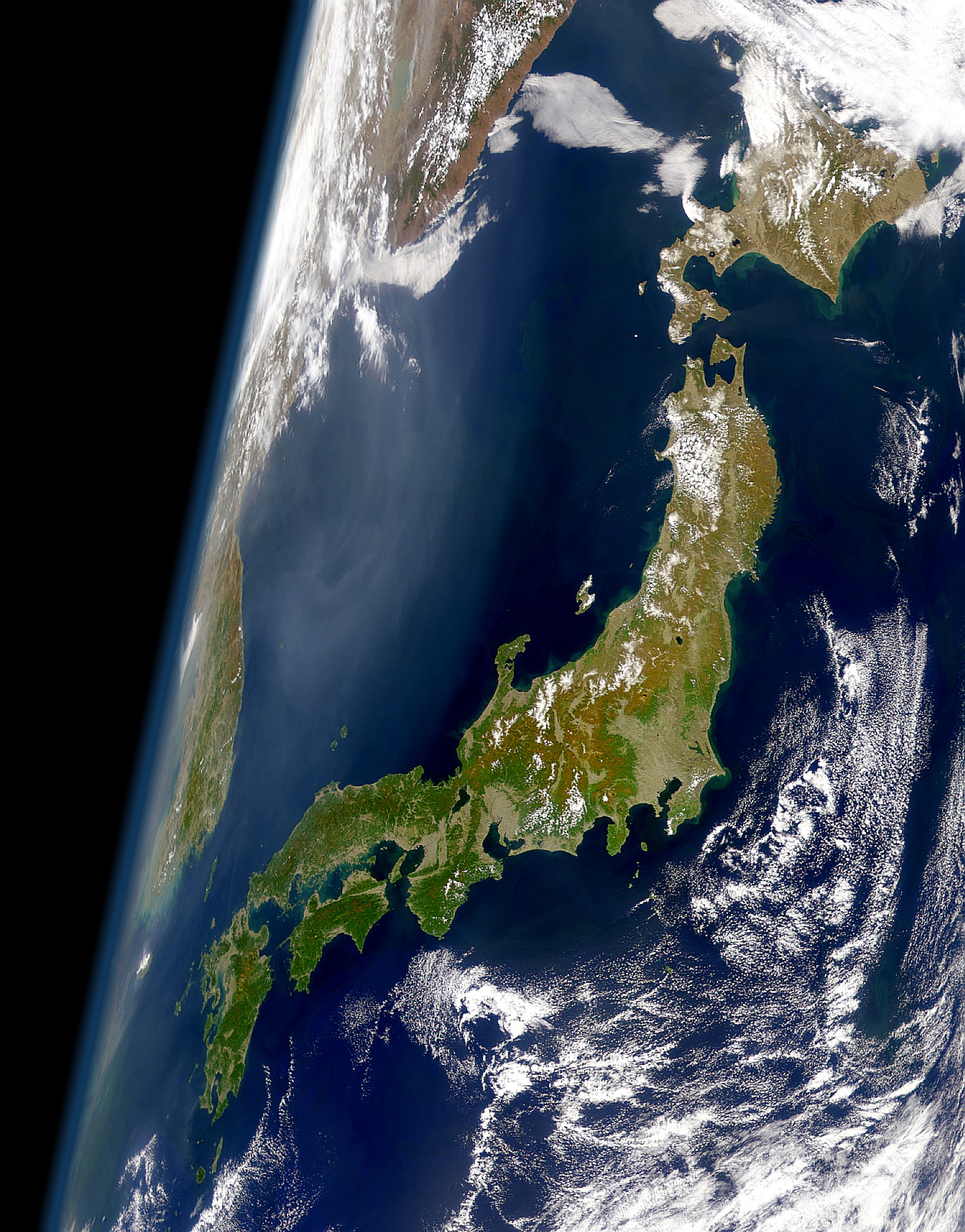
English: View of Japan taken from a satellite (1999)
日本語: 衛星から見た日本(1999年) |
| Ji̍t-kî | |
| Chhut-chhù | Cropped version of the high resolution variation of image found at: https://visibleearth.nasa.gov/images/52957/clear-view-of-japan |
| Chok-chiá | SeaWiFS Project, NASA/Goddard Space Flight Center, and ORBIMAGE |
Siū-khoân
| This image is from the Sea-viewing Wide Field-of-view Sensor (SeaWiFS) Project and more than 5 years old.
Satellite data captured by the SeaWIFS sensor are released into the public domain 5 years after capture. Data less than five years old can be re-used only for educational or scientific purposes; any commercial use of such images must be coordinated with GeoEye. [1] |
| This work has been released into the public domain by its copyright holder, GeoEye. This applies worldwide. 這可能在某些國家不合法,如果是的話: GeoEye授予任何人有權利使用此作品於任何用途,除受法律約束外,不受任何限制。
|
Tóng-àn le̍k-sú
Chhi̍h ji̍t-kî/sî-kan, khoàⁿ hit sî-chūn--ê tóng-àn.
| Ji̍t-kî/Sî-kan | 細張圖 | 寸尺 | Iōng-chiá | Chù-kái | |
|---|---|---|---|---|---|
| hiān-chāi | 2008-nî 1-goe̍h 26-ji̍t (pài-la̍k) 01:11 | | 1,638 × 2,092(1.04 MB) | Satelite of Love | {{Information |Description=View of Japan take from a satellite (1999) |Source=Cropped version of the high resolution variation of image found at: http://visibleearth.nasa.gov/cgi-bin/viewrecord?10466 |Date=Jan. 24, 2008 |Author= [[User:Satelite of Love|Sa |
Iáⁿ-siōng liân-kiat
Bô poàⁿ ia̍h liân kàu chit tiuⁿ iáⁿ-siōng.
tóng-àn hō͘ lâng sái--ê chōng-hóng
Ē-kha--ê kî-thaⁿ wiki ēng tio̍h chit--ê tóng-àn:
- af.wikipedia.org hō͘ lâng ēng--ê chêng-hêng
- am.wikipedia.org hō͘ lâng ēng--ê chêng-hêng
- ar.wikipedia.org hō͘ lâng ēng--ê chêng-hêng
- ast.wikipedia.org hō͘ lâng ēng--ê chêng-hêng
- azb.wikipedia.org hō͘ lâng ēng--ê chêng-hêng
- bat-smg.wikipedia.org hō͘ lâng ēng--ê chêng-hêng
- be-tarask.wikipedia.org hō͘ lâng ēng--ê chêng-hêng
- be.wikipedia.org hō͘ lâng ēng--ê chêng-hêng
- bg.wikipedia.org hō͘ lâng ēng--ê chêng-hêng
- bm.wikipedia.org hō͘ lâng ēng--ê chêng-hêng
- bn.wikipedia.org hō͘ lâng ēng--ê chêng-hêng
- bo.wikipedia.org hō͘ lâng ēng--ê chêng-hêng
- br.wiktionary.org hō͘ lâng ēng--ê chêng-hêng
- bs.wikipedia.org hō͘ lâng ēng--ê chêng-hêng
- ca.wikipedia.org hō͘ lâng ēng--ê chêng-hêng
- ca.wikinews.org hō͘ lâng ēng--ê chêng-hêng
- cs.wikipedia.org hō͘ lâng ēng--ê chêng-hêng
- da.wikipedia.org hō͘ lâng ēng--ê chêng-hêng
- de.wikipedia.org hō͘ lâng ēng--ê chêng-hêng
- el.wikipedia.org hō͘ lâng ēng--ê chêng-hêng
- en.wikipedia.org hō͘ lâng ēng--ê chêng-hêng
- en.wikibooks.org hō͘ lâng ēng--ê chêng-hêng
- en.wikiquote.org hō͘ lâng ēng--ê chêng-hêng
- eo.wikipedia.org hō͘ lâng ēng--ê chêng-hêng
- es.wikipedia.org hō͘ lâng ēng--ê chêng-hêng
- et.wikipedia.org hō͘ lâng ēng--ê chêng-hêng
- fa.wikipedia.org hō͘ lâng ēng--ê chêng-hêng
- fi.wikipedia.org hō͘ lâng ēng--ê chêng-hêng
- fr.wikipedia.org hō͘ lâng ēng--ê chêng-hêng
- gl.wikipedia.org hō͘ lâng ēng--ê chêng-hêng
- hi.wikipedia.org hō͘ lâng ēng--ê chêng-hêng
- hr.wikipedia.org hō͘ lâng ēng--ê chêng-hêng
- hy.wikipedia.org hō͘ lâng ēng--ê chêng-hêng
- id.wikipedia.org hō͘ lâng ēng--ê chêng-hêng
檢視此檔案的更多全域使用狀況。