
tóng-àn:Xinjiang Internment Map, US-Aus Gov Assessment.jpg
Seng khoàⁿ chiàm-liōng: 800 × 495 siōng-sò͘. Kî-thaⁿ--ê kái-sek-tō͘: 320 × 198 siōng-sò͘ | 640 × 396 siōng-sò͘ | 1,024 × 634 siōng-sò͘ | 1,280 × 792 siōng-sò͘ | 2,048 × 1,267 siōng-sò͘.
Choân kái-sek-tō͘ (2,048 × 1,267 siōng-sò͘ , tóng-àn chiàm-liōng: 150 KB, MIME luī-hêng: image/jpeg)
|
|
Che sī tùi Wikimedia Commons ín--lâi ê chi̍t hūn tóng-àn. I tī hia ê kì-su̍t-ia̍h téng-bīn ê chu-sìn hián-sī ùi ē-té. |
Khài-iàu
| Soat-bêng |
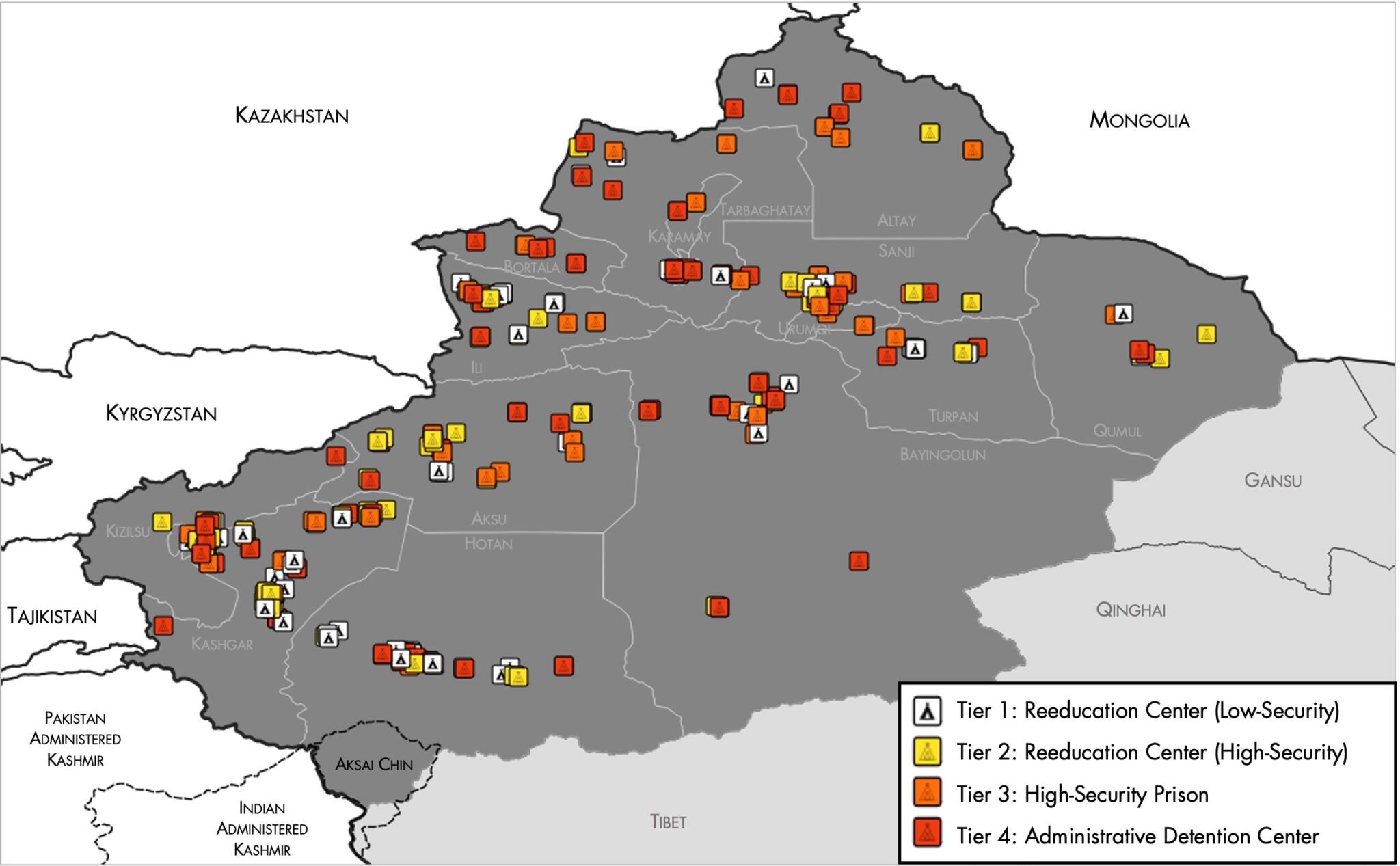
English: Map of the Xinjiang Internment Camps created by the RAND Corporation based on data collected by the US National Geospatial Intelligence Agency and the Australian Strategic Policy Institute. Open source here. |
||||||||
| Ji̍t-kî | |||||||||
| Chhut-chhù | https://www.tearline.mil/public_page/xinjiang-nighttime-1/ | ||||||||
| Chok-chiá | National Geospatial Intelligence Agency, using data from the Australian Strategic Policy Institute, and administrative boundaries from GADM. | ||||||||
| 授權允准 (Bô siŏh-huòi sāi ciā ùng-giông) |
|


Tóng-àn le̍k-sú
Chhi̍h ji̍t-kî/sî-kan, khoàⁿ hit sî-chūn--ê tóng-àn.
| Ji̍t-kî/Sî-kan | 細張圖 | 寸尺 | Iōng-chiá | Chù-kái | |
|---|---|---|---|---|---|
| hiān-chāi | 2021-nî 5-goe̍h 2-ji̍t (lé-pài) 05:05 | | 2,048 × 1,267(150 KB) | Abovfold | Uploaded a work by {{w|National Geospatial Intelligence Agency}}, using data from the {{w|Australian Strategic Policy Institute}}, and administrative boundaries from {{w|GADM}}. from https://www.tearline.mil/public_page/xinjiang-nighttime-1/ with UploadWizard |
Iáⁿ-siōng liân-kiat
Bô poàⁿ ia̍h liân kàu chit tiuⁿ iáⁿ-siōng.
tóng-àn hō͘ lâng sái--ê chōng-hóng
Ē-kha--ê kî-thaⁿ wiki ēng tio̍h chit--ê tóng-àn:
- ba.wikipedia.org hō͘ lâng ēng--ê chêng-hêng
- br.wikipedia.org hō͘ lâng ēng--ê chêng-hêng
- cs.wikipedia.org hō͘ lâng ēng--ê chêng-hêng
- de.wikipedia.org hō͘ lâng ēng--ê chêng-hêng
- el.wikipedia.org hō͘ lâng ēng--ê chêng-hêng
- en.wikipedia.org hō͘ lâng ēng--ê chêng-hêng
- es.wikipedia.org hō͘ lâng ēng--ê chêng-hêng
- fi.wikipedia.org hō͘ lâng ēng--ê chêng-hêng
- fr.wikipedia.org hō͘ lâng ēng--ê chêng-hêng
- ga.wikipedia.org hō͘ lâng ēng--ê chêng-hêng
- he.wikipedia.org hō͘ lâng ēng--ê chêng-hêng
- km.wikipedia.org hō͘ lâng ēng--ê chêng-hêng
- nl.wikipedia.org hō͘ lâng ēng--ê chêng-hêng
- or.wikipedia.org hō͘ lâng ēng--ê chêng-hêng
- pl.wikipedia.org hō͘ lâng ēng--ê chêng-hêng
- pt.wikipedia.org hō͘ lâng ēng--ê chêng-hêng
- ru.wikinews.org hō͘ lâng ēng--ê chêng-hêng
- sv.wikipedia.org hō͘ lâng ēng--ê chêng-hêng
- szl.wikipedia.org hō͘ lâng ēng--ê chêng-hêng
- tr.wikipedia.org hō͘ lâng ēng--ê chêng-hêng
- www.wikidata.org hō͘ lâng ēng--ê chêng-hêng