"Courlay" pán-pún chi-kan bô-kāng--ê tē-hng
刪去的內容 新增的內容
~ wikidata:Q1146377: +INSEE data (thong-kòe P374) +hū-kīn (chiàu P47) |
~ Chiàu WIKIDATA ê chu-liāu siá--ê |
||
| Tē 3 chōa: | Tē 3 chōa: | ||
| image = |
| image = |
||
| image_caption = |
| image_caption = |
||
| image_map = |
| image_map = Map commune FR insee code 79103.png |
||
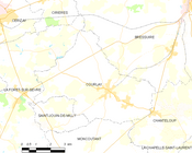
| map_caption = Courlay |
| map_caption = Courlay só͘-chāi tē-tô͘ |
||
| image_flag = |
| image_flag = |
||
| image_shield = |
| image_shield = Blason ville fr Courlay 79.svg |
||
| latd = 46<!-- keng-hūi-tō͘--> |
| latd = 46<!-- keng-hūi-tō͘--> |
||
| latm = 46 |
| latm = 46 |
||
Hiān-chú-sî (2017-nî 3-goe̍h 12-ji̍t (lé-pài) 09:14) ê siu-tēng-pún
| Courlay | |||
| — Commune — | |||
|
|||
 |
|||
| Courlay tī Hoat-kok ê tāi-lio̍k ūi-tì | |||
| Keng-hūi-tō͘: 46°46′46″N 0°34′1″W / 46.77944°N 0.56694°W | |||
| Kok-ka | |||
|---|---|---|---|
| Toā-khu | Poitou-Charentes | ||
| Koān | Deux-Sèvres | ||
| Kūn | |||
Courlay sī ūi-tī Hoat-kok Poitou-Charentes toā-khu Deux-Sèvres koān ê chi̍t ê commune.
Tē-lí[siu-kái | kái goân-sí-bé]
Tī Courlay ê sì-ûi ū Bressuire, Chanteloup, La Forêt-sur-Sèvre, Moncoutant, kap Saint-Jouin-de-Milly téng siâⁿ-chhī he̍k-chiá chng-siā.
Jîn-kháu[siu-kái | kái goân-sí-bé]
| Nî-tō͘ | 1968 | 1975 | 1982 | 1990 | 1999 | 2007 | 2012 |
|---|---|---|---|---|---|---|---|
| Jîn-kháu | 2,205 | 2,391 | 2,475 | 2,558 | 2,394 | 2,356 | 2,427 |
| Bi̍t-tō͘ (jîn-kháu/km²) | 74.8 | 81.2 | 84.0 | 86.8 | 81.3 | 80.0 | 82.4 |
Chham-khó[siu-kái | kái goân-sí-bé]
- "Commune de Courlay (79103) - Dossier complet". INSEE. 2016-06-05 khòaⁿ--ê.


