
tóng-àn:Allegheny River Lock and Dam No.4.jpg
Bô khah koân ê kái-sek-tō͘.
Allegheny_River_Lock_and_Dam_No.4.jpg (720 × 480 siōng-sò͘ , tóng-àn chiàm-liōng: 132 KB, MIME luī-hêng: image/jpeg)
|
|
Che sī tùi Wikimedia Commons ín--lâi ê chi̍t hūn tóng-àn. I tī hia ê kì-su̍t-ia̍h téng-bīn ê chu-sìn hián-sī ùi ē-té. |
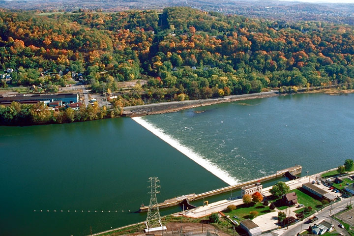
| Soat-bêng |
English: Lock and Dam Number 4 on the Allegheny River, Allegheny County, Pennsylvania, United States. Lock and Dam 4 was built from 1920-27, and opened in 1927. |
|||
| Chhut-chhù |
U.S. Army Corps of Engineers Digital Visual Library Image page Image description page |
|||
| Chok-chiá | U.S. Army Corps of Engineers | |||
| 授權允准 (Bô siŏh-huòi sāi ciā ùng-giông) |
|
| 目標地點 | | 位於此地的本圖片與其他圖片: OpenStreetMap |
|---|
Tóng-àn le̍k-sú
Chhi̍h ji̍t-kî/sî-kan, khoàⁿ hit sî-chūn--ê tóng-àn.
| Ji̍t-kî/Sî-kan | 細張圖 | 寸尺 | Iōng-chiá | Chù-kái | |
|---|---|---|---|---|---|
| hiān-chāi | 2009-nî 11-goe̍h 7-ji̍t (pài-la̍k) 06:31 | | 720 × 480(132 KB) | Geneisner | {{Information |Description={{en|1=Lock and Dam Number 4 on the Allegheny River, Allegheny County, Pennsylvania, United States. Lock and Dam 4 was built from 1920-27, and opened in 1927.}} |Source=U.S. Army Corps of Engineers Digital Visual Library [http: |
Iáⁿ-siōng liân-kiat
Í-hā ê ia̍h liân kàu chit ê iáⁿ-siōng:
tóng-àn hō͘ lâng sái--ê chōng-hóng
Ē-kha--ê kî-thaⁿ wiki ēng tio̍h chit--ê tóng-àn:
- ar.wikipedia.org hō͘ lâng ēng--ê chêng-hêng
- azb.wikipedia.org hō͘ lâng ēng--ê chêng-hêng
- ca.wikipedia.org hō͘ lâng ēng--ê chêng-hêng
- ceb.wikipedia.org hō͘ lâng ēng--ê chêng-hêng
- ce.wikipedia.org hō͘ lâng ēng--ê chêng-hêng
- ch.wikipedia.org hō͘ lâng ēng--ê chêng-hêng
- cs.wikipedia.org hō͘ lâng ēng--ê chêng-hêng
- cy.wikipedia.org hō͘ lâng ēng--ê chêng-hêng
- de.wikipedia.org hō͘ lâng ēng--ê chêng-hêng
- en.wikipedia.org hō͘ lâng ēng--ê chêng-hêng
- Lower Burrell, Pennsylvania
- National Register of Historic Places listings in Allegheny County, Pennsylvania
- National Register of Historic Places listings in Westmoreland County, Pennsylvania
- Natrona, Pennsylvania
- Allegheny River Lock and Dam No. 4
- User talk:Dthomsen8/List PA Test
- User:Smallbones/PA Gallery
- eu.wikipedia.org hō͘ lâng ēng--ê chêng-hêng
- fr.wikipedia.org hō͘ lâng ēng--ê chêng-hêng
- ht.wikipedia.org hō͘ lâng ēng--ê chêng-hêng
- it.wikipedia.org hō͘ lâng ēng--ê chêng-hêng
- lld.wikipedia.org hō͘ lâng ēng--ê chêng-hêng
- pl.wikipedia.org hō͘ lâng ēng--ê chêng-hêng
- pt.wikipedia.org hō͘ lâng ēng--ê chêng-hêng
- simple.wikipedia.org hō͘ lâng ēng--ê chêng-hêng
- sr.wikipedia.org hō͘ lâng ēng--ê chêng-hêng
- sv.wikipedia.org hō͘ lâng ēng--ê chêng-hêng
- tl.wikipedia.org hō͘ lâng ēng--ê chêng-hêng
- tr.wikipedia.org hō͘ lâng ēng--ê chêng-hêng
- tt.wikipedia.org hō͘ lâng ēng--ê chêng-hêng
- uk.wikipedia.org hō͘ lâng ēng--ê chêng-hêng
- uz.wikipedia.org hō͘ lâng ēng--ê chêng-hêng
- vi.wikipedia.org hō͘ lâng ēng--ê chêng-hêng
- vo.wikipedia.org hō͘ lâng ēng--ê chêng-hêng
- www.wikidata.org hō͘ lâng ēng--ê chêng-hêng