
tóng-àn:Anderson Manor - geograph.org.uk - 608301.jpg
Bô khah koân ê kái-sek-tō͘.
Anderson_Manor_-_geograph.org.uk_-_608301.jpg (640 × 426 siōng-sò͘ , tóng-àn chiàm-liōng: 197 KB, MIME luī-hêng: image/jpeg)
|
|
Che sī tùi Wikimedia Commons ín--lâi ê chi̍t hūn tóng-àn. I tī hia ê kì-su̍t-ia̍h téng-bīn ê chu-sìn hián-sī ùi ē-té. |
Khài-iàu
| Soat-bêng |
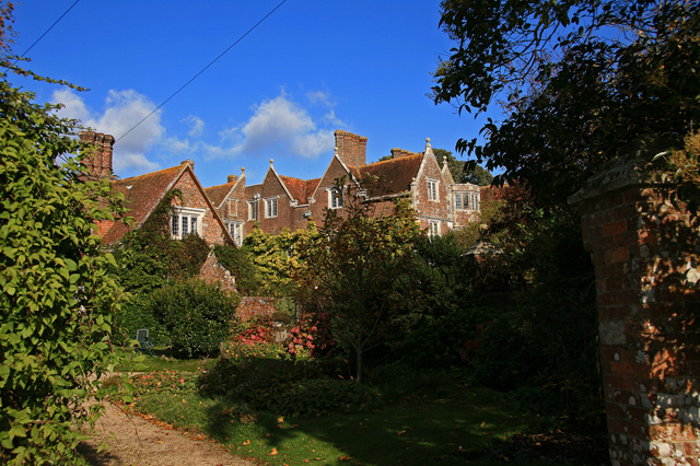
English: Anderson Manor Anderson Manor was built in 1622 for John Tregonwell, and was described three years later in Coker's Survey of Dorsetshire, as a 'faire newe house'. In more recent times it was taken over by the War Dept. during the Second World War, and became the headquarters for the Small Scale Raiding Force of 62 Commando. After the SSRF disbanded in 1943, Anderson Manor ended its wartime role as Station 62 under the Special Operations Executive (S.O.E.). The house is Grade I Listed.
|
|
| Ji̍t-kî | ||
| Chhut-chhù | From geograph.org.uk | |
| Chok-chiá | Mike Searle | |
| Biĕu-sê miàng-sáng (由许可协议要求) | Mike Searle / Anderson Manor / | |
| 拍攝地點 | | 位於此地的本圖片與其他圖片: OpenStreetMap |
|---|
_heading:22.00&language=nan)
| 目標地點 | | 位於此地的本圖片與其他圖片: OpenStreetMap |
|---|
_heading:22.00&language=nan)
Siū-khoân

|
此檔案採用創用CC 姓名標示-相同方式分享 2.0 通用版授權條款。
Biĕu-sê miàng-sáng: Mike Searle
- 你會使自由:
- 分享 – kho͘-pih, hoat-pò͘ kap thoân-pò͘ pún chok
- 重新修改 – kái-pian pún chok-phín
- Àn i-hā ê tiâu-kiāⁿ
- 標示名姓 – 您必須指名出正確的製作者,和提供授權條款的連結,以及表示是否有對內容上做出變更。您可以用任何合理的方式來行動,但不得以任何方式表明授權條款是對您許可或是由您所使用。
- 仝款方式方享 – Lí nā kái-tōng, piàn-khoán, he̍k-chiá kun-kù pún chok chhòng-chō, lí kaⁿ-taⁿ ē-tàng ēng kap pún chok kâng-khoán he̍k-chiá saⁿ-chhiūⁿ ê hí-khó lâi hoat-pò͘ chò--chhut-lâi ê chok-phín.
Tóng-àn le̍k-sú
Chhi̍h ji̍t-kî/sî-kan, khoàⁿ hit sî-chūn--ê tóng-àn.
| Ji̍t-kî/Sî-kan | 細張圖 | 寸尺 | Iōng-chiá | Chù-kái | |
|---|---|---|---|---|---|
| hiān-chāi | 2011-nî 2-goe̍h 6-ji̍t (lé-pài) 22:22 | | 640 × 426(197 KB) | GeographBot | == {{int:filedesc}} == {{Information |description={{en|1=Anderson Manor Anderson Manor was built in 1622 for John Tregonwell, and was described three years later in Coker's Survey of Dorsetshire, as a 'faire newe house'. In more recent times it was taken |
Iáⁿ-siōng liân-kiat
Í-hā ê ia̍h liân kàu chit ê iáⁿ-siōng:
tóng-àn hō͘ lâng sái--ê chōng-hóng
Ē-kha--ê kî-thaⁿ wiki ēng tio̍h chit--ê tóng-àn:
- ceb.wikipedia.org hō͘ lâng ēng--ê chêng-hêng
- cy.wikipedia.org hō͘ lâng ēng--ê chêng-hêng
- dag.wikipedia.org hō͘ lâng ēng--ê chêng-hêng
- da.wikipedia.org hō͘ lâng ēng--ê chêng-hêng
- en.wikipedia.org hō͘ lâng ēng--ê chêng-hêng
- fr.wikipedia.org hō͘ lâng ēng--ê chêng-hêng
- it.wikipedia.org hō͘ lâng ēng--ê chêng-hêng
- nl.wikipedia.org hō͘ lâng ēng--ê chêng-hêng
- pl.wikipedia.org hō͘ lâng ēng--ê chêng-hêng
- ur.wikipedia.org hō͘ lâng ēng--ê chêng-hêng
- www.wikidata.org hō͘ lâng ēng--ê chêng-hêng