
tóng-àn:Bedfordshire UK location map.svg

此 SVG 檔案的 PNG 預覽的大小:530 × 599 siōng-sò͘。 Kî-thaⁿ--ê kái-sek-tō͘: 212 × 240 siōng-sò͘ | 425 × 480 siōng-sò͘ | 679 × 768 siōng-sò͘ | 906 × 1,024 siōng-sò͘ | 1,812 × 2,048 siōng-sò͘ | 1,120 × 1,266 siōng-sò͘.
Choân kái-sek-tō͘ (SVG ùng-giông, chék-cháung: 1,120 × 1,266 chuông-só, ùng-giông duâi-nâung:1.34 MB)
|
|
Che sī tùi Wikimedia Commons ín--lâi ê chi̍t hūn tóng-àn. I tī hia ê kì-su̍t-ia̍h téng-bīn ê chu-sìn hián-sī ùi ē-té. |
| Soat-bêng |
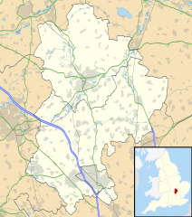
Map of Bedfordshire, UK with the following information shown:
Equirectangular map projection on WGS 84 datum, with N/S stretched 160% Geographic limits:
|
| Ji̍t-kî | |
| Chhut-chhù |
|
| Chok-chiá | Nilfanion, created using Ordnance Survey data |
| 授權允准 (Bô siŏh-huòi sāi ciā ùng-giông) |
此檔案採用創用CC 姓名標示-相同方式分享 3.0 未在地化版本授權條款。 Biĕu-sê miàng-sáng: Contains Ordnance Survey data © Crown copyright and database right
|
| 其他版本 | File:Bedfordshire UK district map (blank).svg - Blank map with administrative borders only. |
.svg)
Tóng-àn le̍k-sú
Chhi̍h ji̍t-kî/sî-kan, khoàⁿ hit sî-chūn--ê tóng-àn.
| Ji̍t-kî/Sî-kan | 細張圖 | 寸尺 | Iōng-chiá | Chù-kái | |
|---|---|---|---|---|---|
| hiān-chāi | 2010-nî 9-goe̍h 26-ji̍t (lé-pài) 17:56 | | 1,120 × 1,266(1.34 MB) | Nilfanion | Tweak m-ways .. again.. |
| 2010-nî 9-goe̍h 6-ji̍t (pài-it) 23:56 |  | 1,120 × 1,266(1.34 MB) | Nilfanion | Tweaking urban areas, road colours and boundary lines | |
| 2010-nî 9-goe̍h 4-ji̍t (pài-la̍k) 20:36 |  | 1,120 × 1,266(1.29 MB) | Nilfanion | {{Information |Description=Map of Bedfordshire, UK with the following information shown: *Administrative borders *Coastline, lakes and rivers *Motorways, primary routes and A-roads *Urban areas Equirectangular map projection on WGS 84 |
Iáⁿ-siōng liân-kiat
超過 100 個頁面有用到此檔案。 下列清單只列出前 100 筆有用到此檔案的頁面。 您也可以檢視完整清單。
- Ampthill
- Arlesey
- Aspley Guise
- Aspley Heath
- Astwick
- Barton-le-Clay
- Battlesden
- Biddenham
- Biggleswade
- Billington
- Bletsoe
- Blunham
- Bolnhurst and Keysoe
- Brickhill
- Brogborough
- Bromham (Bedfordshire)
- Caddington
- Campton and Chicksands
- Cardington (Bedfordshire)
- Carlton with Chellington
- Chalgrave
- Chalton
- Clapham (Bedfordshire)
- Clifton (Bedfordshire)
- Clophill
- Colmworth
- Cople
- Cranfield
- Dean and Shelton
- Dunstable
- Dunton (Bedfordshire)
- Eastcotts
- Eaton Bray
- Edworth
- Eggington
- Elstow
- Eversholt
- Everton (Bedfordshire)
- Eyeworth
- Felmersham
- Flitton and Greenfield
- Flitwick
- Gravenhurst (Bedfordshire)
- Great Barford
- Great Denham
- Harlington (Bedfordshire)
- Harrold (Bedfordshire)
- Haynes (Bedfordshire)
- Heath and Reach
- Henlow
- Hockliffe
- Houghton Conquest
- Houghton Regis
- Hulcote and Salford
- Husborne Crawley
- Hyde (Bedfordshire)
- Kempston
- Kempston Rural
- Kensworth
- Knotting and Souldrop
- Langford (Bedfordshire)
- Leighton-Linslade
- Lidlington
- Little Barford
- Little Staughton
- Marston Moretaine
- Maulden
- Melchbourne and Yielden
- Meppershall
- Millbrook (Bedfordshire)
- Milton Bryan
- Milton Ernest
- Moggerhanger
- Northill
- Oakley (Bedfordshire)
- Odell (Bedfordshire)
- Old Warden
- Pavenham
- Pertenhall
- Podington
- Potsgrove
- Potton
- Pulloxhill
- Ravensden
- Renhold
- Ridgmont
- Riseley
- Roxton (Bedfordshire)
- Sandy (Bedfordshire)
- Sharnbrook
- Shefford
- Shillington (Bedfordshire)
- Silsoe
- Slip End
- Southill
- Stagsden
- Stanbridge
- Staploe
- Steppingley
- Stevington
檢視連結到這個檔案的更多連結。
tóng-àn hō͘ lâng sái--ê chōng-hóng
Ē-kha--ê kî-thaⁿ wiki ēng tio̍h chit--ê tóng-àn:
- af.wikipedia.org hō͘ lâng ēng--ê chêng-hêng
- ar.wikipedia.org hō͘ lâng ēng--ê chêng-hêng
- bg.wikipedia.org hō͘ lâng ēng--ê chêng-hêng
- bn.wikipedia.org hō͘ lâng ēng--ê chêng-hêng
- ceb.wikipedia.org hō͘ lâng ēng--ê chêng-hêng
- en.wikipedia.org hō͘ lâng ēng--ê chêng-hêng
- Bedford
- Bushmead Priory
- Beeston, Bedfordshire
- Luton Airport
- Flitwick
- Kempston
- Biggleswade
- Sandy, Bedfordshire
- Little Barford
- Ampthill
- Leighton Buzzard
- Woburn, Bedfordshire
- Eaton Bray
- Linslade
- Southcote, Bedfordshire
- Woburn Sands
- Studham
- Potton
- Old Warden
- Billington, Bedfordshire
- Eversholt
- RAF Chicksands
- RAF Henlow
- Bromham, Bedfordshire
- Everton, Bedfordshire
- List of places in Bedfordshire
- Stagsden
- Clapham, Bedfordshire
- Pertenhall
- RAE Bedford
- Hockliffe
- Houghton House
- Luton Hoo
- Campton, Bedfordshire
- Haynes, Bedfordshire
- Civil parishes in Bedfordshire
- Wootton, Bedfordshire
- Cranfield
- Hundred of Biggleswade
- Cockayne Hatley
- Odell, Bedfordshire
- Wrest Park
- Cardington, Bedfordshire
檢視此檔案的更多全域使用狀況。