
tóng-àn:Island of Ireland location map Clare.svg

此 SVG 檔案的 PNG 預覽的大小:481 × 599 siōng-sò͘。 Kî-thaⁿ--ê kái-sek-tō͘: 192 × 240 siōng-sò͘ | 385 × 480 siōng-sò͘ | 616 × 768 siōng-sò͘ | 822 × 1,024 siōng-sò͘ | 1,643 × 2,048 siōng-sò͘ | 1,450 × 1,807 siōng-sò͘.
Choân kái-sek-tō͘ (SVG ùng-giông, chék-cháung: 1,450 × 1,807 chuông-só, ùng-giông duâi-nâung:642 KB)
|
|
Che sī tùi Wikimedia Commons ín--lâi ê chi̍t hūn tóng-àn. I tī hia ê kì-su̍t-ia̍h téng-bīn ê chu-sìn hián-sī ùi ē-té. |
| Soat-bêng |
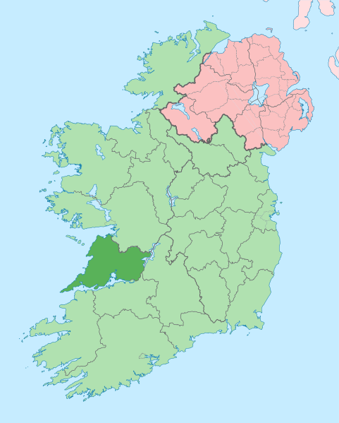
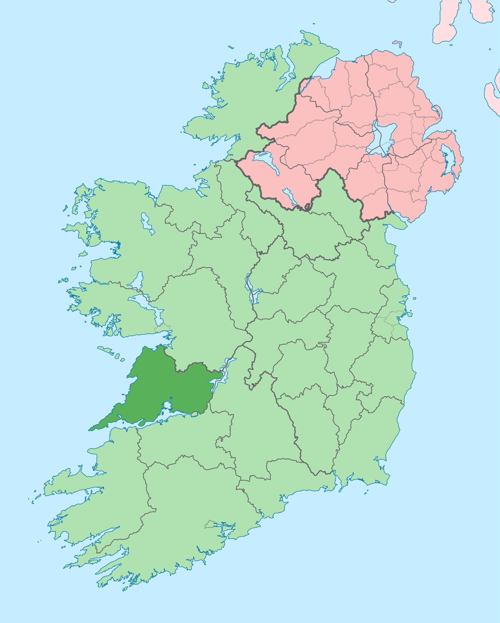
English: The island of Ireland, showing international border between Ireland and Northern Ireland, traditional provinces, traditional counties, and local authority areas in Ireland and Northern Ireland. |
| Ji̍t-kî | (UTC) |
| Chhut-chhù | |
| Chok-chiá |
|
| 這是一張修飾過的圖片,即本圖片是用軟體修改過後的版本,修改的方式或內容有:Coloured in regions with county of article highlighted。原版圖片來源:Island of Ireland location map.svg。修改者:Mabuska。
|
我,本作品的著作權持有者,決定用以下授權條款發佈本作品:
此檔案採用創用CC 姓名標示-相同方式分享 3.0 未在地化版本授權條款。
- 你會使自由:
- 分享 – kho͘-pih, hoat-pò͘ kap thoân-pò͘ pún chok
- 重新修改 – kái-pian pún chok-phín
- Àn i-hā ê tiâu-kiāⁿ
- 標示名姓 – 您必須指名出正確的製作者,和提供授權條款的連結,以及表示是否有對內容上做出變更。您可以用任何合理的方式來行動,但不得以任何方式表明授權條款是對您許可或是由您所使用。
- 仝款方式方享 – Lí nā kái-tōng, piàn-khoán, he̍k-chiá kun-kù pún chok chhòng-chō, lí kaⁿ-taⁿ ē-tàng ēng kap pún chok kâng-khoán he̍k-chiá saⁿ-chhiūⁿ ê hí-khó lâi hoat-pò͘ chò--chhut-lâi ê chok-phín.
原始上傳日誌
This image is a derivative work of the following images:
- File:Island_of_Ireland_location_map.svg licensed with Cc-by-sa-3.0
- 2010-03-06T20:43:33Z Rannpháirtí anaithnid 1450x1807 (679207 Bytes) Fix incorrectly coloured isands.
- 2010-03-03T22:19:29Z Rannpháirtí anaithnid 1450x1807 (679744 Bytes) {{Information |Description={{de|Positionskarte von [[:de:Irland|Irland]]}} Quadratische Plattkarte, N-S-Streckung 170 %. Geographische Begrenzung der Karte: * N: 55.6° N * S: 51.2° N * W: 11.0° W * O: 5.0° W {{en|Location
Uploaded with derivativeFX
Tóng-àn le̍k-sú
Chhi̍h ji̍t-kî/sî-kan, khoàⁿ hit sî-chūn--ê tóng-àn.
| Ji̍t-kî/Sî-kan | 細張圖 | 寸尺 | Iōng-chiá | Chù-kái | |
|---|---|---|---|---|---|
| hiān-chāi | 2020-nî 6-goe̍h 28-ji̍t (lé-pài) 14:05 | | 1,450 × 1,807(642 KB) | Chipmunkdavis | Colouring in Aughinish |
| 2020-nî 6-goe̍h 26-ji̍t (pài-gō·) 15:54 |  | 1,450 × 1,807(642 KB) | Chipmunkdavis | Rmv stray number in code | |
| 2020-nî 6-goe̍h 26-ji̍t (pài-gō·) 15:26 |  | 1,450 × 1,807(642 KB) | Chipmunkdavis | Merging Tipperary and Waterford shapes | |
| 2020-nî 6-goe̍h 26-ji̍t (pài-gō·) 12:55 |  | 1,450 × 1,807(643 KB) | Chipmunkdavis | Removing Limerick City | |
| 2020-nî 6-goe̍h 25-ji̍t (pài-sì) 16:21 |  | 1,450 × 1,807(643 KB) | Chipmunkdavis | Per the Local Government Reform Act 2014, removing the Tipperary border and the Waterford City border. | |
| 2020-nî 6-goe̍h 25-ji̍t (pài-sì) 16:10 |  | 1,450 × 1,807(646 KB) | Chipmunkdavis | Removing lots of stray objects. Fixing location of Clare and one island slightly. | |
| 2020-nî 6-goe̍h 25-ji̍t (pài-sì) 15:45 |  | 1,450 × 1,807(695 KB) | Chipmunkdavis | Colour islands in, place all islands and borders in groups, remove some blank and redundant shapes | |
| 2010-nî 7-goe̍h 19-ji̍t (pài-it) 00:41 |  | 1,450 × 1,807(815 KB) | Mabuska | {{Information |Description={{en|The island of Ireland, showing international border between Northern Ireland and Republic of Ireland, traditional provinces, traditional counties, and local authority areas in the Republic of Ireland and Northern Ireland.}} |
Iáⁿ-siōng liân-kiat
Í-hā ê ia̍h liân kàu chit ê iáⁿ-siōng:
tóng-àn hō͘ lâng sái--ê chōng-hóng
Ē-kha--ê kî-thaⁿ wiki ēng tio̍h chit--ê tóng-àn:
- ar.wikipedia.org hō͘ lâng ēng--ê chêng-hêng
- ast.wikipedia.org hō͘ lâng ēng--ê chêng-hêng
- bg.wikipedia.org hō͘ lâng ēng--ê chêng-hêng
- ca.wikipedia.org hō͘ lâng ēng--ê chêng-hêng
- ceb.wikipedia.org hō͘ lâng ēng--ê chêng-hêng
- cs.wikipedia.org hō͘ lâng ēng--ê chêng-hêng
- en.wikipedia.org hō͘ lâng ēng--ê chêng-hêng
- County Clare
- Inagh
- Ennis
- List of Ireland-related topics
- Shannon, County Clare
- Lissycasey
- Shannon Free Zone
- Lisdoonvarna
- Cratloe
- Doolin
- Kilfenora
- Ballyvaughan
- Carran
- Kilkee
- Kilrush
- Clarecastle
- Ennistymon
- Killaloe, County Clare
- Lahinch
- Liscannor
- Mountshannon
- Newmarket-on-Fergus
- O'Brien's Bridge
- Spanish Point, County Clare
- Aughinish, County Clare
檢視此檔案的更多全域使用狀況。