
tóng-àn:Kanawha Ohio confluence.jpg

Seng khoàⁿ chiàm-liōng: 751 × 600 siōng-sò͘. Kî-thaⁿ--ê kái-sek-tō͘: 301 × 240 siōng-sò͘ | 601 × 480 siōng-sò͘ | 962 × 768 siōng-sò͘ | 1,280 × 1,022 siōng-sò͘ | 1,500 × 1,198 siōng-sò͘.
Choân kái-sek-tō͘ (1,500 × 1,198 siōng-sò͘ , tóng-àn chiàm-liōng: 724 KB, MIME luī-hêng: image/jpeg)
|
|
Che sī tùi Wikimedia Commons ín--lâi ê chi̍t hūn tóng-àn. I tī hia ê kì-su̍t-ia̍h téng-bīn ê chu-sìn hián-sī ùi ē-té. |
Khài-iàu
| Soat-bêng |
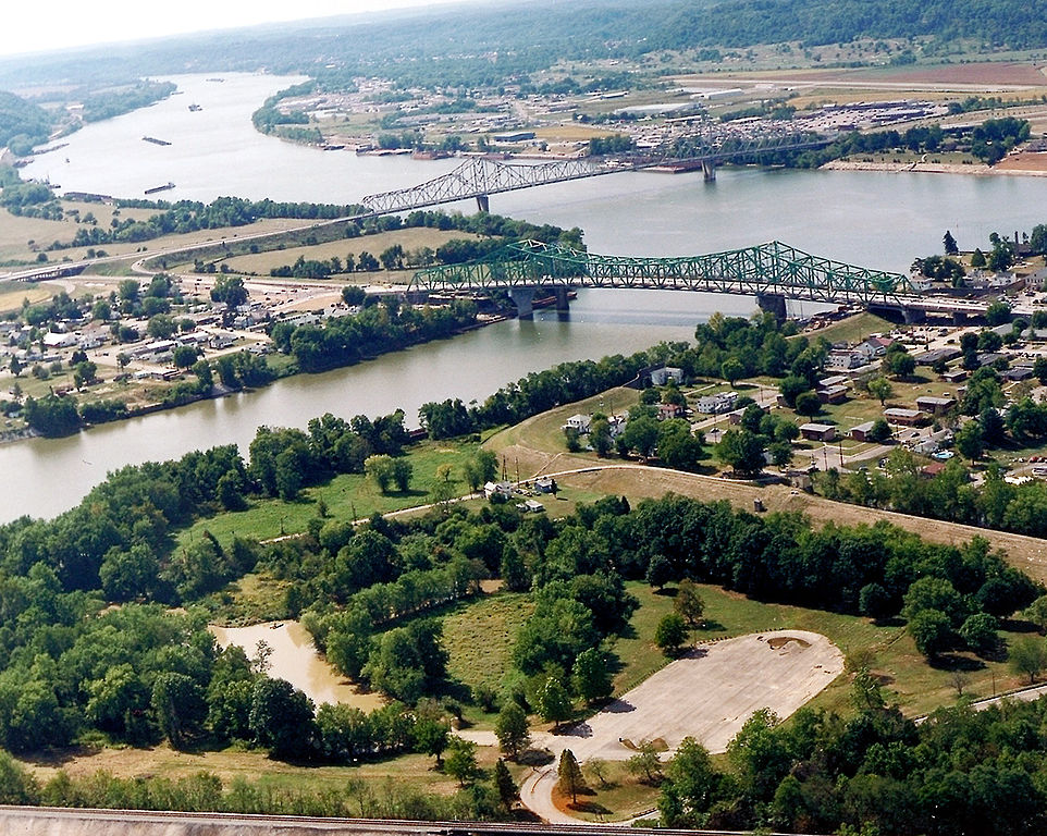
English: The confluence of the Kanawha and Ohio Rivers. The Kanawha River flows in from the left of the picture and joins the Ohio, meandering off in the distance. The town of Point Pleasant, West Virginia is in the foreground on the right. Henderson, West Virginia is on the left. The Ohio River forms the boundary between West Virginia and Ohio. The town of Gallipolis, Ohio lies in the far distance across the Ohio River. The view is to the west-southwest down the river. |
|||
| Ji̍t-kî | 在2007年之前 | |||
| Chhut-chhù |
U.S. Army Corps of Engineers Digital Visual Library Image page Image description page Digital Visual Library home page |
|||
| Chok-chiá | Charles Johnson, U.S. Army Corps of Engineers | |||
| 授權允准 (Bô siŏh-huòi sāi ciā ùng-giông) |
|
|||
| 圖中地點 | Point Pleasant, West Virginia, USA |
| 拍攝地點 | | 位於此地的本圖片與其他圖片: OpenStreetMap |
|---|
| Annotations | This image is annotated: View the annotations at Commons |
Tóng-àn le̍k-sú
Chhi̍h ji̍t-kî/sî-kan, khoàⁿ hit sî-chūn--ê tóng-àn.
| Ji̍t-kî/Sî-kan | 細張圖 | 寸尺 | Iōng-chiá | Chù-kái | |
|---|---|---|---|---|---|
| hiān-chāi | 2007-nî 3-goe̍h 23-ji̍t (pài-gō·) 04:52 | | 1,500 × 1,198(724 KB) | DanMS | {{Information | Description = {{en|The confluence of the Kanawha and Ohio Rivers. The Kanawha River flows in from the left of the picture and joins the Ohio, meandering off in the distance. The town of Point Pleasant, West Virginia is in the foreground |
Iáⁿ-siōng liân-kiat
Í-hā ê ia̍h liân kàu chit ê iáⁿ-siōng:
tóng-àn hō͘ lâng sái--ê chōng-hóng
Ē-kha--ê kî-thaⁿ wiki ēng tio̍h chit--ê tóng-àn:
- ar.wikipedia.org hō͘ lâng ēng--ê chêng-hêng
- arz.wikipedia.org hō͘ lâng ēng--ê chêng-hêng
- ca.wikipedia.org hō͘ lâng ēng--ê chêng-hêng
- ceb.wikipedia.org hō͘ lâng ēng--ê chêng-hêng
- ce.wikipedia.org hō͘ lâng ēng--ê chêng-hêng
- cy.wikipedia.org hō͘ lâng ēng--ê chêng-hêng
- dag.wikipedia.org hō͘ lâng ēng--ê chêng-hêng
- de.wikipedia.org hō͘ lâng ēng--ê chêng-hêng
- en.wikipedia.org hō͘ lâng ēng--ê chêng-hêng
- en.wikivoyage.org hō͘ lâng ēng--ê chêng-hêng
- es.wikipedia.org hō͘ lâng ēng--ê chêng-hêng
- eu.wikipedia.org hō͘ lâng ēng--ê chêng-hêng
- fa.wikipedia.org hō͘ lâng ēng--ê chêng-hêng
- fr.wikipedia.org hō͘ lâng ēng--ê chêng-hêng
- hu.wikipedia.org hō͘ lâng ēng--ê chêng-hêng
- it.wikipedia.org hō͘ lâng ēng--ê chêng-hêng
- ja.wikipedia.org hō͘ lâng ēng--ê chêng-hêng
- ko.wikipedia.org hō͘ lâng ēng--ê chêng-hêng
- kw.wikipedia.org hō͘ lâng ēng--ê chêng-hêng
- lld.wikipedia.org hō͘ lâng ēng--ê chêng-hêng
- no.wikipedia.org hō͘ lâng ēng--ê chêng-hêng
- pl.wikipedia.org hō͘ lâng ēng--ê chêng-hêng
- pt.wikipedia.org hō͘ lâng ēng--ê chêng-hêng
- ro.wikipedia.org hō͘ lâng ēng--ê chêng-hêng
- ru.wikipedia.org hō͘ lâng ēng--ê chêng-hêng
- sh.wikipedia.org hō͘ lâng ēng--ê chêng-hêng
- simple.wikipedia.org hō͘ lâng ēng--ê chêng-hêng
- sr.wikipedia.org hō͘ lâng ēng--ê chêng-hêng
檢視此檔案的更多全域使用狀況。