
tóng-àn:Larose Louisiana aerial view.jpg

Seng khoàⁿ chiàm-liōng: 800 × 533 siōng-sò͘. Kî-thaⁿ--ê kái-sek-tō͘: 320 × 213 siōng-sò͘ | 640 × 427 siōng-sò͘ | 1,024 × 683 siōng-sò͘ | 1,500 × 1,000 siōng-sò͘.
Choân kái-sek-tō͘ (1,500 × 1,000 siōng-sò͘ , tóng-àn chiàm-liōng: 278 KB, MIME luī-hêng: image/jpeg)
|
|
Che sī tùi Wikimedia Commons ín--lâi ê chi̍t hūn tóng-àn. I tī hia ê kì-su̍t-ia̍h téng-bīn ê chu-sìn hián-sī ùi ē-té. |
| Soat-bêng |
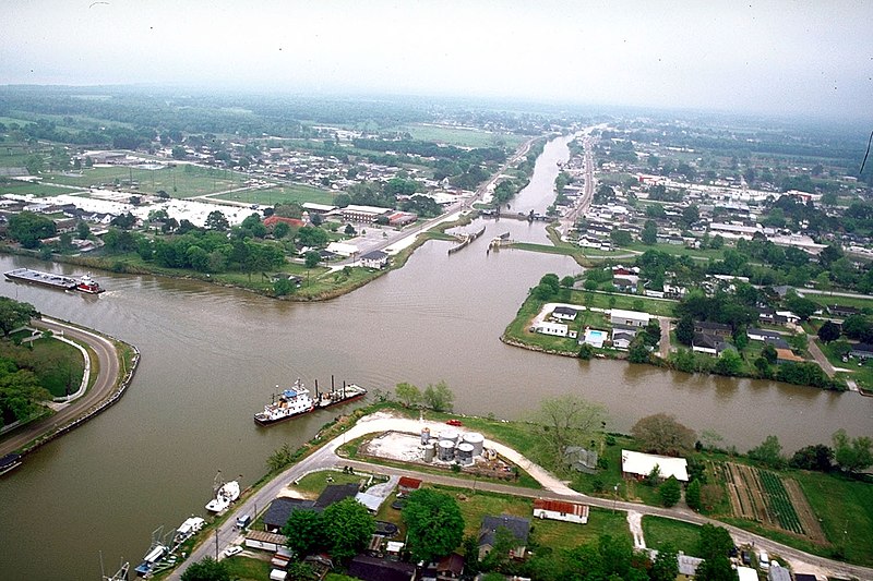
English: Aerial view of the intersection of Bayou Lafourche and the Gulf Intracoastal Waterway at Larose, Louisiana, USA. The waterway runs left–right across the photograph and the bayou runs off into the distance at the top. The U.S. Army Corps of Engineers has installed a floodgate on the bayou, visible at center. |
|||
| Ji̍t-kî | ||||
| Chhut-chhù |
U.S. Army Corps of Engineers Digital Visual Library Image page Image description page Digital Visual Library home page |
|||
| Chok-chiá | Arthur Belala, U.S. Army Corps of Engineers | |||
| 授權允准 (Bô siŏh-huòi sāi ciā ùng-giông) |
|
|||
| 圖中地點 | Larose, Louisiana, USA |
| 拍攝地點 | | 位於此地的本圖片與其他圖片: OpenStreetMap |
|---|
Tóng-àn le̍k-sú
Chhi̍h ji̍t-kî/sî-kan, khoàⁿ hit sî-chūn--ê tóng-àn.
| Ji̍t-kî/Sî-kan | 細張圖 | 寸尺 | Iōng-chiá | Chù-kái | |
|---|---|---|---|---|---|
| hiān-chāi | 2007-nî 4-goe̍h 1-ji̍t (lé-pài) 16:28 | | 1,500 × 1,000(278 KB) | DanMS | {{Information | Description = {{en|Aerial view of the intersection of Bayou Lafourche and the Gulf Intracoastal Waterway at Larose, Louisiana, USA. The bayou runs left–right across the photograph and the waterway runs off into the distance at the top |
Iáⁿ-siōng liân-kiat
Í-hā ê ia̍h liân kàu chit ê iáⁿ-siōng:
tóng-àn hō͘ lâng sái--ê chōng-hóng
Ē-kha--ê kî-thaⁿ wiki ēng tio̍h chit--ê tóng-àn:
- ar.wikipedia.org hō͘ lâng ēng--ê chêng-hêng
- azb.wikipedia.org hō͘ lâng ēng--ê chêng-hêng
- ca.wikipedia.org hō͘ lâng ēng--ê chêng-hêng
- ceb.wikipedia.org hō͘ lâng ēng--ê chêng-hêng
- ce.wikipedia.org hō͘ lâng ēng--ê chêng-hêng
- de.wikipedia.org hō͘ lâng ēng--ê chêng-hêng
- en.wikipedia.org hō͘ lâng ēng--ê chêng-hêng
- es.wikipedia.org hō͘ lâng ēng--ê chêng-hêng
- fa.wikipedia.org hō͘ lâng ēng--ê chêng-hêng
- fr.wikipedia.org hō͘ lâng ēng--ê chêng-hêng
- it.wikipedia.org hō͘ lâng ēng--ê chêng-hêng
- ja.wikipedia.org hō͘ lâng ēng--ê chêng-hêng
- lld.wikipedia.org hō͘ lâng ēng--ê chêng-hêng
- pl.wikipedia.org hō͘ lâng ēng--ê chêng-hêng
- pt.wikipedia.org hō͘ lâng ēng--ê chêng-hêng
- sh.wikipedia.org hō͘ lâng ēng--ê chêng-hêng
- sr.wikipedia.org hō͘ lâng ēng--ê chêng-hêng
- tt.wikipedia.org hō͘ lâng ēng--ê chêng-hêng
- uk.wikipedia.org hō͘ lâng ēng--ê chêng-hêng
- www.wikidata.org hō͘ lâng ēng--ê chêng-hêng
- zh.wikipedia.org hō͘ lâng ēng--ê chêng-hêng