
tóng-àn:Mole Valley UK locator map.svg

此 SVG 檔案的 PNG 預覽的大小:790 × 599 siōng-sò͘。 Kî-thaⁿ--ê kái-sek-tō͘: 317 × 240 siōng-sò͘ | 633 × 480 siōng-sò͘ | 1,013 × 768 siōng-sò͘ | 1,280 × 971 siōng-sò͘ | 2,560 × 1,942 siōng-sò͘ | 1,425 × 1,081 siōng-sò͘.
Choân kái-sek-tō͘ (SVG ùng-giông, chék-cháung: 1,425 × 1,081 chuông-só, ùng-giông duâi-nâung:948 KB)
|
|
Che sī tùi Wikimedia Commons ín--lâi ê chi̍t hūn tóng-àn. I tī hia ê kì-su̍t-ia̍h téng-bīn ê chu-sìn hián-sī ùi ē-té. |
| Soat-bêng |
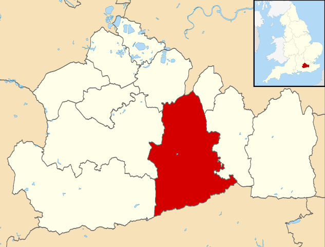
Map of Surrey, UK with Mole Valley highlighted. Equirectangular map projection on WGS 84 datum, with N/S stretched 160% |
| Ji̍t-kî | |
| Chhut-chhù |
|
| Chok-chiá | Nilfanion, created using Ordnance Survey data |
| 授權允准 (Bô siŏh-huòi sāi ciā ùng-giông) |
此檔案採用創用CC 姓名標示-相同方式分享 3.0 未在地化版本授權條款。 Biĕu-sê miàng-sáng: Contains Ordnance Survey data © Crown copyright and database right
|
Tóng-àn le̍k-sú
Chhi̍h ji̍t-kî/sî-kan, khoàⁿ hit sî-chūn--ê tóng-àn.
| Ji̍t-kî/Sî-kan | 細張圖 | 寸尺 | Iōng-chiá | Chù-kái | |
|---|---|---|---|---|---|
| hiān-chāi | 2011-nî 8-goe̍h 2-ji̍t (pài-jī) 09:26 | | 1,425 × 1,081(948 KB) | Nilfanion | {{Information |Description=Map of Surrey, UK with Mole Valley highlighted. Equirectangular map projection on WGS 84 datum, with N/S stretched 160% |Source=Ordnance Survey [https://www.ordnancesurvey.co |
Iáⁿ-siōng liân-kiat
Í-hā ê ia̍h liân kàu chit ê iáⁿ-siōng:
tóng-àn hō͘ lâng sái--ê chōng-hóng
Ē-kha--ê kî-thaⁿ wiki ēng tio̍h chit--ê tóng-àn:
- cy.wikipedia.org hō͘ lâng ēng--ê chêng-hêng
- en.wikipedia.org hō͘ lâng ēng--ê chêng-hêng
- Dorking
- Ashtead
- Leatherhead
- Fetcham
- Great Bookham
- Little Bookham
- Mole Valley
- Box Hill, Surrey
- City of London Freemen's School
- Abinger Hammer
- Leith Hill
- Headley Court
- Denbies Wine Estate
- Brockham
- Mickleham, Surrey
- Charlwood
- Westcott, Surrey
- St John's School, Leatherhead
- Polesden Lacey
- Bookham Commons
- Newdigate
- Abinger
- Betchworth
- Buckland, Surrey
- Westhumble
- Leatherhead F.C.
- Dorking F.C.
- The Ashcombe School
- Bookham F.C.
- Ashtead Common
- Bocketts Farm
- Headley, Surrey
- Ashtead railway station
- Mullard Space Science Laboratory
- Box Hill & Westhumble railway station
- Cherkley Court
- Leatherhead railway station
- Dorking railway station
- Holmwood railway station
- Ockley railway station
- Downsend School
- Box Hill School
- Bookham railway station
- Betchworth railway station
- Dorking West railway station
- Church of St Mary, Fetcham
- Dorking Deepdene railway station
- Leigh, Surrey
- St Andrew's Catholic School
檢視此檔案的更多全域使用狀況。