
tóng-àn:North West Leicestershire UK locator map.svg

此 SVG 檔案的 PNG 預覽的大小:761 × 600 siōng-sò͘。 Kî-thaⁿ--ê kái-sek-tō͘: 305 × 240 siōng-sò͘ | 609 × 480 siōng-sò͘ | 975 × 768 siōng-sò͘ | 1,280 × 1,009 siōng-sò͘ | 2,560 × 2,017 siōng-sò͘ | 1,425 × 1,123 siōng-sò͘.
Choân kái-sek-tō͘ (SVG ùng-giông, chék-cháung: 1,425 × 1,123 chuông-só, ùng-giông duâi-nâung:1,021 KB)
|
|
Che sī tùi Wikimedia Commons ín--lâi ê chi̍t hūn tóng-àn. I tī hia ê kì-su̍t-ia̍h téng-bīn ê chu-sìn hián-sī ùi ē-té. |
| Soat-bêng |
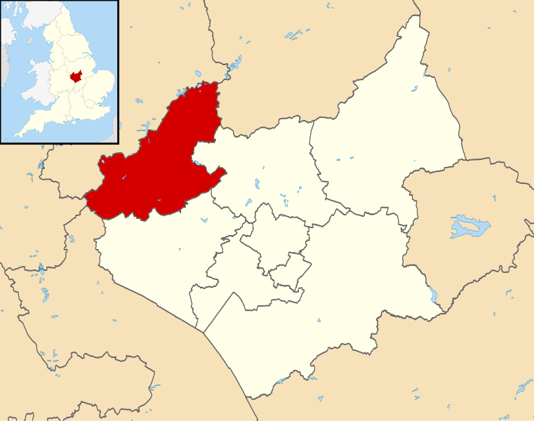
Map of Leicestershire, UK with North West Leicestershire highlighted. Equirectangular map projection on WGS 84 datum, with N/S stretched 160% |
| Ji̍t-kî | |
| Chhut-chhù |
|
| Chok-chiá | Nilfanion, created using Ordnance Survey data |
| 授權允准 (Bô siŏh-huòi sāi ciā ùng-giông) |
此檔案採用創用CC 姓名標示-相同方式分享 3.0 未在地化版本授權條款。 Biĕu-sê miàng-sáng: Contains Ordnance Survey data © Crown copyright and database right
|
Tóng-àn le̍k-sú
Chhi̍h ji̍t-kî/sî-kan, khoàⁿ hit sî-chūn--ê tóng-àn.
| Ji̍t-kî/Sî-kan | 細張圖 | 寸尺 | Iōng-chiá | Chù-kái | |
|---|---|---|---|---|---|
| hiān-chāi | 2011-nî 8-goe̍h 13-ji̍t (pài-la̍k) 21:53 | | 1,425 × 1,123(1,021 KB) | Nilfanion | {{Information |Description=Map of Leicestershire, UK with North West Leicestershire highlighted. Equirectangular map projection on WGS 84 datum, with N/S stretched 160% |Source=[[w:Ordnance Survey|Ordn |
Iáⁿ-siōng liân-kiat
Í-hā ê ia̍h liân kàu chit ê iáⁿ-siōng:
tóng-àn hō͘ lâng sái--ê chōng-hóng
Ē-kha--ê kî-thaⁿ wiki ēng tio̍h chit--ê tóng-àn:
- bg.wikipedia.org hō͘ lâng ēng--ê chêng-hêng
- cy.wikipedia.org hō͘ lâng ēng--ê chêng-hêng
- en.wikipedia.org hō͘ lâng ēng--ê chêng-hêng
- Ashby-de-la-Zouch
- Breedon on the Hill
- Moira, Leicestershire
- Donisthorpe
- North West Leicestershire
- Coalville
- Kegworth
- Measham
- Willesley
- Whitwick
- Castle Donington
- Copt Oak
- Acresford
- Ibstock
- Heather, Leicestershire
- Belton, Leicestershire
- Ravenstone, Leicestershire
- Charley, Leicestershire
- Appleby Magna
- Snarestone
- Swepstone
- Stretton en le Field
- Bardon, Leicestershire
- Worthington, Leicestershire
- Packington
- Diseworth
- Appleby Parva
- Ellistown
- Osgathorpe
- Snibston
- Oakthorpe
- Thringstone
- Long Whatton
- Oaks in Charnwood
- Swannington, Leicestershire
- Albert Village
- Battram
- Wilson, Leicestershire
- Hemington, Leicestershire
- Blackfordby
- Coleorton
- Staunton Harold
- Normanton le Heath
- Chilcote
- Isley cum Langley
- Hugglescote
- Donington le Heath
- Griffydam
檢視此檔案的更多全域使用狀況。