
tóng-àn:Northridge near Dayton aerial.jpg

Seng khoàⁿ chiàm-liōng: 800 × 600 siōng-sò͘. Kî-thaⁿ--ê kái-sek-tō͘: 320 × 240 siōng-sò͘ | 640 × 480 siōng-sò͘ | 1,024 × 768 siōng-sò͘ | 1,280 × 960 siōng-sò͘ | 2,272 × 1,704 siōng-sò͘.
Choân kái-sek-tō͘ (2,272 × 1,704 siōng-sò͘ , tóng-àn chiàm-liōng: 2.08 MB, MIME luī-hêng: image/jpeg)
|
|
Che sī tùi Wikimedia Commons ín--lâi ê chi̍t hūn tóng-àn. I tī hia ê kì-su̍t-ia̍h téng-bīn ê chu-sìn hián-sī ùi ē-té. |
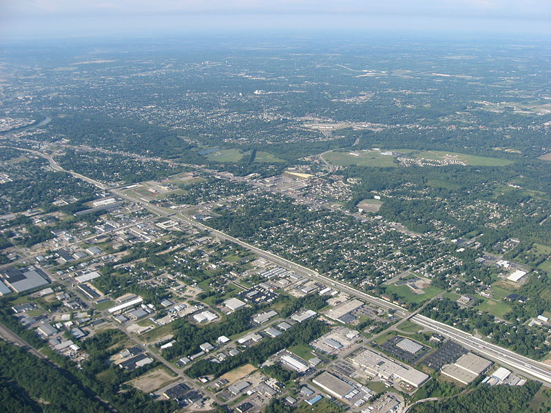
| Soat-bêng | Aerial view of Northridge, a community on the northeast side of the city of Dayton in Montgomery County, Ohio, United States. Interstate 75 is clearly visible in the middle of the picture, with the major intersection toward the left side of the picture being the highway's interchange with Needmore Road. The Great Miami River is visible on the far left edge of the picture. Picture taken from a Diamond Eclipse light airplane at an altitude of 4,480 feet MSL and a bearing of approximately 220º. | ||
| Ji̍t-kî | 攝於2008年8-goe̍h12日 | ||
| Chhut-chhù | Ka-tī chò--ê | ||
| Chok-chiá | Nyttend | ||
| 授權允准 (Bô siŏh-huòi sāi ciā ùng-giông) |
|
Tóng-àn le̍k-sú
Chhi̍h ji̍t-kî/sî-kan, khoàⁿ hit sî-chūn--ê tóng-àn.
| Ji̍t-kî/Sî-kan | 細張圖 | 寸尺 | Iōng-chiá | Chù-kái | |
|---|---|---|---|---|---|
| hiān-chāi | 2008-nî 9-goe̍h 19-ji̍t (pài-gō·) 00:58 | | 2,272 × 1,704(2.08 MB) | Nyttend | {{Information |Description=Aerial view of {{w|Northridge, Montgomery County, Ohio|Northridge}}, a community on the northeast side of the city of {{w|Dayton, Ohio|Dayton}} in {{w|Montgomery County, Ohio|Montgomery County}}, {{w|Ohio}}, {{w|United States}}. |
Iáⁿ-siōng liân-kiat
Í-hā ê ia̍h liân kàu chit ê iáⁿ-siōng:
tóng-àn hō͘ lâng sái--ê chōng-hóng
Ē-kha--ê kî-thaⁿ wiki ēng tio̍h chit--ê tóng-àn:
- azb.wikipedia.org hō͘ lâng ēng--ê chêng-hêng
- ca.wikipedia.org hō͘ lâng ēng--ê chêng-hêng
- ceb.wikipedia.org hō͘ lâng ēng--ê chêng-hêng
- en.wikipedia.org hō͘ lâng ēng--ê chêng-hêng
- es.wikipedia.org hō͘ lâng ēng--ê chêng-hêng
- eu.wikipedia.org hō͘ lâng ēng--ê chêng-hêng
- fa.wikipedia.org hō͘ lâng ēng--ê chêng-hêng
- it.wikipedia.org hō͘ lâng ēng--ê chêng-hêng
- pt.wikipedia.org hō͘ lâng ēng--ê chêng-hêng
- sr.wikipedia.org hō͘ lâng ēng--ê chêng-hêng
- ur.wikipedia.org hō͘ lâng ēng--ê chêng-hêng
- vi.wikipedia.org hō͘ lâng ēng--ê chêng-hêng
- www.wikidata.org hō͘ lâng ēng--ê chêng-hêng
- zh.wikipedia.org hō͘ lâng ēng--ê chêng-hêng