
tóng-àn:PIA24494-Mars-IngenuityHelicopter-FlightZoneMap-20210323.jpg

Choân kái-sek-tō͘ (3,388 × 2,144 siōng-sò͘ , tóng-àn chiàm-liōng: 957 KB, MIME luī-hêng: image/jpeg)
|
|
Che sī tùi Wikimedia Commons ín--lâi ê chi̍t hūn tóng-àn. I tī hia ê kì-su̍t-ia̍h téng-bīn ê chu-sìn hián-sī ùi ē-té. |
Khài-iàu
| Soat-bêng |
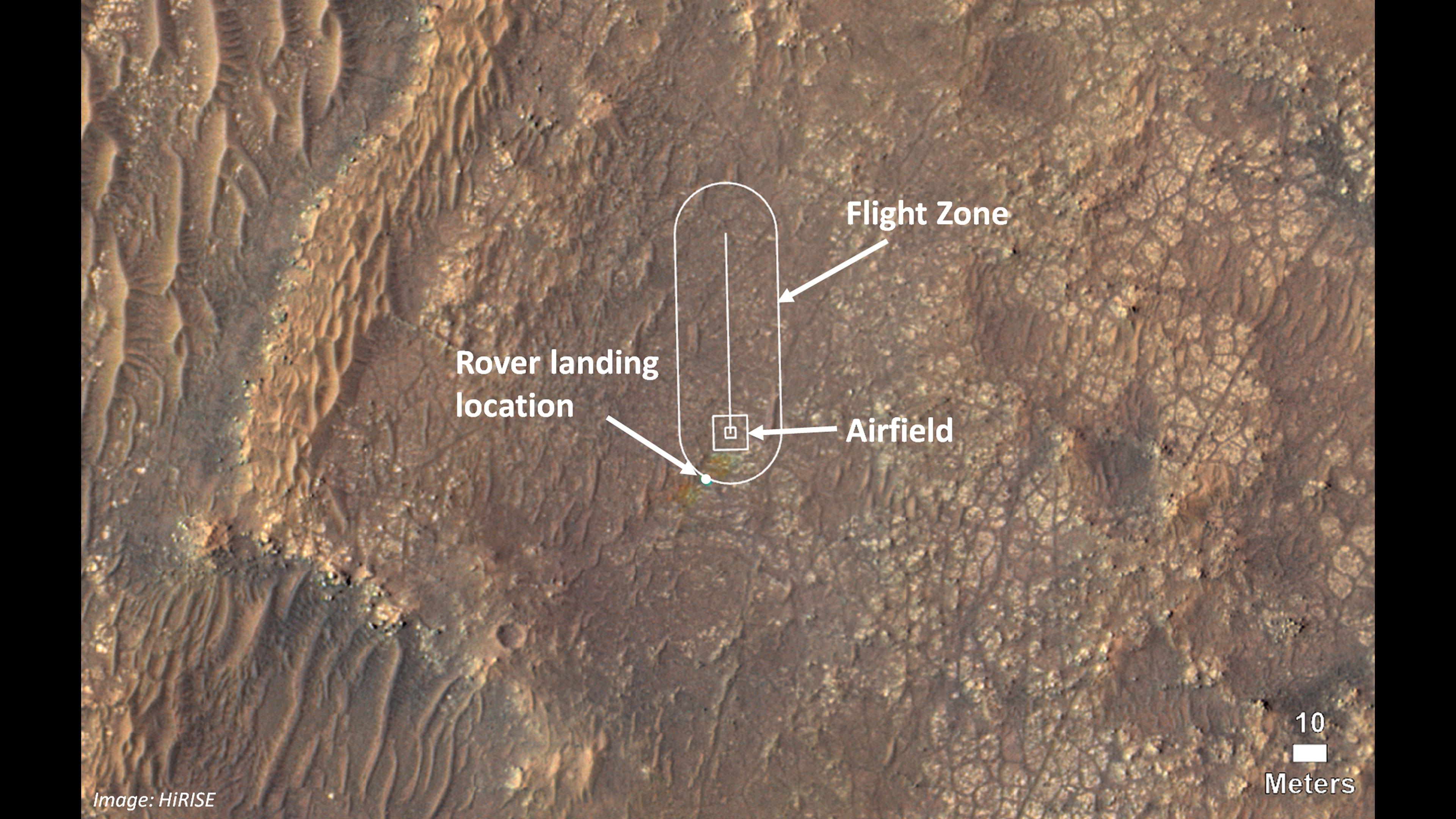
English: Mars - Ingenuity Helicopter - Flight Zone Map - March 23, 2021
PIA24494: Map of Ingenuity Helicopter Flight Zone https://photojournal.jpl.nasa.gov/catalog/PIA24494 This image shows where NASA's Ingenuity Mars Helicopter team will attempt its test flights. Helicopter engineers added the locations for the rover landing site (also known as "Octavia E. Butler Landing"), the airfield (the area where the helicopter will take off and return), and the flight zone (the area within which it will fly) on an image taken by the High Resolution Imaging Experiment (HiRISE) camera aboard NASA's Mars Reconnaissance Orbiter. Some small rainbow-like color distortions (which do not actually appear on the terrain of Mars) are seen in this image near the landing location because of the way pre- and post-landing color images were merged. The Ingenuity Mars Helicopter technology demonstration activity is supported by NASA's Science Mission Directorate, the NASA Aeronautics Research Mission Directorate, and the NASA Space Technology Mission Directorate. NASA's Jet Propulsion Laboratory built and manages operations of Perseverance and Ingenuity for the agency. Caltech in Pasadena, California, manages JPL for NASA. |
| Ji̍t-kî | |
| Chhut-chhù | https://photojournal.jpl.nasa.gov/jpeg/PIA24494.jpg |
| Chok-chiá | NASA/JPL-Caltech/University of Arizona |
Siū-khoân
| 本作品由NASA創作,屬於公有領域。根據NASA的版權政策:“NASA的創作除非另有聲明否則不受版權保護。”(參見:Template:PD-USGov/zh,NASA版權政策或JPL圖像使用政策) | ||
 |
警告:
|
| 此標籤不表示文件的著作權狀態。任何文件在附有此標籤的同時還需要一個有效的著作權標籤。請參閱許可協議說明頁面以了解更多資訊。 其他語言:
|
Tóng-àn le̍k-sú
Chhi̍h ji̍t-kî/sî-kan, khoàⁿ hit sî-chūn--ê tóng-àn.
| Ji̍t-kî/Sî-kan | 細張圖 | 寸尺 | Iōng-chiá | Chù-kái | |
|---|---|---|---|---|---|
| hiān-chāi | 2021-nî 3-goe̍h 25-ji̍t (pài-sì) 16:28 | | 3,388 × 2,144(957 KB) | Drbogdan | cropped - seems better |
| 2021-nî 3-goe̍h 25-ji̍t (pài-sì) 15:17 |  | 3,840 × 2,160(783 KB) | Drbogdan | Uploaded a work by NASA/JPL-Caltech/University of Arizona from https://photojournal.jpl.nasa.gov/jpeg/PIA24494.jpg with UploadWizard |
Iáⁿ-siōng liân-kiat
Bô poàⁿ ia̍h liân kàu chit tiuⁿ iáⁿ-siōng.
tóng-àn hō͘ lâng sái--ê chōng-hóng
Ē-kha--ê kî-thaⁿ wiki ēng tio̍h chit--ê tóng-àn:
- ar.wikipedia.org hō͘ lâng ēng--ê chêng-hêng
- ca.wikipedia.org hō͘ lâng ēng--ê chêng-hêng
- ckb.wikipedia.org hō͘ lâng ēng--ê chêng-hêng
- el.wikipedia.org hō͘ lâng ēng--ê chêng-hêng
- en.wikipedia.org hō͘ lâng ēng--ê chêng-hêng
- hr.wikipedia.org hō͘ lâng ēng--ê chêng-hêng
- id.wikipedia.org hō͘ lâng ēng--ê chêng-hêng
- ru.wikipedia.org hō͘ lâng ēng--ê chêng-hêng
- th.wikipedia.org hō͘ lâng ēng--ê chêng-hêng
- tl.wikipedia.org hō͘ lâng ēng--ê chêng-hêng
- vi.wikipedia.org hō͘ lâng ēng--ê chêng-hêng
- zh.wikipedia.org hō͘ lâng ēng--ê chêng-hêng