
tóng-àn:Population density of Ireland map2002.svg

此 SVG 檔案的 PNG 預覽的大小:480 × 600 siōng-sò͘。 Kî-thaⁿ--ê kái-sek-tō͘: 192 × 240 siōng-sò͘ | 384 × 480 siōng-sò͘ | 614 × 768 siōng-sò͘ | 819 × 1,024 siōng-sò͘ | 1,638 × 2,048 siōng-sò͘.
Choân kái-sek-tō͘ (SVG ùng-giông, chék-cháung: 800 × 1,000 chuông-só, ùng-giông duâi-nâung:621 KB)
|
|
Che sī tùi Wikimedia Commons ín--lâi ê chi̍t hūn tóng-àn. I tī hia ê kì-su̍t-ia̍h téng-bīn ê chu-sìn hián-sī ùi ē-té. |
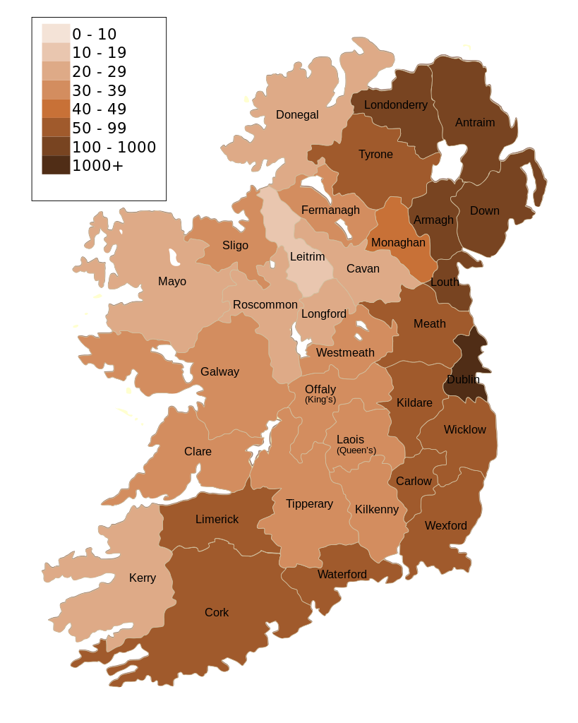
| Soat-bêng | Map of Ireland's population density (people per km2). Based upon Republic of Ireland - 2002 Census results. |
| Ji̍t-kî | (UTC) |
| Chhut-chhù | |
| Chok-chiá |
|
| 其他版本 | Derivative works of this file: Population density of Ireland map2002 RU.svg |
| 這是一張修飾過的圖片,即本圖片是用軟體修改過後的版本,修改的方式或內容有:Map of Ireland's population density (people per km2). Based upon Republic of Ireland - 2002 Census results.。原版圖片來源:Ireland complete.svg。修改者:The Illusional Ministry。
|
我,本作品的著作權持有者,決定用以下授權條款發佈本作品:
| 我,此作品的版權所有人,釋出此作品至公共領域。此授權條款在全世界均適用。 這可能在某些國家不合法,如果是的話: 我授予任何人有權利使用此作品於任何用途,除受法律約束外,不受任何限制。 |
原始上傳日誌
This image is a derivative work of the following images:
- File:Ireland_complete.svg licensed with PD-self
- 2007-06-23T17:06:44Z Future Perfect at Sunrise 800x1000 (594536 Bytes) {{Information |Description= |Source=self-made |Date= |Author= [[User:Future Perfect at Sunrise|Future Perfect at Sunrise]] }}
- 2007-06-23T16:45:52Z Future Perfect at Sunrise 800x1000 (590003 Bytes) {{Information |Description= |Source=self-made |Date= |Author= [[User:Future Perfect at Sunrise|Future Perfect at Sunrise]] }}
- 2007-06-23T16:35:48Z Future Perfect at Sunrise 2000x2500 (606764 Bytes) {{Information |Description=SVG map of Ireland. |Source=self-made |Date=23 June 2007 |Author= [[User:Future Perfect at Sunrise|Future Perfect at Sunrise]] }} Note: the SVG code contains separate levels showing boundaries and
Uploaded with derivativeFX
Tóng-àn le̍k-sú
Chhi̍h ji̍t-kî/sî-kan, khoàⁿ hit sî-chūn--ê tóng-àn.
| Ji̍t-kî/Sî-kan | 細張圖 | 寸尺 | Iōng-chiá | Chù-kái | |
|---|---|---|---|---|---|
| hiān-chāi | 2009-nî 10-goe̍h 17-ji̍t (pài-la̍k) 14:30 | | 800 × 1,000(621 KB) | The Illusional Ministry | Dublin now in black text |
| 2009-nî 10-goe̍h 17-ji̍t (pài-la̍k) 14:27 |  | 800 × 1,000(621 KB) | The Illusional Ministry | {{Information |Description=Map of Ireland's population density (people per km2). Based upon Republic of Ireland - 2002 Census results. |Source=*File:Ireland_complete.svg |Date=2009-10-17 14:25 (UTC) |Author=*File:Ireland_complete.svg: '''Futur |
Iáⁿ-siōng liân-kiat
Bô poàⁿ ia̍h liân kàu chit tiuⁿ iáⁿ-siōng.
tóng-àn hō͘ lâng sái--ê chōng-hóng
Ē-kha--ê kî-thaⁿ wiki ēng tio̍h chit--ê tóng-àn:
- de.wikipedia.org hō͘ lâng ēng--ê chêng-hêng
- gv.wikipedia.org hō͘ lâng ēng--ê chêng-hêng
- he.wikipedia.org hō͘ lâng ēng--ê chêng-hêng
- hu.wikipedia.org hō͘ lâng ēng--ê chêng-hêng
- kn.wikipedia.org hō͘ lâng ēng--ê chêng-hêng
- sd.wikipedia.org hō͘ lâng ēng--ê chêng-hêng
- te.wikipedia.org hō͘ lâng ēng--ê chêng-hêng