
tóng-àn:Stratford-on-Avon UK locator map.svg

此 SVG 檔案的 PNG 預覽的大小:493 × 599 siōng-sò͘。 Kî-thaⁿ--ê kái-sek-tō͘: 197 × 240 siōng-sò͘ | 395 × 480 siōng-sò͘ | 632 × 768 siōng-sò͘ | 843 × 1,024 siōng-sò͘ | 1,686 × 2,048 siōng-sò͘ | 1,042 × 1,266 siōng-sò͘.
Choân kái-sek-tō͘ (SVG ùng-giông, chék-cháung: 1,042 × 1,266 chuông-só, ùng-giông duâi-nâung:911 KB)
|
|
Che sī tùi Wikimedia Commons ín--lâi ê chi̍t hūn tóng-àn. I tī hia ê kì-su̍t-ia̍h téng-bīn ê chu-sìn hián-sī ùi ē-té. |
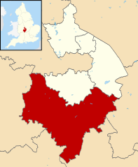
| Soat-bêng | Map of Warwickshire, with Stratford-on-Avon highlighted. |
| Ji̍t-kî | (UTC) |
| Chhut-chhù | |
| Chok-chiá |
|
.svg)
我,本作品的著作權持有者,決定用以下授權條款發佈本作品:
此檔案採用創用CC 姓名標示-相同方式分享 3.0 未在地化版本授權條款。
- 你會使自由:
- 分享 – kho͘-pih, hoat-pò͘ kap thoân-pò͘ pún chok
- 重新修改 – kái-pian pún chok-phín
- Àn i-hā ê tiâu-kiāⁿ
- 標示名姓 – 您必須指名出正確的製作者,和提供授權條款的連結,以及表示是否有對內容上做出變更。您可以用任何合理的方式來行動,但不得以任何方式表明授權條款是對您許可或是由您所使用。
- 仝款方式方享 – Lí nā kái-tōng, piàn-khoán, he̍k-chiá kun-kù pún chok chhòng-chō, lí kaⁿ-taⁿ ē-tàng ēng kap pún chok kâng-khoán he̍k-chiá saⁿ-chhiūⁿ ê hí-khó lâi hoat-pò͘ chò--chhut-lâi ê chok-phín.
原始上傳日誌
This image is a derivative work of the following images:
- File:Warwickshire UK district map (blank).svg licensed with Cc-by-sa-3.0
- 2010-08-22T08:21:14Z Nilfanion 1042x1266 (931105 Bytes) +inset, water colour tweak
- 2010-07-16T23:57:57Z Nilfanion 1042x1266 (557360 Bytes) {{Information |Description=Map of [[w:Warwickshire|Warwickshire]], UK with districts shown. Equirectangular map projection on WGS 84 datum, with N/S stretched 160% Geographic limits: *West: 2.10W *East: 1.10W *North: 52.70N
Tóng-àn le̍k-sú
Chhi̍h ji̍t-kî/sî-kan, khoàⁿ hit sî-chūn--ê tóng-àn.
| Ji̍t-kî/Sî-kan | 細張圖 | 寸尺 | Iōng-chiá | Chù-kái | |
|---|---|---|---|---|---|
| hiān-chāi | 2011-nî 8-goe̍h 13-ji̍t (pài-la̍k) 09:14 | | 1,042 × 1,266(911 KB) | Renly~commonswiki | {{Information |Description=Map of Warwickshire, with Stratford-on-Avon highlighted. |Source=*File:Warwickshire UK district map (blank).svg |Date=2011-08-13 09:14 (UTC) |Author=*File:Warwickshire UK district map (blank).svg: [[User:Nilfanion|Ni |
.svg)
Iáⁿ-siōng liân-kiat
Í-hā ê ia̍h liân kàu chit ê iáⁿ-siōng:
tóng-àn hō͘ lâng sái--ê chōng-hóng
Ē-kha--ê kî-thaⁿ wiki ēng tio̍h chit--ê tóng-àn:
- cy.wikipedia.org hō͘ lâng ēng--ê chêng-hêng
- en.wikipedia.org hō͘ lâng ēng--ê chêng-hêng
- es.wikipedia.org hō͘ lâng ēng--ê chêng-hêng
- fr.wikipedia.org hō͘ lâng ēng--ê chêng-hêng
- Stratford-upon-Avon
- Admington
- Loxley (Warwickshire)
- Kineton
- Gaydon
- Alcester
- Little Compton (Warwickshire)
- Tanworth-in-Arden
- Snitterfield
- Stratford-on-Avon (district)
- Henley-in-Arden
- Studley
- Binton
- Salford Priors
- Southam
- Liste des paroisses civiles du Warwickshire
- Wormleighton
- Wixford
- Wilmcote
- Whichford
- Whatcote
- Tysoe
- Ufton
- Ullenhall
- Watergall
- Welford-on-Avon
- Wellesbourne
- Weston-on-Avon
- Tidmington
- Temple Grafton
- Sutton-under-Brailes
- Stretton-on-Fosse
- Sambourne (Royaume-Uni)
- Shotteswell
- Shipston-on-Stour
- Long Itchington
- Bishop's Itchington
- Harbury
- Farnborough (Warwickshire)
- Great Alne
- Modèle:Palette Stratford-on-Avon
- Alderminster
- Aston Cantlow
- Avon Dassett
- Burton Dassett
- Bearley
- Bidford-on-Avon
檢視此檔案的更多全域使用狀況。