
tóng-àn:ScotlandSouthAyrshire.png
Bô khah koân ê kái-sek-tō͘.
ScotlandSouthAyrshire.png (200 × 230 siōng-sò͘ , tóng-àn chiàm-liōng: 4 KB, MIME luī-hêng: image/png)
|
|
Che sī tùi Wikimedia Commons ín--lâi ê chi̍t hūn tóng-àn. I tī hia ê kì-su̍t-ia̍h téng-bīn ê chu-sìn hián-sī ùi ē-té. |
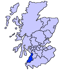
South Ayrshire unitary council
Slightly edited version of a map drawn by Morwen

|
已授權您依據自由軟體基金會發行的無固定段落、封面文字和封底文字GNU自由文件授權條款1.2版或任意後續版本,對本檔進行複製、傳播和/或修改。該協議的副本列在GNU自由文件授權條款中。 |
| 此檔案採用創用CC 姓名標示-相同方式分享 3.0 未在地化版本授權條款。 | ||
| ||
| 已新增授權條款標題至此檔案,作為GFDL授權更新的一部份。 |
Tóng-àn le̍k-sú
Chhi̍h ji̍t-kî/sî-kan, khoàⁿ hit sî-chūn--ê tóng-àn.
| Ji̍t-kî/Sî-kan | 細張圖 | 寸尺 | Iōng-chiá | Chù-kái | |
|---|---|---|---|---|---|
| hiān-chāi | 2005-nî 5-goe̍h 17-ji̍t (pài-jī) 21:41 | | 200 × 230(4 KB) | Voyager | |
| 2005-nî 5-goe̍h 17-ji̍t (pài-jī) 21:40 |  | 200 × 230(4 KB) | Voyager | South Ayrshire unitary council Slightly edited version of a map drawn by Morwen {{GFDL}} Category:Maps of Scottish unitary councils |
Iáⁿ-siōng liân-kiat
Í-hā ê ia̍h liân kàu chit ê iáⁿ-siōng:
tóng-àn hō͘ lâng sái--ê chōng-hóng
Ē-kha--ê kî-thaⁿ wiki ēng tio̍h chit--ê tóng-àn:
- be.wikipedia.org hō͘ lâng ēng--ê chêng-hêng
- bg.wikipedia.org hō͘ lâng ēng--ê chêng-hêng
- cy.wikipedia.org hō͘ lâng ēng--ê chêng-hêng
- de.wikipedia.org hō͘ lâng ēng--ê chêng-hêng
- en.wikipedia.org hō͘ lâng ēng--ê chêng-hêng
- eu.wikipedia.org hō͘ lâng ēng--ê chêng-hêng
- Hegoaldeko Ayrshire
- Ayr
- Lankide:Euskaldunaa
- Maybole
- Prestwick
- Txantiloi:Hegoaldeko Ayrshire
- Wikiproiektu:Irlanda, Gales eta Eskoziako udalerriak
- Alloway
- Girvan
- Troon
- Annbank
- Ballantrae
- Barassie (Hegoaldeko Ayrshire)
- Coylton
- Craigie Udalerria eta Parrokia
- Dundonald (South Ayrshire)
- Failford
- Heronsford
- Joppa (Hegoaldeko Ayrshire)
- Loans (Hegoaldeko Ayrshire)
- Millmannoch
- Monkton (Ayrshire)
- Mossblown
- Old Rome (Hegoaldeko Ayrshire)
- Symington (Hegoaldeko Ayrshire)
- Tarbolton
- Barr (Ayrshire)
- Barrhill (Hegoaldeko Ayrshire)
- Colmonell
- Crosshill (Hegoaldeko Ayrshire)
- Dailly
- Dunure
- Kirkmichael
- Kirkoswald (Hegoaldeko Ayrshire)
- Maidens
- Minishant
- Old Dailly
- Straiton
- Belmont (Ayr)
- Doonfoot
- Montgomerieston
- Heathfield (Hegoaldeko Ayrshire)
- Kincaidston
檢視此檔案的更多全域使用狀況。