
tóng-àn:Srivijaya Empire.svg

此 SVG 檔案的 PNG 預覽的大小:468 × 476 siōng-sò͘。 Kî-thaⁿ--ê kái-sek-tō͘: 236 × 240 siōng-sò͘ | 472 × 480 siōng-sò͘ | 755 × 768 siōng-sò͘ | 1,007 × 1,024 siōng-sò͘ | 2,014 × 2,048 siōng-sò͘.
Choân kái-sek-tō͘ (SVG ùng-giông, chék-cháung: 468 × 476 chuông-só, ùng-giông duâi-nâung:336 KB)
|
|
Che sī tùi Wikimedia Commons ín--lâi ê chi̍t hūn tóng-àn. I tī hia ê kì-su̍t-ia̍h téng-bīn ê chu-sìn hián-sī ùi ē-té. |
Khài-iàu
| Soat-bêng |
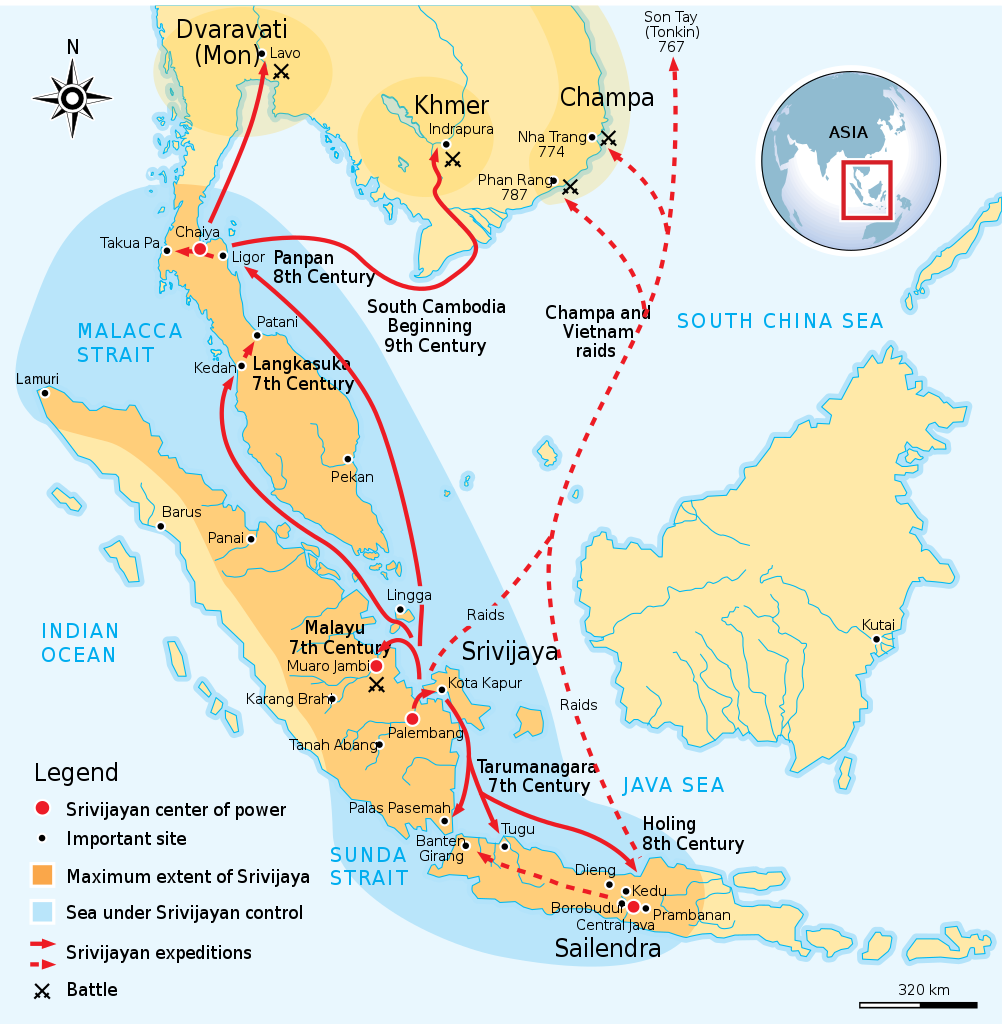
English: Maximum extent of Srivijaya Empire around 8th century. Expanding from Sumatra, Central Java, to Malay Peninsula. The red arrows show the series of Srivijayan expedition and conquest, in diplomatic alliances, military campaign, or naval raids. |
||
| Ji̍t-kî | |||
| Chhut-chhù | Own work by uploader,redrawed from Munoz "Early Kingdoms of the Indonesian Archipelago and the Malay Peninsula" page 128 | ||
| Chok-chiá | Gunawan Kartapranata | ||
| 授權允准 (Bô siŏh-huòi sāi ciā ùng-giông) |
我,本作品的著作權持有者,決定用以下授權條款發佈本作品: 此檔案採用創用CC 姓名標示-相同方式分享 3.0 未在地化版本授權條款。
Nṳ̄ buóh dĭk sié-nó̤h sêu-guòng dèu-kuāng dŭ kō̤-ī gēng. |
||
| 其他版本 |
[]
|


|
This SVG file contains embedded text that can be translated into your language, using any capable SVG editor, text editor or the SVG Translate tool. For more information see: About translating SVG files. |
References
Resources used to create the map:
- Munoz, Paul Michel (2006年) 《 Early Kingdoms of the Indonesian Archipelago and the Malay Peninsula》, Sin-ka-pho: Editions Didier Millet, pp. 128, 141 ISBN: 9814155675.
Tóng-àn le̍k-sú
Chhi̍h ji̍t-kî/sî-kan, khoàⁿ hit sî-chūn--ê tóng-àn.
| Ji̍t-kî/Sî-kan | 細張圖 | 寸尺 | Iōng-chiá | Chù-kái | |
|---|---|---|---|---|---|
| hiān-chāi | 2014-nî 12-goe̍h 3-ji̍t (pài-saⁿ) 22:41 | | 468 × 476(336 KB) | Pratyeka | Reposition 'Malacca Straight' label for improved clarity. |
| 2014-nî 12-goe̍h 3-ji̍t (pài-saⁿ) 22:33 |  | 468 × 476(336 KB) | Pratyeka | Addition of Lamuri, an important point in northwestern Sumatra identified as contemporary and whose location at Lhok Lambaro is reasoned by E. Edwards McKinnon in ''[http://www.scribd.com/doc/8410125/A-note-of-Lamuri-Lambri-Sumatra-Straits-of-Melaka-Ma... | |
| 2009-nî 8-goe̍h 26-ji̍t (pài-saⁿ) 19:15 |  | 468 × 476(288 KB) | Gunkarta | {{Information |Description={{en|1=Maximum extent of Srivijaya Empire around 8th century. Expanding from Sumatra, Central Java, to Malay Peninsula. The red arrows show the series of Srivijayan expedition and conquest, in diplomatic alliances, military camp |
Iáⁿ-siōng liân-kiat
Í-hā ê ia̍h liân kàu chit ê iáⁿ-siōng:
tóng-àn hō͘ lâng sái--ê chōng-hóng
Ē-kha--ê kî-thaⁿ wiki ēng tio̍h chit--ê tóng-àn:
- azb.wikipedia.org hō͘ lâng ēng--ê chêng-hêng
- ba.wikipedia.org hō͘ lâng ēng--ê chêng-hêng
- be.wikipedia.org hō͘ lâng ēng--ê chêng-hêng
- bg.wikipedia.org hō͘ lâng ēng--ê chêng-hêng
- bn.wikipedia.org hō͘ lâng ēng--ê chêng-hêng
- ca.wikipedia.org hō͘ lâng ēng--ê chêng-hêng
- cs.wikipedia.org hō͘ lâng ēng--ê chêng-hêng
- da.wikipedia.org hō͘ lâng ēng--ê chêng-hêng
- en.wikipedia.org hō͘ lâng ēng--ê chêng-hêng
- eo.wikipedia.org hō͘ lâng ēng--ê chêng-hêng
- fa.wikipedia.org hō͘ lâng ēng--ê chêng-hêng
- fi.wikibooks.org hō͘ lâng ēng--ê chêng-hêng
- ha.wikipedia.org hō͘ lâng ēng--ê chêng-hêng
- hi.wikipedia.org hō͘ lâng ēng--ê chêng-hêng
- hu.wikipedia.org hō͘ lâng ēng--ê chêng-hêng
- hy.wikipedia.org hō͘ lâng ēng--ê chêng-hêng
- id.wikipedia.org hō͘ lâng ēng--ê chêng-hêng
- io.wikipedia.org hō͘ lâng ēng--ê chêng-hêng
- it.wikipedia.org hō͘ lâng ēng--ê chêng-hêng
- ja.wikipedia.org hō͘ lâng ēng--ê chêng-hêng
- ja.wikibooks.org hō͘ lâng ēng--ê chêng-hêng
- ka.wikipedia.org hō͘ lâng ēng--ê chêng-hêng
- km.wikipedia.org hō͘ lâng ēng--ê chêng-hêng
- ko.wikipedia.org hō͘ lâng ēng--ê chêng-hêng
- lt.wikipedia.org hō͘ lâng ēng--ê chêng-hêng
- lv.wikipedia.org hō͘ lâng ēng--ê chêng-hêng
- min.wikipedia.org hō͘ lâng ēng--ê chêng-hêng
- ml.wikipedia.org hō͘ lâng ēng--ê chêng-hêng
- mr.wikipedia.org hō͘ lâng ēng--ê chêng-hêng
檢視此檔案的更多全域使用狀況。